Over 70,000 photos covering a variety of topics from Marriott Library Special Collections
TO
Filters: Collection Name: "Herbert E. Gregory" Date: "1914" Format: "image/jpeg" Collection: "uum_map" Type: "Image" Format: image Setname: !(ir* OR ehsl*)
| Title | Collection Number And Name | Photo Number | ||
|---|---|---|---|---|
| 26 |
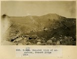 |
General view of erratics, Garnet Ridge, 1914 | P0013 Herbert E. Gregory Photograph Collection | P0013n07_073_1131 |
| 27 |
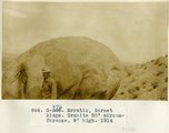 |
Erratic, Garnet Ridge. Granit 50' circumference, 9' high, 1914 | P0013 Herbert E. Gregory Photograph Collection | P0013n07_074_1132 |
| 28 |
 |
Edge of Comb looking SW 2± mi. NW of Garnet Ridge 1914 | P0013 Herbert E. Gregory Photograph Collection | P0013n07_074_1133 |
| 29 |
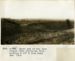 |
Upper end of San Juan Canyon thru Oilfields fold. Looking N 10° W from Mule Ear, 1914 | P0013 Herbert E. Gregory Photograph Collection | P0013n07_075_1134 |
| 30 |
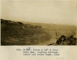 |
Views S 15° E from Mule Ear, looking between inner and outer Comb, 1914 | P0013 Herbert E. Gregory Photograph Collection | P0013n07_075_1135 |
| 31 |
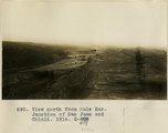 |
View north from Mule Ear. Junction of San Juan and Chinli, 1914 | P0013 Herbert E. Gregory Photograph Collection | P0013n07_076_1136 |
| 32 |
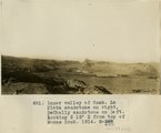 |
Inner valley of Comb, La Plata sandstone on right, DeChelly sandstone on left. Looking N 15° E from top of Moses Rock, 1914 | P0013 Herbert E. Gregory Photograph Collection | P0013n07_076_1137 |
| 33 |
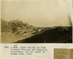 |
Inner valley of Comb between Wingate and DeChelly sandstone. 3/4 mi east of Moses Rock, 1914 | P0013 Herbert E. Gregory Photograph Collection | P0013n07_077_1138 |
| 34 |
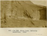 |
Moses Rock, DeChelly sandstone, 1914 | P0013 Herbert E. Gregory Photograph Collection | P0013n07_077_1139 |
| 35 |
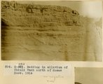 |
Bedding in alluvium of Chinli Wash north of Moses Rock, 1914 | P0013 Herbert E. Gregory Photograph Collection | P0013n07_078_1140 |
| 36 |
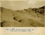 |
Tilted Chinli beds, 1 1/2 mile west of Tonygis, 1914 | P0013 Herbert E. Gregory Photograph Collection | P0013n07_078_1141 |
| 37 |
 |
Alcove in DeChelly sandstone near Mule Ear, 1914 | P0013 Herbert E. Gregory Photograph Collection | P0013n07_079_1142 |
| 38 |
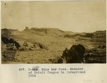 |
Mule Ear Pass. Meander of Chinli Canyon in foreground 1914 | P0013 Herbert E. Gregory Photograph Collection | P0013n07_079_1143 |
| 39 |
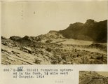 |
Chinli Formation upturned in the Comb, 1 1/2 mile west of Toaygis, 1914 | P0013 Herbert E. Gregory Photograph Collection | P0013n07_080_1144 |
| 40 |
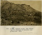 |
Garnet Ridge. Man standing at stratum of glacial conglomerate, 1914 | P0013 Herbert E. Gregory Photograph Collection | P0013n07_080_1145 |
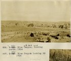
| 41 |
 |
Comb Monocline, 2 miles east of mouth of Sagy, at Marsh Pass, 1914 | P0013 Herbert E. Gregory Photograph Collection | P0013n07_081_1146 |
| 42 |
 |
Marsh Pass, looking east, 1914 | P0013 Herbert E. Gregory Photograph Collection | P0013n07_081_1147 |
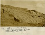
| 43 |
 |
McElmo-Dakota contact, Moenkopi valley, 6± NE of Blue Canyon store, 1914 | P0013 Herbert E. Gregory Photograph Collection | P0013n07_082_1148 |
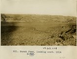
| 44 |
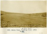 |
Marsh Pass, looking west, 1914 | P0013 Herbert E. Gregory Photograph Collection | P0013n07_082_1149 |
| 45 |
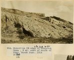 |
Monocline SE edge of Skeleton Mesa, 2 mi. east of mouth of Sagy, Marsh Pass, 1914 | P0013 Herbert E. Gregory Photograph Collection | P0013n07_083_1150 |
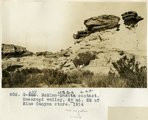
| 46 |
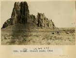 |
Church Rock, 1914 | P0013 Herbert E. Gregory Photograph Collection | P0013n07_083_1151 |
| 47 |
 |
Blue Canyon, looking north, 1914 | P0013 Herbert E. Gregory Photograph Collection | P0013n07_084_1152 |
| 48 |
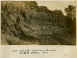 |
Trenched alluvium, Togusja Canyon, 1914 | P0013 Herbert E. Gregory Photograph Collection | P0013n07_084_1153 |
| 49 |
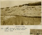 |
Contact, McElmo and Mancos, 3 mi. NE of Blue Canyon store, 1914 | P0013 Herbert E. Gregory Photograph Collection | P0013n07_085_1154 |
| 50 |
 |
Contact Navajo sandstone and McElmo, Blue Canyon, 1914 | P0013 Herbert E. Gregory Photograph Collection | P0013n07_085_1155 |