|
|
Title | Collection Number And Name | Photo Number |
| 101 |
 |
Cliff, LaPlata on Dolores at mouth of Sagy at Sosi canyon, Ariz., 1910 (Photo G166) | P0013 Herbert E. Gregory Photograph Collection | P0013n04_40_0577 |
| 102 |
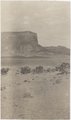 |
Cliff, LaPlata on Dolores at mouth of Sagy at Sosi canyon, AZ. 1910 (Photo G166) | P0013 Herbert E. Gregory Photograph Collection | P0013n04_40_0577 |
| 103 |
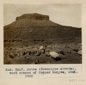 |
Butte (Moencopie strata), east branch of Copper Canyon, Utah, 1910 (Photo G167) | P0013 Herbert E. Gregory Photograph Collection | P0013n04_42_0579 |
| 104 |
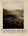 |
Noki Canyon, Utah, looking north down stream and across San Juan River, showing synclinal structure, 1910. | P0013 Herbert E. Gregory Photograph Collection | P0013n04_42_0580 |
| 105 |
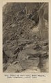 |
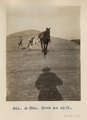
Trail up west wall, Noki Canyon, Utah (Townsend photo), 1910. | P0013 Herbert E. Gregory Photograph Collection | P0013n04_44_0582 |
| 106 |
 |
General view, Pahute [Noki] canyon, Utah, LaPlata on Dolores (Townsend photo), 1910. | P0013 Herbert E. Gregory Photograph Collection | P0013n04_45_0583 |
| 107 |
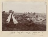 |
Camp, Pahute Mesa, Navajo Mtn in distance (Townsend photograph) | P0013 Herbert E. Gregory Photograph Collection | P0013n04_45verso_0584 |
| 108 |
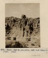 |
Earth Pillars. Pahute Canyon, Utah, 1910 (Photo G169) | P0013 Herbert E. Gregory Photograph Collection | P0013n04_47_0586 |
| 109 |
 |
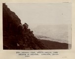
View, Navajo Mt., Utah, from west run of Pahute Canyon, 1910 (Photo G170A) | P0013 Herbert E. Gregory Photograph Collection | P0013n04_47_0587 |
| 110 |
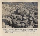 |
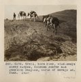
Talus or rock stream near spring, elevation 9000 ft., on Navajo Mt., 1910 (Photo N-M95) | P0013 Herbert E. Gregory Photograph Collection | P0013n04_50_0590 |
| 111 |
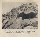 |
Top of Navajo Mt., Utah. Blocks of quartzite, 1910 (Photo G171) | P0013 Herbert E. Gregory Photograph Collection | P0013n04_50_0591 |
| 112 |
 |
Trail, bare rock, wind-swept steep slopes, between Beaver and Junction canyons, north of Navajo Mt., Utah, 1910 (Photo G172) | P0013 Herbert E. Gregory Photograph Collection | P0013n04_50_0592 |
| 113 |
 |
Same as G172 (Trail from Navajo Mountain to Rainbow Bridge, Utah, in 1910, photo N-M96) | P0013 Herbert E. Gregory Photograph Collection | P0013n04_51_0593 |
| 114 |
 |
Same as G172 (Trail from Navajo Mountain to Rainbow Bridge, Utah, in 1910; photo G193) | P0013 Herbert E. Gregory Photograph Collection | P0013n04_51_0594 |
| 115 |
 |
Owl Bridge, Nasja Canyon, Utah; north base of Navajo Mt., 1910 (Photo G174) | P0013 Herbert E. Gregory Photograph Collection | P0013n04_55_0597 |
| 116 |
 |
Same as G174 (Owl Bridge, Nasja Canyon, Utah, 1910, photo N-M97) | P0013 Herbert E. Gregory Photograph Collection | P0013n04_56_0599 |
| 117 |
 |
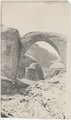
Barohoini Natural Bridge, 10+ mi. northwest of Navajo Mt., Utah in LaPlata strata, 1910. Looking down stream northwest from distance of 1+ mi. (Photo G176) | P0013 Herbert E. Gregory Photograph Collection | P0013n04_57_0604 |
| 118 |
 |
Same as G176 (Rainbow Bridge, distance 1/4+ mile from upstream, 1910 (Photo G177) | P0013 Herbert E. Gregory Photograph Collection | P0013n04_57_0605 |
| 119 |
 |
Same as G176 (Barohoini Bridge from upstream, nearer view, 1910, Photo G178) | P0013 Herbert E. Gregory Photograph Collection | P0013n04_58_0607 |
| 120 |
 |
Same as G176 (Barohoini Bridge from upstream, nearer view, 1910, Photo G178) | P0013 Herbert E. Gregory Photograph Collection | P0013n04_58_0607 |
| 121 |
 |
Same as G178 (Barohoini Bridge from upstream, 1910, Photo N-M99) | P0013 Herbert E. Gregory Photograph Collection | P0013n04_58_0608 |
| 122 |
 |
Barohoini Bridge, looking downstream, i.e. northwest, 1910 (Photo G178A) | P0013 Herbert E. Gregory Photograph Collection | P0013n04_58verso_0609 |
| 123 |
 |
Barohoini Bridge, looking downstream, i.e. northwest, 1910 (Photo G178A) | P0013 Herbert E. Gregory Photograph Collection | P0013n04_58verso_0609 |
| 124 |
 |
Barohoini Bridge, looking upstream, 1910 (Photo G179) | P0013 Herbert E. Gregory Photograph Collection | P0013n04_59_0610 |
| 125 |
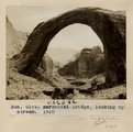 |
Barohoini Bridge, looking upstream, 1910 (Photo G179) | P0013 Herbert E. Gregory Photograph Collection | P0013n04_59_0610 |