Home
Browse
Ask Us
Chat
Harmful Language Statement
Log in
Photo Archives
Advanced Search
About
Over 90,000 photos covering a variety of topics from Marriott Library Special Collections.
Year
1908
1909
1910
1911
1912
1913
1914
TO
1908
1909
1910
1911
1912
1913
1914
Type
Image
12
Format
image/jpeg
12
Collection
Photo Archives
12
Filters:
Collection Name:
"H.W. Bailey"
Spatial Coverage:
"Nevada"
1
-
25
of
12
Gallery view
Number of results to display per page
10
25
50
100
200
Sort by Relevance
Sort by Title A-Z
Sort by Title Z-A
Sort by Date Ascending
Sort by Date Descending
Sort by Last Modified Ascending
Sort by Last Modified Descending
Title
Date
Type
1
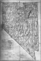
1908 U. S. Land Office Map of the State of Nevada; showing location of Fairview, Churchill County, Nevada
1908
Image
2
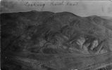
Looking Northeast -- Joe Dandy, Scotchman
1908; 1909; 1910; 1911; 1912
Image
3
Machinery
1908; 1909; 1910; 1911; 1912
Image
4
Machinery
1908; 1909; 1910; 1911; 1912
Image
5
Map of Nevada 1908; Photographic copy of General Land Office Mape of the State of Nevada, with location of Ophir Mines drawn in
1908; 1909; 1910; 1911; 1912
Image
6
Nevada - California Hawthorne Quadrangle; 1909
1909
Image
7
Nevada - Carson Sink Quadrangle; 1910
1910
Image
8
Nevada Mineral Districts 1912; Photographic copy of Map of Nevada showing location of Mining Districts and Ophir Mines
1908; 1909; 1910; 1911; 1912
Image
9
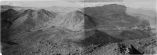
Ophir Camp, Birds eye. Neco mining district - Nevada
1908; 1909; 1910; 1911; 1912
Image
10
Photographic copy of List of Mining Districts; 1912-1914
1914
Image
11
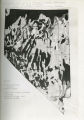
Photographic copy of U.S. Geologic Survey Publication Geological Chart of the State of Nevada, with location of Ophir Mines drawn in
1908; 1909; 1910; 1911; 1912
Image
12
Photographic copy of U.S. Geologic Survey Publication Geological Chart of the State of Nevada; Showing location of Fairview, Churchill County, Nevada
Image
1
-
25
of
12