Home
Browse
Ask Us
Chat
Harmful Language Statement
Log in
Photo Archives
Advanced Search
About
Over 70,000 photos covering a variety of topics from Marriott Library Special Collections
Year
1908
1909
1910
1911
1912
1913
1914
TO
1908
1909
1910
1911
1912
1913
1914
Type
Image
77
Format
image/jpeg
77
Collection
Photo Archives
77
Filters:
Collection Name:
"H.W. Bailey"
Format:
"image/jpeg"
Type:
"Image"
51
-
75
of
77
<
1
2
3
4
>
Gallery view
Number of results to display per page
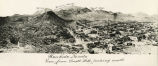
10
25
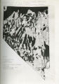
50
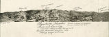
100
200
Sort by Relevance
Sort by Title A-Z
Sort by Title Z-A
Sort by Date Ascending
Sort by Date Descending
Sort by Last Modified Ascending
Sort by Last Modified Descending
Title
Date
Type
51
Photographic copy of List of Mining Districts; 1912-1914
1914
Image
52
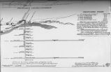
Photographic copy of U.S. Geologic Survey Publication Geological Chart of the State of Nevada, with location of Ophir Mines drawn in
1908; 1909; 1910; 1911; 1912
Image
53
Photographic copy of U.S. Geologic Survey Publication Geological Chart of the State of Nevada; Showing location of Fairview, Churchill County, Nevada
Image
54
Prospective work - construction and installations on Ophir Mines;1910-1914
1908; 1909; 1910; 1911; 1912
Image
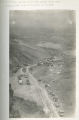
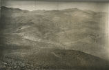
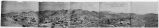
55
Rawhide, Nevada, Mineral County; view from Hooligan Hill looking North; Nevada's phenominal gold-silver camp producing $50,000 gold and silver per month
1908; 1909; 1910; 1911; 1912
Image
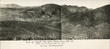
56
Rawhide, Nevada, view from Grutt Hill looking South
1908; 1909; 1910; 1911; 1912
Image
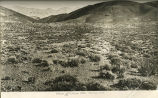
57
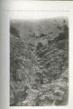
Rock Canyon near Nevada Hills Mine; big strike was made here in 1908
1908; 1909; 1910; 1911; 1912
Image
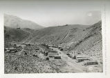
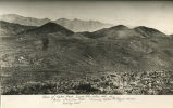
58
Town of Fairview looking North from Nevada Hills Mine; showing (Old) Town of Fairview in distance
1908; 1909; 1910; 1911; 1912
Image
59
The town of Fairview, Nevada (New Town) looking South towards the hill and mine
1908; 1909; 1910; 1911; 1912
Image
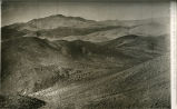
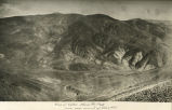
60
View looking West and South from Summit of Olive Mountain.
1908; 1909; 1910; 1911; 1912
Image
61
View looking West from Summit of Olive Mountain
1908; 1909; 1910; 1911; 1912
Image
62
View of Eagle Mountain Mines (Royal Mines); looking Northeast
1908; 1909; 1910; 1911; 1912
Image
63
View of Eagle Mountain, Ophir Peak and Olive Mountain
1908; 1909; 1910; 1911; 1912
Image
64
View of Eagle Mountain, Ophir Peak, Olive Mountain, etc; from summit of Monitor Hill; looking North and East
1908; 1909; 1910; 1911; 1912
Image
65
View of Ilump - Royal Mines; looking Southeast
1908; 1909; 1910; 1911; 1912
Image
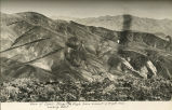
66
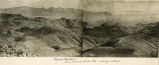
View of Mountains from Summit Olive Mountain looking Southeast
1908; 1909; 1910; 1911; 1912
Image
67
View of Mountains looking south east from summit of Eagle Mountain
1908; 1909; 1910; 1911; 1912
Image
68
View of Olive Mountain looking East
1908; 1909; 1910; 1911; 1912
Image
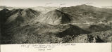
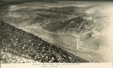
69
View of Ophir Mines and Peak from near summit of Olive Mountain
1908; 1909; 1910; 1911; 1912
Image
70
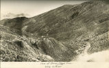
View of Ophir Mines and Peak from summit of Eagle Mountain; looking East
1908; 1909; 1910; 1911; 1912
Image
71
View of Ophir Mines from summit of Ophir Peak; Olive and Eagle Mountains; looking West
1908; 1909; 1910; 1911; 1912
Image
72
View of Ophir Peak, Eagle Mountain, Olive Mountain, etc; from Chieftan Hill showing Ophir and Royal Mines; looking East
1908; 1909; 1910; 1911; 1912
Image
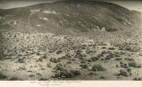
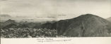
73
View of Rawhide Nevada - from Hooligan Hill looking North and East
1908; 1909; 1910; 1911; 1912
Image
74
View of Royal Mines from summit Olive Mountain; looking Northeast
1908; 1909; 1910; 1911; 1912
Image
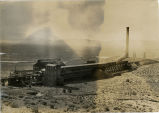
75
Wabuska Smelter
1908; 1909; 1910; 1911; 1912
Image
51
-
75
of
77
<
1
2
3
4
>