Home
Browse
Ask Us
Chat
Harmful Language Statement
Log in
Photo Archives
Advanced Search
About
Over 70,000 photos covering a variety of topics from Marriott Library Special Collections
Year
1930
1931
1932
1933
1934
1935
1936
1937
1938
1939
1940
1941
1942
1943
1944
1945
1946
1947
1948
1949
1950
1951
1952
1953
1954
1955
1956
1957
1958
1959
1960
1961
1962
1963
1964
1965
1966
1967
1968
1969
1970
TO
1930
1931
1932
1933
1934
1935
1936
1937
1938
1939
1940
1941
1942
1943
1944
1945
1946
1947
1948
1949
1950
1951
1952
1953
1954
1955
1956
1957
1958
1959
1960
1961
1962
1963
1964
1965
1966
1967
1968
1969
1970
Type
Image
100
Format
image/jpeg
100
Collection Name
Environmental Geology in Utah
100
Filters:
Collection Name:
"Environmental Geology in Utah"
Collection:
uum_map
1
-
25
of
100
<
1
2
3
4
>
Gallery view
Number of results to display per page
10
25
50
100
200
Sort by Relevance
Sort by Title A-Z
Sort by Title Z-A
Sort by Date Ascending
Sort by Date Descending
Sort by Last Modified Ascending
Sort by Last Modified Descending
Sort by Photo Number
Title
Setname
Type
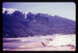
1
Flooding from snow runoff, mouth of Weber Canyon. Weber River has overtopped its normal channel banks and covers its flood plain. Periodically, structures situated on this flood plain become inundated. Note: ancient Lake Bonneville terraces may be seen on the mountain front.
uum_map
Image
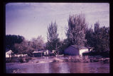
2
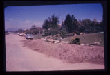
Big Cottonwood Creek flooding in Salt Lake City. Numerous houses along its banks were flooded in 1952.
uum_map
Image
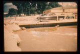
3
Sandbagging of Big Cottonwood Creek to confine its flow. Bridge was temporary, to span floodwaters.
uum_map
Image
4
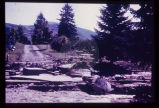
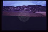
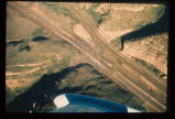
September 1970 flooding, by widespread cloudburst, of the San Juan River, seen here to occupy most of its floodplain. Bridge is only link to civilization for approximately 1,000 Navajo Indians. Note that only the left one-third of bridge has escaped attack by rising flood waters (other two-thirds appear muddy). Oblique aerial view. Most of Utah is subject to cloudburst flooding from April to September. Cloudbursts are of short duration and high intensity.
uum_map
Image
5
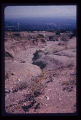
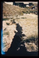
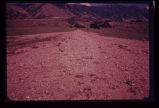
Cloudburst flood caused erosion of the North Bench in Salt Lake City. Eroded channel begins where paved street ends.
uum_map
Image
6
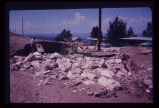
Breach of highway embankment on East Bench in Salt Lake City caused extensive damage to residential neighborhood downslope.
uum_map
Image
7
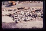
Pavement of Big Cottonwood Canyon Road, east of Salt Lake City, torn up by cloudburst flood in August 1969.
uum_map
Image
8
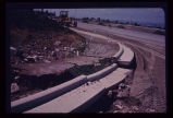
Damage to newly laid curb and gutter on Salt Lake City's East Bench, resulting from August 1969 cloudburst.
uum_map
Image
9
Damage to the Salt Lake City Cemetery from a flood channeled in Perry's Hollow, a normally dry drainage course.
uum_map
Image
10
Erosion of a hillside fill- more than 2 feet from a single cloudburst. Sediment is deposited at foot of slope in neighbor's back yard.
uum_map
Image
11
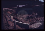
Erosion of fill placed from home construction. Deposition of material in foreground gives braided stream appearance.
uum_map
Image
12
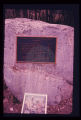
Monument to campers who lost their lives in cloudburst flood in Sheep Creek Canyon, in Flaming Gorge National Recreational Area, 1963. Note: boulder on which bronze monument has been placed is striated and polished by glacial action in the ice age.
uum_map
Image
13
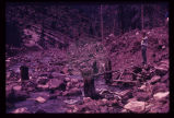
Upstream from the monument was this scene in May 1969. Broken tree trunks and picnic table (beneath feet of observer in photo) recently re-exposed from under 8 feet of debris.
uum_map
Image
14
Nose of sagebrush-covered debris pointing out into grassy valley, in Sanpete County. Debris deposit was a sharply defined mud-rock flow.
uum_map
Image
15
Mud-flow which occurred in same season in which photo was taken, in Tooele County. Cloudburst probably descended on the background watershed in the Oquirrh Range.
uum_map
Image
16
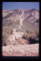
Rock-debris flow from source onto road in foreground.
uum_map
Image
17
Cone or fan of debris deposited on highway after cloudburst flood in Big Cottonwood Canyon.
uum_map
Image
18
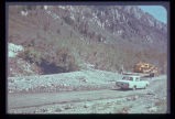
Mud-rock flow from upper steep-walled tributary canyon into Echo Canyon (Summit County) and over Interstate 80. Note that one lane of traffic has been cleared of debris. Aerial photo July 1968.
uum_map
Image
19
Mud-flow debris cleared from residence after storm on Salt Lake City's East Bench.
uum_map
Image
20
House carried on mud-flow from Davis Creek, Davis County. Historic photo, 1930. Debris covered the highway to a depth of about 6 feet.
uum_map
Image
21
Expensive new house being constructed on banks of perennial stream which is subject to flood each spring and throughout the summer. Should not a form of flood plain zoning be in effect?
uum_map
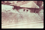
Image
22
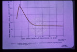
Sediment load is a factor to be considered with surface streams. This graph shows the relationship between mean annual sediment load and mean annual precipitation for the specific environment where the mean annual temperature is 40 degrees F. Other curves may be drawn for various other mean annual temperatures. Note that in this regime sediment yield is greatest at about 8 or 9 inches of precipitation. This factor must be given careful consideration when designing flood impoundment structures. The greater the sediment load the quicker the reservoir fills up.
uum_map
Image
23
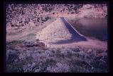
Landsliding of an abutment encroaching on the reservoir which is near its peak stage (elevation). Structures for impoundment of flood waters must be sited with strict regard for geological conditions.
uum_map
Image
24
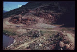
A reservoir showing the earth-fill dam and a landslide block separated from the abutment in the foreground. Opposite abutment is an ancient landslide.
uum_map
Image
25
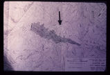
Engineering plan for a proposed reservoir in Salt Lake City. Note the anomalous contour spacing under the arrow. This indicates that the hillside has slid in the past. Construction of a reservoir here would inundate the toe of an ancient landslide and destroy the balance and stability of the weak landslide mass.
uum_map
Image
1
-
25
of
100
<
1
2
3
4
>