Home
Browse
Ask Us
Chat
Harmful Language Statement
Log in
Photo Archives
Advanced Search
About
Over 90,000 photos covering a variety of topics from Marriott Library Special Collections.
Type
Image
43
Format
image/jpeg
43
Collection
Photo Archives
43
Filters:
Collection Name:
"Environmental Geology in Utah"
Spatial Coverage:
"Utah"
26
-
50
of
43
<
1
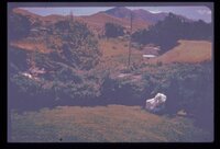
2
>
Gallery view
Number of results to display per page
10
25
50
100
200
Sort by Relevance
Sort by Title A-Z
Sort by Title Z-A
Sort by Date Ascending
Sort by Date Descending
Sort by Last Modified Ascending
Sort by Last Modified Descending
Title
Date
Type
26
Looking across a dam towards a massive ancient landslide. Recent highway construction has rejuvenated landsliding just below the spillway; note receding hillside under arrow.
Image
27
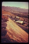
Looking downstream from the crest of the same earthfill dam (p1274n026). Note urban area at mouth of canyon.
Image
28
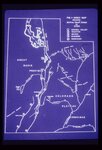
Map of Utah showing the 5 major active fault zones in the state.
Image
29
Ogden Standard Examiner newspaper photograph of mudslide encroaching into dining room.
Image
30
The old drainage below the dam through the city is now the site of numerous houses. Severe destruction would result from the dam failure.
Image
31
Party of people viewing large landslide mass. Slide plane (surface along which mass of earth moved) is evident in photo half way down the exposed wall, sloping towards the party.
Image
32
Reservoir slopes failing just upstream from dam. A failure overtopping the road would cause turbidity in the drinking water for a large city since the intake is directly downstream and in line with the current.
Image
33
Rock-debris flow from source onto road in foreground.
Image
34
Same view showing notch in cut slope, the result of a failure onto the road soon after opening to traffic (p1274n030). Landsliding is predictable.
Image
35
Steep, high, artificial fill slopes in or near the Wasatch Fault Zone. Downslope from these fills lie dense residential developments. Atop these fills are residences. How may these earth materials be expected to react to seismic vibrations?
Image
36
Surficial or shallow ground water is subject to pollution from buried solid wastes. Leaching of the wastes can occur in time. This excavation is for a land fill operation where ground water was encountered at a depth of less than 6 feet.
Image
37
Swelling of clay soil as it takes on additional moisture heaved up this garage floor and cracked it.
Image
38
These twin tanks deverge from bottom to top. Differential settling of their foundations caused this.
Image
39
This water storage reservoir has failed; it was placed improperly upon a stratum of gypsum (white layers in photo) which partially dissolved.
Image
40
Undisturbed hillside failing because of lateral and vertical erosion by creek. Debris is continuously removed from toe of sliding hillside by the creek.
Image
41
View along the highway traffic lanes and the dam abutment at the newly created cut slope.
Image
42
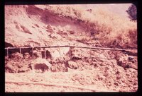
Weber Basin Job Corpsmen digging out mudslide debris from hillside house.
Image
43
Well points (small diameter water wells) used to dewater a hillside in loose sand to stabilize it after cut was made for roadway.
Image
26
-
50
of
43
<
1
2
>