Home
Browse
Ask Us
Chat
Harmful Language Statement
Log in
Photo Archives
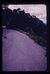
Advanced Search
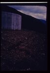
About
Over 90,000 photos covering a variety of topics from Marriott Library Special Collections.
Type
Image
43
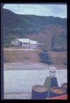
Format
image/jpeg
43
Institution
University of Utah Marriott Library
43
Collection
Photo Archives
43
Filters:
Collection Name:
"Environmental Geology in Utah"
Spatial Coverage:
"Utah"
Type:
"Image"
1
-
25
of
43
<
1
2
>
Gallery view
Number of results to display per page
10
25
50
100
200
Sort by Relevance
Sort by Title A-Z
Sort by Title Z-A
Sort by Date Ascending
Sort by Date Descending
Sort by Last Modified Ascending
Sort by Last Modified Descending
Title
Date
Type
1
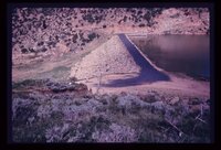
A reservoir showing the earth-fill dam and a landslide block separated from the abutment in the foreground. Opposite abutment is an ancient landslide.
Image
2
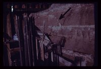
Arrow points to incipient failure of an excavation wall for a foundation for a multistory office building. Material is horizontally stratified Lake Bonneville silts and sands.
Image
3
Blasting for an interstate highway in the immediate vicinity of a dam. Concrete railing of dam appears in lower right corner. Vibrations, whether natural (earthquake) or manmade, may damage structures on sensitive foundations.
Image
4
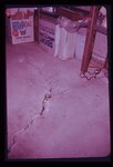
Characteristic arcuate crack pattern in basement of house. Both vertical and lateral displacement is apparent.
Image
5
The circumstances here probably make a utility trench cave-in inevitable. A perched water table is sapping fine sand from underneath a thick silt bed, leaving the latter unsupported. Failure will be too rapid for escape of a workman who may be in the trench at the wrong moment.
Image
6
Closeup of slide plane. Note deposition of white calcium carbonate by groundwater along slide plane. Arrow points to smooth, slickensided (grooved) surface on underside of sliding mass.
Image
7
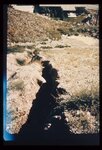
Crack down the highway centerline, showing displacement. U.S. 6 near Colton.
Image
8
Crack in soil alongside reservoir, showing subsidence. Reservoir was the only water storage facility serving several thousand people.
Image
9
Dropping of street which crossed old landslide failure plane. Note break in slope towards distance in line with fresh scarplet across street. Utility pole is seated along the slide plane.
Image
10
Erosion of a hillside fill- more than 2 feet from a single cloudburst. Sediment is deposited at foot of slope in neighbor's back yard.
Image
11
Erosion of fill placed from home construction. Deposition of material in foreground gives braided stream appearance.
Image
12
Excavation for a covered distribution reservoir is pointed out in the photo. Note that drainages have been truncated. Reservoir is in an urban area with considerable development downslope. Geologic materials comprising the site are unstable. Geologic faults are mapped bounding the site, and springs issue from excavation walls and floor.
Image
13
Expensive new house being constructed on banks of perennial stream which is subject to flood each spring and throughout the summer. Should not a form of flood plain zoning be in effect?
Image
14
Exposure of a branch of the Wasatch Fault in a sand and gravel pit along the mountain front. Amount of displacement is indeterminable from the stratigraphy exposed. Note that the fault is planar and stands out with relative resistance to the elements despite lack of cementation of the sand and gravel.
Image
15
Failure of front yard before completion of home construction in mountain subdivision.
Image
16
Failure of ground bordering on a covered distribution reservoir. Hammer provides scale on displacement scarp.
Image
17
Front end view of the slide (p1274n030).
Image
18
Hillside subdivision in landslide terrain. Terrain in background has slid in the past. Instrument for measuring ground displacement is housed in box in foreground. White rain gage sits atop instrument housing.
Image
19
Hydrograph depicting flow for the year 1945 of Utah's second largest spring, Swan Creek Spring, west of Bear Lake in northern Utah. Note the fluctuation in flow from April to September. Note also rapid response to spring snowmelt (April and May) and rainfall (June and July). The rock from which the spring issues (aquifer) is limestone. The graph illustrates the importance of controlling development on limestone terrain.
Image
20
In the same house; the ceiling is clearly distressed.
Image
21
Incipient landslide failure on subdivision road. Note characteristic arcuate configuration of ground surface, also patching along crack.
Image
22
Landslide of bedrock onto highway; a frequent problem for highway maintenance, sometimes necessitating blasting of large bedrock blocks.
Image
23
Landslide scarplet "getting closer to home" in mountain subdivision.
Image
24
Landsliding of an abutment encroaching on the reservoir which is near its peak stage (elevation). Structures for impoundment of flood waters must be sited with strict regard for geological conditions.
Image
25
Leakage through the undisturbed abutment of an earthfill dam, measured in a wooden weir.
Image
1
-
25
of
43
<
1
2
>