Home
Browse
Ask Us
Chat
Harmful Language Statement
Log in
Photo Archives
Advanced Search
About
Over 70,000 photos covering a variety of topics from Marriott Library Special Collections
Year
1930
1931
1932
1933
1934
1935
1936
1937
1938
1939
1940
1941
1942
1943
1944
1945
1946
1947
1948
1949
1950
1951
1952
1953
1954
1955
1956
1957
1958
1959
1960
1961
1962
1963
1964
1965
1966
1967
1968
1969
1970
TO
1930
1931
1932
1933
1934
1935
1936
1937
1938
1939
1940
1941
1942
1943
1944
1945
1946
1947
1948
1949
1950
1951
1952
1953
1954
1955
1956
1957
1958
1959
1960
1961
1962
1963
1964
1965
1966
1967
1968
1969
1970
Type
Image
6
Format
image/jpeg
6
Collection Name
Environmental Geology in Utah
6
Filters:
Collection Name:
"Environmental Geology in Utah"
Collection:
"uum_map"
Year End:
1969
1
-
25
of
6
Gallery view
Number of results to display per page
10
25
50
100
200
Sort by Relevance
Sort by Title A-Z
Sort by Title Z-A
Sort by Date Ascending
Sort by Date Descending
Sort by Last Modified Ascending
Sort by Last Modified Descending
Sort by Photo Number
Title
Collection Number And Name
Photo Number
1
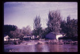
Big Cottonwood Creek flooding in Salt Lake City. Numerous houses along its banks were flooded in 1952.
P1274 Environmental Geology and Geologic Hazards in Utah Photograph Collection
p1274n002
2
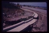
Pavement of Big Cottonwood Canyon Road, east of Salt Lake City, torn up by cloudburst flood in August 1969.
P1274 Environmental Geology and Geologic Hazards in Utah Photograph Collection
p1274n007
3
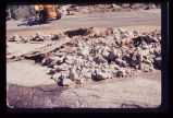
Damage to newly laid curb and gutter on Salt Lake City's East Bench, resulting from August 1969 cloudburst.
P1274 Environmental Geology and Geologic Hazards in Utah Photograph Collection
p1274n008
4
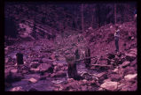
Upstream from the monument was this scene in May 1969. Broken tree trunks and picnic table (beneath feet of observer in photo) recently re-exposed from under 8 feet of debris.
P1274 Environmental Geology and Geologic Hazards in Utah Photograph Collection
p1274n013
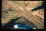
5
Mud-rock flow from upper steep-walled tributary canyon into Echo Canyon (Summit County) and over Interstate 80. Note that one lane of traffic has been cleared of debris. Aerial photo July 1968.
P1274 Environmental Geology and Geologic Hazards in Utah Photograph Collection
p1274n018
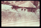
6
House carried on mud-flow from Davis Creek, Davis County. Historic photo, 1930. Debris covered the highway to a depth of about 6 feet.
P1274 Environmental Geology and Geologic Hazards in Utah Photograph Collection
p1274n020
1
-
25
of
6