Home
Browse
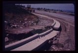
Ask Us
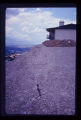
Chat
Harmful Language Statement
Log in
Photo Archives
Advanced Search
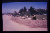
About
Over 70,000 photos covering a variety of topics from Marriott Library Special Collections
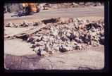
Year
1952
1953
1954
1955
1956
1957
1958
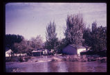
1959
1960
1961
1962
1963
1964
1965
1966
1967
1968
1969
TO
1952
1953
1954
1955
1956
1957
1958
1959
1960
1961
1962
1963
1964
1965
1966
1967
1968
1969
Type
Image
21
Format
image/jpeg
21
Collection Name
Environmental Geology in Utah
21
Filters:
Collection Name:
"Environmental Geology in Utah"
Collection:
"uum_map"
1
-
25
of
21
Gallery view
Number of results to display per page
10
25
50
100
200
Sort by Relevance
Sort by Title A-Z
Sort by Title Z-A
Sort by Date Ascending
Sort by Date Descending
Sort by Last Modified Ascending
Sort by Last Modified Descending
Sort by Photo Number
Title
Collection Number And Name
Photo Number
1
Ground subsidence leaves this fireplug supported above the sidewalk in downtown Salt Lake City.
P1274 Environmental Geology and Geologic Hazards in Utah Photograph Collection
p1274n084
2
Breach of highway embankment on East Bench in Salt Lake City caused extensive damage to residential neighborhood downslope.
P1274 Environmental Geology and Geologic Hazards in Utah Photograph Collection
p1274n006
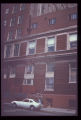
3
Multistory apartment house sitting astride the East Bench Fault of the Wasatch Fault Zone in Salt Lake City.
P1274 Environmental Geology and Geologic Hazards in Utah Photograph Collection
p1274n092
4
Damage to a house in Salt Lake City results from an unsatisfactory foundation. Note in particular the dropping of the arch over the doorway.
P1274 Environmental Geology and Geologic Hazards in Utah Photograph Collection
p1274n079
5
Landslide along a scarp of the East Bench Fault in Salt Lake City. No earth tremor is known to have triggered this slide, but an earthquake could trigger similar slides, given similar geologic conditions.
P1274 Environmental Geology and Geologic Hazards in Utah Photograph Collection
p1274n099
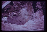
6
Branch of the Wasatch Fault exposed in utility trench excavation in Salt Lake City. Hammer and field book are at the same stratigraphic horizon, indicating a displacement of 2 1/2 feet in late mudflow deposits, just below the ground surface.
P1274 Environmental Geology and Geologic Hazards in Utah Photograph Collection
p1274n096
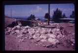
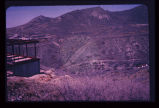
7
Closer view of slide cracks in high fill in Salt Lake City subdivision. Note housing density downslope.
P1274 Environmental Geology and Geologic Hazards in Utah Photograph Collection
p1274n061
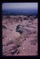
8
Cloudburst flood caused erosion of the North Bench in Salt Lake City. Eroded channel begins where paved street ends.
P1274 Environmental Geology and Geologic Hazards in Utah Photograph Collection
p1274n005
9
Damage to the Salt Lake City Cemetery from a flood channeled in Perry's Hollow, a normally dry drainage course.
P1274 Environmental Geology and Geologic Hazards in Utah Photograph Collection
p1274n009
10
Pavement of Big Cottonwood Canyon Road, east of Salt Lake City, torn up by cloudburst flood in August 1969.
P1274 Environmental Geology and Geologic Hazards in Utah Photograph Collection
p1274n007
11
Groundwater, boiling up sand, at depth of a few feet in Sugarhouse, Salt Lake City, revealed by foundation excavation. Water probably arises along East Bench branch of the Wasatch Fault.
P1274 Environmental Geology and Geologic Hazards in Utah Photograph Collection
p1274n065
12
Damage to a major edifice in Salt Lake City resulted from differential settling of the two portions of the building. Arrow points to zone of distress which extends to foundation level. Note that window frames are askew.
P1274 Environmental Geology and Geologic Hazards in Utah Photograph Collection
p1274n083
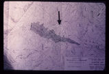
13
Map of portion of the Wasatch Front showing the Wasatch Fault Zone in relation to the Salt Lake City aqueduct system (with water system facilities as projected into the 20th Century). Map illustrates severity of the earthquake problem in urban Utah.
P1274 Environmental Geology and Geologic Hazards in Utah Photograph Collection
p1274n095
14
Engineering plan for a proposed reservoir in Salt Lake City. Note the anomalous contour spacing under the arrow. This indicates that the hillside has slid in the past. Construction of a reservoir here would inundate the toe of an ancient landslide and destroy the balance and stability of the weak landslide mass.
P1274 Environmental Geology and Geologic Hazards in Utah Photograph Collection
p1274n025
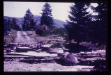
15
Mud-flow debris cleared from residence after storm on Salt Lake City's East Bench.
P1274 Environmental Geology and Geologic Hazards in Utah Photograph Collection
p1274n019
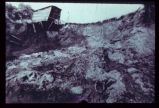
16
Slide of fill material in high, steep fill slope on Salt Lake City's North Bench.
P1274 Environmental Geology and Geologic Hazards in Utah Photograph Collection
p1274n060
17
Damage to newly laid curb and gutter on Salt Lake City's East Bench, resulting from August 1969 cloudburst.
P1274 Environmental Geology and Geologic Hazards in Utah Photograph Collection
p1274n008
18
Big Cottonwood Creek flooding in Salt Lake City. Numerous houses along its banks were flooded in 1952.
P1274 Environmental Geology and Geologic Hazards in Utah Photograph Collection
p1274n002
19
View across City Creek Canyon in Salt Lake City, showing amphitheater-like appearance of ancient landslide. Houses are short distance to left of landslide.
P1274 Environmental Geology and Geologic Hazards in Utah Photograph Collection
p1274n062
20
Closeup view of the fault shown in last slide (p1274n093).
P1274 Environmental Geology and Geologic Hazards in Utah Photograph Collection
p1274n094
21
Fault trace revealed in the foundation excavation for the building depicted in the preceding photograph (p1274n092).
P1274 Environmental Geology and Geologic Hazards in Utah Photograph Collection
p1274n093
1
-
25
of
21