Home
Browse
Ask Us
Chat
Harmful Language Statement
Log in
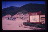
Photo Archives
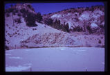
Advanced Search
About
Over 70,000 photos covering a variety of topics from Marriott Library Special Collections
Type
Image
9
Format
image/jpeg
9
Collection Name
Environmental Geology in Utah
9
Filters:
Collection Name:
"Environmental Geology in Utah"
Collection:
"uum_map"
1
-
25
of
9
Gallery view
Number of results to display per page
10
25
50
100
200
Sort by Relevance
Sort by Title A-Z
Sort by Title Z-A
Sort by Date Ascending
Sort by Date Descending
Sort by Last Modified Ascending
Sort by Last Modified Descending
Sort by Photo Number
Title
Collection Number And Name
Photo Number
1
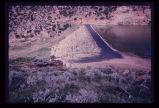
Crack in soil alongside reservoir, showing subsidence. Reservoir was the only water storage facility serving several thousand people.
P1274 Environmental Geology and Geologic Hazards in Utah Photograph Collection
p1274n077
2
Excavation for a covered distribution reservoir is pointed out in the photo. Note that drainages have been truncated. Reservoir is in an urban area with considerable development downslope. Geologic materials comprising the site are unstable. Geologic faults are mapped bounding the site, and springs issue from excavation walls and floor.
P1274 Environmental Geology and Geologic Hazards in Utah Photograph Collection
p1274n035
3
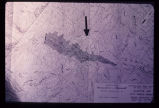
Engineering plan for a proposed reservoir in Salt Lake City. Note the anomalous contour spacing under the arrow. This indicates that the hillside has slid in the past. Construction of a reservoir here would inundate the toe of an ancient landslide and destroy the balance and stability of the weak landslide mass.
P1274 Environmental Geology and Geologic Hazards in Utah Photograph Collection
p1274n025
4
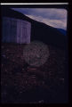
Failure of ground bordering on a covered distribution reservoir. Hammer provides scale on displacement scarp.
P1274 Environmental Geology and Geologic Hazards in Utah Photograph Collection
p1274n036
5
A reservoir showing the earth-fill dam and a landslide block separated from the abutment in the foreground. Opposite abutment is an ancient landslide.
P1274 Environmental Geology and Geologic Hazards in Utah Photograph Collection
p1274n024
6
Landsliding of an abutment encroaching on the reservoir which is near its peak stage (elevation). Structures for impoundment of flood waters must be sited with strict regard for geological conditions.
P1274 Environmental Geology and Geologic Hazards in Utah Photograph Collection
p1274n023
7
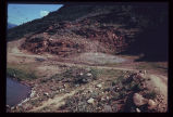
This water storage reservoir has failed; it was placed improperly upon a stratum of gypsum (white layers in photo) which partially dissolved.
P1274 Environmental Geology and Geologic Hazards in Utah Photograph Collection
p1274n076
8
Reservoir slopes failing just upstream from dam. A failure overtopping the road would cause turbidity in the drinking water for a large city since the intake is directly downstream and in line with the current.
P1274 Environmental Geology and Geologic Hazards in Utah Photograph Collection
p1274n033
9
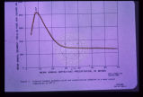
Sediment load is a factor to be considered with surface streams. This graph shows the relationship between mean annual sediment load and mean annual precipitation for the specific environment where the mean annual temperature is 40 degrees F. Other curves may be drawn for various other mean annual temperatures. Note that in this regime sediment yield is greatest at about 8 or 9 inches of precipitation. This factor must be given careful consideration when designing flood impoundment structures. The greater the sediment load the quicker the reservoir fills up.
P1274 Environmental Geology and Geologic Hazards in Utah Photograph Collection
p1274n022
1
-
25
of
9