Home
Browse
Ask Us
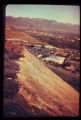
Chat
Harmful Language Statement
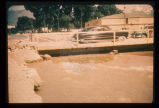
Log in
Photo Archives
Advanced Search
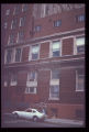
About
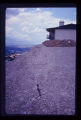
Over 70,000 photos covering a variety of topics from Marriott Library Special Collections
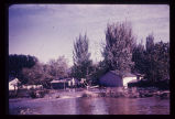
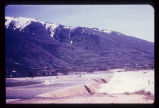
Year
1952
TO
1952
Type
Image
10
Format
image/jpeg
10
Collection Name
Environmental Geology in Utah
10
Filters:
Collection Name:
"Environmental Geology in Utah"
Collection:
"uum_map"
1
-
25
of
10
Gallery view
Number of results to display per page
10
25
50
100
200
Sort by Relevance
Sort by Title A-Z
Sort by Title Z-A
Sort by Date Ascending
Sort by Date Descending
Sort by Last Modified Ascending
Sort by Last Modified Descending
Sort by Photo Number
Title
Collection Number And Name
Photo Number
1
Closer view of slide cracks in high fill in Salt Lake City subdivision. Note housing density downslope.
P1274 Environmental Geology and Geologic Hazards in Utah Photograph Collection
p1274n061
2
Fault trace revealed in the foundation excavation for the building depicted in the preceding photograph (p1274n092).
P1274 Environmental Geology and Geologic Hazards in Utah Photograph Collection
p1274n093
3
Slide of fill material in high, steep fill slope on Salt Lake City's North Bench.
P1274 Environmental Geology and Geologic Hazards in Utah Photograph Collection
p1274n060
4
Multistory apartment house sitting astride the East Bench Fault of the Wasatch Fault Zone in Salt Lake City.
P1274 Environmental Geology and Geologic Hazards in Utah Photograph Collection
p1274n092
5
Sandbagging of Big Cottonwood Creek to confine its flow. Bridge was temporary, to span floodwaters.
P1274 Environmental Geology and Geologic Hazards in Utah Photograph Collection
p1274n003
6
Big Cottonwood Creek flooding in Salt Lake City. Numerous houses along its banks were flooded in 1952.
P1274 Environmental Geology and Geologic Hazards in Utah Photograph Collection
p1274n002
7
Hillside subdivision in landslide terrain. Terrain in background has slid in the past. Instrument for measuring ground displacement is housed in box in foreground. White rain gage sits atop instrument housing.
P1274 Environmental Geology and Geologic Hazards in Utah Photograph Collection
p1274n063
8
Damage to a major edifice in Salt Lake City resulted from differential settling of the two portions of the building. Arrow points to zone of distress which extends to foundation level. Note that window frames are askew.
P1274 Environmental Geology and Geologic Hazards in Utah Photograph Collection
p1274n083
9
Steep, high, artificial fill slopes in or near the Wasatch Fault Zone. Downslope from these fills lie dense residential developments. Atop these fills are residences. How may these earth materials be expected to react to seismic vibrations?
P1274 Environmental Geology and Geologic Hazards in Utah Photograph Collection
p1274n100
10
Flooding from snow runoff, mouth of Weber Canyon. Weber River has overtopped its normal channel banks and covers its flood plain. Periodically, structures situated on this flood plain become inundated. Note: ancient Lake Bonneville terraces may be seen on the mountain front.
P1274 Environmental Geology and Geologic Hazards in Utah Photograph Collection
p1274n001
1
-
25
of
10