Home
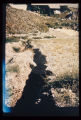
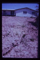
Browse
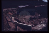
Ask Us
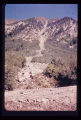
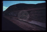
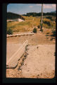
Chat
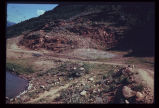
Harmful Language Statement
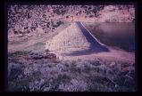
Log in
Photo Archives
Advanced Search
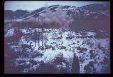
About
Over 70,000 photos covering a variety of topics from Marriott Library Special Collections
Type
Image
43
Format
image/jpeg
43
Collection Name
Environmental Geology in Utah
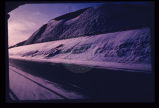
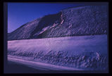
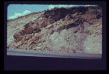
43
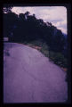
Filters:
Collection Name:
"Environmental Geology in Utah"
Collection:
"uum_map"
Spatial Coverage:
"Utah"
Type:
"Image"
1
-
25
of
43
<
1
2
>
Gallery view
Number of results to display per page
10
25
50
100
200
Sort by Relevance
Sort by Title A-Z
Sort by Title Z-A
Sort by Date Ascending
Sort by Date Descending
Sort by Last Modified Ascending
Sort by Last Modified Descending
Sort by Photo Number
Title
Collection Number And Name
Photo Number
1
Erosion of a hillside fill- more than 2 feet from a single cloudburst. Sediment is deposited at foot of slope in neighbor's back yard.
P1274 Environmental Geology and Geologic Hazards in Utah Photograph Collection
p1274n010
2
Erosion of fill placed from home construction. Deposition of material in foreground gives braided stream appearance.
P1274 Environmental Geology and Geologic Hazards in Utah Photograph Collection
p1274n011
3
Rock-debris flow from source onto road in foreground.
P1274 Environmental Geology and Geologic Hazards in Utah Photograph Collection
p1274n016
4
Expensive new house being constructed on banks of perennial stream which is subject to flood each spring and throughout the summer. Should not a form of flood plain zoning be in effect?
P1274 Environmental Geology and Geologic Hazards in Utah Photograph Collection
p1274n021
5
Landsliding of an abutment encroaching on the reservoir which is near its peak stage (elevation). Structures for impoundment of flood waters must be sited with strict regard for geological conditions.
P1274 Environmental Geology and Geologic Hazards in Utah Photograph Collection
p1274n023
6
A reservoir showing the earth-fill dam and a landslide block separated from the abutment in the foreground. Opposite abutment is an ancient landslide.
P1274 Environmental Geology and Geologic Hazards in Utah Photograph Collection
p1274n024
7
Leakage through the undisturbed abutment of an earthfill dam, measured in a wooden weir.
P1274 Environmental Geology and Geologic Hazards in Utah Photograph Collection
p1274n026
8
Looking downstream from the crest of the same earthfill dam (p1274n026). Note urban area at mouth of canyon.
P1274 Environmental Geology and Geologic Hazards in Utah Photograph Collection
p1274n027
9
The old drainage below the dam through the city is now the site of numerous houses. Severe destruction would result from the dam failure.
P1274 Environmental Geology and Geologic Hazards in Utah Photograph Collection
p1274n028
10
Looking across a dam towards a massive ancient landslide. Recent highway construction has rejuvenated landsliding just below the spillway; note receding hillside under arrow.
P1274 Environmental Geology and Geologic Hazards in Utah Photograph Collection
p1274n029
11
View along the highway traffic lanes and the dam abutment at the newly created cut slope.
P1274 Environmental Geology and Geologic Hazards in Utah Photograph Collection
p1274n030
12
Same view showing notch in cut slope, the result of a failure onto the road soon after opening to traffic (p1274n030). Landsliding is predictable.
P1274 Environmental Geology and Geologic Hazards in Utah Photograph Collection
p1274n031
13
Front end view of the slide (p1274n030).
P1274 Environmental Geology and Geologic Hazards in Utah Photograph Collection
p1274n032
14
Reservoir slopes failing just upstream from dam. A failure overtopping the road would cause turbidity in the drinking water for a large city since the intake is directly downstream and in line with the current.
P1274 Environmental Geology and Geologic Hazards in Utah Photograph Collection
p1274n033
15
Blasting for an interstate highway in the immediate vicinity of a dam. Concrete railing of dam appears in lower right corner. Vibrations, whether natural (earthquake) or manmade, may damage structures on sensitive foundations.
P1274 Environmental Geology and Geologic Hazards in Utah Photograph Collection
p1274n034
16
Excavation for a covered distribution reservoir is pointed out in the photo. Note that drainages have been truncated. Reservoir is in an urban area with considerable development downslope. Geologic materials comprising the site are unstable. Geologic faults are mapped bounding the site, and springs issue from excavation walls and floor.
P1274 Environmental Geology and Geologic Hazards in Utah Photograph Collection
p1274n035
17
Failure of ground bordering on a covered distribution reservoir. Hammer provides scale on displacement scarp.
P1274 Environmental Geology and Geologic Hazards in Utah Photograph Collection
p1274n036
18
Landslide of bedrock onto highway; a frequent problem for highway maintenance, sometimes necessitating blasting of large bedrock blocks.
P1274 Environmental Geology and Geologic Hazards in Utah Photograph Collection
p1274n039
19
Crack down the highway centerline, showing displacement. U.S. 6 near Colton.
P1274 Environmental Geology and Geologic Hazards in Utah Photograph Collection
p1274n040
20
Incipient landslide failure on subdivision road. Note characteristic arcuate configuration of ground surface, also patching along crack.
P1274 Environmental Geology and Geologic Hazards in Utah Photograph Collection
p1274n046
21
Dropping of street which crossed old landslide failure plane. Note break in slope towards distance in line with fresh scarplet across street. Utility pole is seated along the slide plane.
P1274 Environmental Geology and Geologic Hazards in Utah Photograph Collection
p1274n047
22
Landslide scarplet "getting closer to home" in mountain subdivision.
P1274 Environmental Geology and Geologic Hazards in Utah Photograph Collection
p1274n049
23
Failure of front yard before completion of home construction in mountain subdivision.
P1274 Environmental Geology and Geologic Hazards in Utah Photograph Collection
p1274n050
24
Characteristic arcuate crack pattern in basement of house. Both vertical and lateral displacement is apparent.
P1274 Environmental Geology and Geologic Hazards in Utah Photograph Collection
p1274n051
25
In the same house; the ceiling is clearly distressed.
P1274 Environmental Geology and Geologic Hazards in Utah Photograph Collection
p1274n052
1
-
25
of
43
<
1
2
>