|
|
Title | Collection Number And Name | Photo Number |
| 1 |
 |
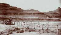
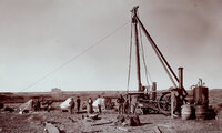
"Artesian well flowing 120 gallons of water per minute on B.D. Harshberger's farm, Bluff, Utah." | P0068 Dick Beck Photograph Collection | P0068 n 081 |
| 2 |
 |
"Bluff City artesian well number one. Struck water on November 3rd, 1908." | P0068 Dick Beck Photograph Collection | P0068 n 080 |
| 3 |
 |
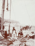
"Crasy Smith mining in San Juan River Canyon, Utah." | P0068 Dick Beck Photograph Collection | P0068 n 074 |
| 4 |
 |
"First discovery of oil in quantity on San Juan River, Utah. Oil is being poured from the bucket." | P0068 Dick Beck Photograph Collection | P0068 n 076 |
| 5 |
 |
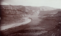
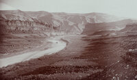
"General view of San Juan River Canyon, Utah at Mendenhall's camp. 1000 feet deep." | P0068 Dick Beck Photograph Collection | P0068 n 046 |
| 6 |
 |
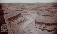
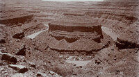
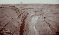
"Goose-neck Loop, San Juan River Canyon, 33 miles west of Bluff, Utah. Three miles around Loop and 1000 feet deep." | P0068 Dick Beck Photograph Collection | P0068 n 045 |
| 7 |
 |
"Grand Gulch near junction with San Juan River. 600 feet deep." | P0068 Dick Beck Photograph Collection | P0068 n 062 |
| 8 |
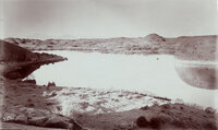 |
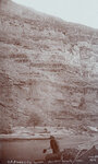
"Hermit Lake in western San Juan Co., Utah. 12 miles east of Colorado River, 1/4 mile wide and 1/2 mile long. The Henry Mountains, faintly seen, 75 miles distant." This lake was on the famous Hole-in-the-Rock trail. The natural dam failed in 1914? The lake no longer exists. | P0068 Dick Beck Photograph Collection | P0068 n 023 |
| 9 |
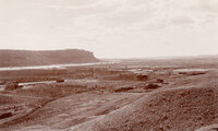 |
"Looking southwest from Bluff, Utah." | P0068 Dick Beck Photograph Collection | P0068 n 063 |
| 10 |
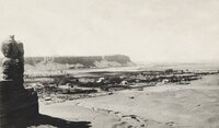 |
"Looking southwest from Bluff, Utah." | P0068 Dick Beck Photograph Collection | P0068 n 064 |
| 11 |
 |
"Mexican Hat on the San Juan River at Wilson's Camp." | P0068 Dick Beck Photograph Collection | P0068 n 065 |
| 12 |
 |
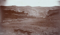
"Mexican Hat or Blanced Rock in the background of placer miners. View in Oil Basin, 25 miles west of Bluff, Utah." | P0068 Dick Beck Photograph Collection | P0068 n 072 |
| 13 |
 |
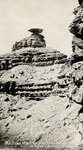
"Mokee Castle, Grand Gulch, San Juan County, Utah. Around its base and under its sheltering cliffs were found many relics of the old cliff-dwellers." | P0068 Dick Beck Photograph Collection | P0068 n 061 |
| 14 |
 |
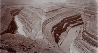
"Mound Loop, San Juan River Canyon. Scene in oil field 30 miles west of Bluff, Utah. Two miles around loop and 800 feet deep." | P0068 Dick Beck Photograph Collection | P0068 n 044 |
| 15 |
 |
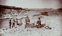
"Placer mining at foot of Honaker Trail in San Juan Canyon, Utah." | P0068 Dick Beck Photograph Collection | P0068 n 073 |
| 16 |
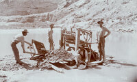 |
"Placer mining on San Juan River near Bluff, Utah." | P0068 Dick Beck Photograph Collection | P0068 n 071 |
| 17 |
 |
"Raplee's placer mining works in Oil Basin, 25 miles west of Bluff, Utah." | P0068 Dick Beck Photograph Collection | P0068 n 075 |
| 18 |
 |
"San Juan Oil Basin at Raplee's Camp. Lime Ridge Dome in background." | P0068 Dick Beck Photograph Collection | P0068 n 077 |
| 19 |
 |
"San Juan Oil Basin at Raplee's Camp. Lime Ridge Dome in background." | P0068 Dick Beck Photograph Collection | P0068 n 078 |
| 20 |
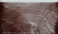 |
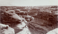
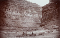
"San Juan River Canyon at Honaker Trail - 1500 Feet deep." | P0068 Dick Beck Photograph Collection | P0068 n 047 |
| 21 |
 |
"San Juan River Canyon at Mendenhall Loop. 1000 feet deep. Alhambra Rock in the distance. Eruptive and 450 feet high, 600 feet long and 90 feet wide." | P0068 Dick Beck Photograph Collection | P0068 n 048 |
| 22 |
 |
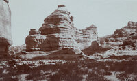
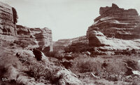
"Some rocks, Bluff, Utah. Blue lime forms the background while deep shaded parts are red lime ot trias rocks. View from San Juan Oil Field." | P0068 Dick Beck Photograph Collection | P0068 n 024 |
| 23 |
 |
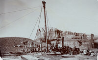
"The first Goodridge Oil Well. Oil struck March 4, 1908." | P0068 Dick Beck Photograph Collection | P0068 n 079 |
| 24 |
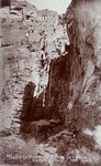 |
"Trails to Honaker's Camp, San Juan Canyon, Utah." | P0068 Dick Beck Photograph Collection | P0068 n 068 |
| 25 |
 |
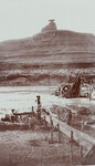
"Victoria Camp, Grand Gulch, San Juan County, Utah. Queen Vic's profiled is seen on top of cliff, right side." | P0068 Dick Beck Photograph Collection | P0068 n 060 |