|
|
Title | Collection Number And Name | Photo Number |
| 1 |
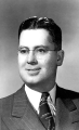 |
Gordon Miller, University of Utah faculty | P0305 University of Utah Archives Photograph Collection - A-Fa. | A-Fa.MillerGordon. |
| 2 |
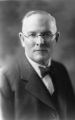 |
George Thomas, University of Utah president | P0305 University of Utah Archives Photograph Collection - A-Fa. Presidents | A-Fa.Thomas. |
| 3 |
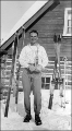 |
Junior Bounous holding an award. | P0004 Wasatch Mountain Club Photograph Collection | P0004n0017 |
| 4 |
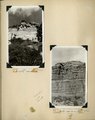 |
Herbert E. Gregory Book 11: Colorado Plateau, 1938-1942 | P0013 Herbert E. Gregory Photograph Collection | P0013n11 |
| 5 |
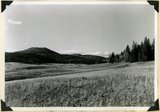
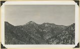
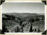 |
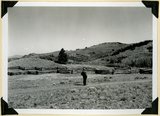
Summit Ridge. View looking south across Braffitts Canyon. Iron County, UT | P0013 Herbert E. Gregory Photograph Collection | P0013n11_167_2788 |
| 6 |
 |
Summit Ridge. Undissected highland 9000 feet near head of Summit Canyon, Iron County | P0013 Herbert E. Gregory Photograph Collection | P0013n11_167_2789 |
| 7 |
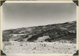
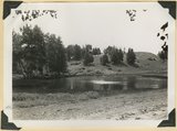 |
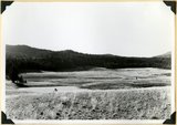
Summit Ridge. Pond supplied chiefly by melting snow. Iron County | P0013 Herbert E. Gregory Photograph Collection | P0013n11_168_2790 |
| 8 |
 |
Summit Ridge. Pond supplied chiefly by melting snow. Iron County | P0013 Herbert E. Gregory Photograph Collection | P0013n11_168_2791 |
| 9 |
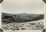
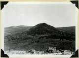 |
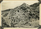
Sugar loaf on outlier of Markagunt Plateau on divide between Parowan and Coal Creek drainage areas. Iron County | P0013 Herbert E. Gregory Photograph Collection | P0013n11_169_2792 |
| 10 |
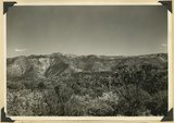
 |
Surface of Kolob Terrace near Pryor Knoll, Iron County | P0013 Herbert E. Gregory Photograph Collection | P0013n11_169_2793 |
| 11 |
 |
Westward tilting Moenkopi strata; Timpoweap, lower red, Virgin and Shnabkaib members. Mouth of Kanarra Canyon. Iron Co, UT | P0013 Herbert E. Gregory Photograph Collection | P0013n11_170_2794 |
| 12 |
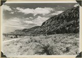 |
Hurricane Cliffs looking north across mouth of Swayne Creek. Iron County | P0013 Herbert E. Gregory Photograph Collection | P0013n11_170_2795 |
| 13 |
 |
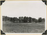
Sidney Valley near head of Castle Creek. Ponds and kame-like accumulation resulting from glaciation. Iron County, UT | P0013 Herbert E. Gregory Photograph Collection | P0013n11_171_2796 |
| 14 |
 |
Sidney Valley near head of Castle Creek. Ponds and kame-like accumulation resulting from glaciation. Iron County, UT | P0013 Herbert E. Gregory Photograph Collection | P0013n11_171_2797 |
| 15 |
 |
Surface of Kolob Terrace near head of Crystal Creek. Developed on Tropic shale | P0013 Herbert E. Gregory Photograph Collection | P0013n11_172_2798 |
| 16 |
 |
Panorama. Surface of Kolob Terrace near the head of Kolob Creek. Iron County, UT | P0013 Herbert E. Gregory Photograph Collection | P0013n11_172_2799 |
| 17 |
 |
Panorama. Surface of Kolob Terrace near the head of Kolob Creek. Iron County, UT | P0013 Herbert E. Gregory Photograph Collection | P0013n11_173_2800 |
| 18 |
 |
View looking north from near head of South Creek across Coal Canyon, Iron County, UT | P0013 Herbert E. Gregory Photograph Collection | P0013n11_173_2801 |
| 19 |
 |
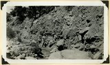
Log Hollow fault (Cretaceous), Kaiparowits formation, on upthrown side (middle and right) in contact with Tertiary (left). Estimated displacement 700 feet. Bowery Canyon, Iron County, UT. 1942 | P0013 Herbert E. Gregory Photograph Collection | P0013n11_174_2802 |
| 20 |
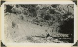 |
Recent trenching of valley fill of stratified sands and clay, upper part of Spring Creek Canyon, Iron County, UT, 1942 | P0013 Herbert E. Gregory Photograph Collection | P0013n11_174_2803 |
| 21 |
 |
Recent trenching of valley fill of stratified sands and clay, upper part of Spring Creek Canyon, Iron County, UT, 1942 | P0013 Herbert E. Gregory Photograph Collection | P0013n11_175_2804 |
| 22 |
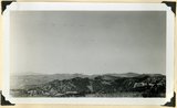 |
Surface of the Piute Highlands looking north from Mithcell Ridge, Iron County, UT, 1942 | P0013 Herbert E. Gregory Photograph Collection | P0013n11_175_2805 |
| 23 |
 |
Pond confined by a glacial moraine. Dry Lakes road, Iron County, UT, 1942 | P0013 Herbert E. Gregory Photograph Collection | P0013n11_176_2806 |
| 24 |
 |
Kaiparowits formation (Cretaceous) overlain by the Wasatch Tertiary. Bowery Canyon, Iron County, 1942 | P0013 Herbert E. Gregory Photograph Collection | P0013n11_176_2807 |
| 25 |
 |
Kaiparowits formation (Cretaceous) overlain by the Wasatch Tertiary. Bowery Canyon, Iron County, 1942 | P0013 Herbert E. Gregory Photograph Collection | P0013n11_177_2808 |