Home
Browse
Ask Us
Chat
Harmful Language Statement
Log in
Advanced Search
Year
1840
1841
1842
1843
1844
1845
1846
1847
1848
1849
1850
1851
1852
1853
1854
1855
1856
1857
1858
1859
1860
1861
1862
1863
1864
1865
1866
1867
1868
1869
1870
1871
1872
1873
1874
1875
1876
1877
1878
1879
1880
1881
1882
1883
1884
1885
1886
1887
1888
1889
1890
1891
1892
1893
1894
1895
1896
1897
1898
1899
1900
1901
1902
1903
1904
1905
1906
1907
1908
1909
1910
1911
1912
1913
1914
1915
1916
1917
1918
1919
1920
1921
1922
1923
1924
1925
1926
1927
1928
1929
1930
1931
1932
1933
1934
1935
1936
1937
1938
1939
1940
1941
1942
1943
1944
1945
1946
1947
1948
1949
1950
1951
1952
1953
1954
1955
1956
1957
1958
1959
1960
1961
1962
1963
1964
1965
1966
1967
1968
1969
1970
1971
1972
1973
1974
1975
1976
1977
1978
1979
1980
1981
1982
1983
1984
1985
1986
1987
1988
1989
1990
1991
1992
1993
1994
1995
1996
1997
1998
1999
2000
2001
2002
2003
2004
2005
2006
2007
2008
TO
1840
1841
1842
1843
1844
1845
1846
1847
1848
1849
1850
1851
1852
1853
1854
1855
1856
1857
1858
1859
1860
1861
1862
1863
1864
1865
1866
1867
1868
1869
1870
1871
1872
1873
1874
1875
1876
1877
1878
1879
1880
1881
1882
1883
1884
1885
1886
1887
1888
1889
1890
1891
1892
1893
1894
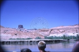
1895
1896
1897
1898
1899
1900
1901
1902
1903
1904
1905
1906
1907
1908
1909
1910
1911
1912
1913
1914
1915
1916
1917
1918
1919
1920
1921
1922
1923
1924
1925
1926
1927
1928
1929
1930
1931
1932
1933
1934
1935
1936
1937
1938
1939
1940
1941
1942
1943
1944
1945
1946
1947
1948
1949
1950
1951
1952
1953
1954
1955
1956
1957
1958
1959
1960
1961
1962
1963
1964
1965
1966
1967
1968
1969
1970
1971
1972
1973
1974
1975
1976
1977
1978
1979
1980
1981
1982
1983
1984
1985
1986
1987
1988
1989
1990
1991
1992
1993
1994
1995
1996
1997
1998
1999
2000
2001
2002
2003
2004
2005
2006
2007
2008
Type
Image
1,299
Image/StillImage
100
Text
53
Sound
2
Format
image/jpeg
1,395
application/pdf
115
video/mp4
2
Collection
Beckwith Photograph Collection
9
Glen Canyon
1
Hiram B. Clawson Papers
1
Mormon Settlement in Arizona
2
Photo Archives
1,304
UAIDA Main Collection
2
Utah Humanities Research Foundation
2
Utah Quilt Heritage Records
44
Utah River Running Photo Archives
142
Western Soundscape
2
Western Waters NEH
2
Westminster College Photographs
2
More
Filters:
Spatial Coverage:
"Kane County (Utah)"
226
-
250
of
1,513
<
5
6
7
8
9
10
11
12
13
14
>
Gallery view
Number of results to display per page
10
25
50
100
200
Sort by Relevance
Sort by Title A-Z
Sort by Title Z-A
Sort by Date Ascending
Sort by Date Descending
Sort by Last Modified Ascending
Sort by Last Modified Descending
Title
Date
Type
Setname
226
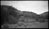
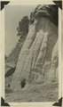
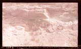
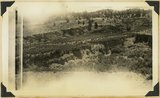
Cliff side and shed near Orderville
Image
uum_map
227
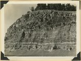
Cliffs at Cannonville. Banded muds below Dakota. Lower Wahweap of Moore. Kane County, UT. 1922
1922
Image
uum_map
228
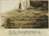
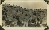
Cliffs of McElmo formation 2+ miles east of Warm Creek, Kane County, Utah. June 8, 1915.
1915
Image
uum_map
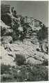
229
Cliffs of Tertiary limestone under rim of Paunsaugunt Plateau at a point about 7 miles NE of Alton, Kane County, Utah, in 1922.
1922
Image
uum_map
230
Cliffs of Waweap capped with Dakota. East side Dry Valley looking North. Top of Kaiparowits Plateau in distance. Kane County, UT. 1924
1924
Image
uum_map
231
Coal in the Dakota or basal Tropic; Coal hill east side Meadow Brook. Kane County, UT
1937
Image
uum_map
232
Colonial Ladies quilt, by Clorene Roundy Hoyt
1950; 1951; 1952; 1953; 1954; 1955; 1956; 1957; 1958; 1959
Text
uum_uqhr
233
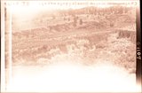
Coming into Kane
1962
uum_map_rr
234
Coming into Kane
1962
uum_map_rr
235
Coming into Kane
1962
uum_map_rr
236
Consolidated Pleistocene? Valley fill, gulch east of Mt. Carmel Junction. View taken standing on Carmel limestone. Kane County, Utah, 1932.
1934
Image
uum_map
237
Consolidated river gravel (Wisconsin age?) overlying eroded Entrada(?) 300 feet above Paria River 2 miles south of Cannonville, Kane County, UT, 1939
1939
Image
uum_map
238
Contact between Kaibab and Moenkopi in Kaibab (Buckskin) Gulch
1922
Image
uum_map
239
Contact Carmel limestone (top) and Navajo (bottom), between them calcareous and argillaceous shales. Kane County, UT
1937; 1938
Image
uum_map
240
Contact Entrada (?) bottom and Summerville (?) Paria River 6± miles south of Cannonville, Garfield County, Utah, 1932.
1932
Image
uum_map
241
Contact Jurassic and consolidated valley fill (Pleistocene?) in gulch east of Mt. Carmel Junction. Kane County, Utah, 1932.
1934
Image
uum_map
242
Contact Jurassic and consolidated valley fill (Pleistocene?) in gulch east of Mt. Carmel Junction. Kane County, Utah, 1932.
1934
Image
uum_map
243
Contact of Kayenta formation (foreground) and Navajo sandstone Park Wash above the mouth of Five Pines Wash. Kane County, UT. 1943
1943
Image
uum_map
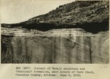
244
Contact of Navajo sandstone and "Sentinal" formation, east branch of Warm Creek, Coconino County, Arizona.. June, 1915.
1915
Image
uum_map
245
Contact Wingate and Kayenta formation, branch of Kitchen Canyon east of White Cone, Kane County, Utah, 1938.
1938
Image
uum_map
246
Contact, Carmel & Navajo Skutumpah
1936
Image
uum_map
247
Contact, Carmel and Navajo Skutumpah, 1936.
1936
Image
uum_map
248
Cooling off in Kane Creek
1962
uum_map_rr
249
Coral Pink Sand Dunes
1985-05-10; 1985-05-11; 1985-05-12
Image
uum_map
250
Coral Pink Sand Dunes
1985-05-10; 1985-05-11; 1985-05-12
Image
uum_map
226
-
250
of
1,513
<
5
6
7
8
9
10
11
12
13
14
>