|
|
Title | Collection Number And Name | Photo Number |
| 101 |
 |
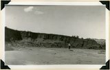
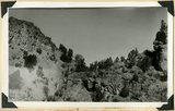
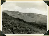
Ancient talus (right foreground) and talus now forming at base of Kinesava mountain, Zion National Park, Washington County, UT, 1939 | P0013 Herbert E. Gregory Photograph Collection | P0013n11_041_2590 |
| 102 |
 |
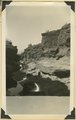
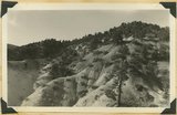
Bed of little Creek, sunk 10 feet to 40 feet into alluvium since 1890, Kane County, UT, 1939 | P0013 Herbert E. Gregory Photograph Collection | P0013n11_041_2591 |
| 103 |
 |
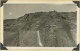
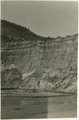
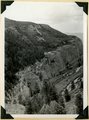
Wasatch cliff (top, Kaiparowits (slope) and upper beds of Wahweap formations, Wilson Point, Sunset Cliffs, head of Hillsdale Canyon, Garfield County, UT, 1939 | P0013 Herbert E. Gregory Photograph Collection | P0013n11_042_2592 |
| 104 |
 |
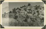
Contact of old and recent basalt flows near head of Gould Canyon, Washington County, UT, 1939 | P0013 Herbert E. Gregory Photograph Collection | P0013n11_042_2593 |
| 105 |
 |
Edge of basalt flow over eroded Moenkopi along highway west of Grafton, Washington County, UT, 1939 | P0013 Herbert E. Gregory Photograph Collection | P0013n11_043_2594 |
| 106 |
 |
Carmel formation in Mineral Gulch. Typical arrangement of shaly and massive beds, Kane County, UT. 1939 | P0013 Herbert E. Gregory Photograph Collection | P0013n11_043_2595 |
| 107 |
 |
Winsor formation type locality, Winsor Cove, branch of Muddy Brook. Overlying Dakota at top (right). Kane County, UT. 1939 | P0013 Herbert E. Gregory Photograph Collection | P0013n11_044_2596 |
| 108 |
 |
Tropic shale, Muddy Brook 6 miles above its mouth, Kane County, UT, 1939 | P0013 Herbert E. Gregory Photograph Collection | P0013n11_044_2597 |
| 109 |
 |
Base of Straight Cliffs formation (Cretaceous) at Orderville. Tropic shale forms slope at bottom. Kane County, UT, 1939 | P0013 Herbert E. Gregory Photograph Collection | P0013n11_045_2598 |
| 110 |
 |
Gypsum of Curtis formation (cliff at top) and Entrada (slope), Short Branch of Parunuweap 1 mile south of Mount Carmel, Kane County, UT. 1939 | P0013 Herbert E. Gregory Photograph Collection | P0013n11_046_2599 |
| 111 |
 |
Carmel (bottom), Entrada (slope), Curtis (cliff of gypsum) and Winsor formation (top slope), Meadow Brook Canyon, Kane County, UT, 1939 | P0013 Herbert E. Gregory Photograph Collection | P0013n11_046_2600 |
| 112 |
 |
Fault in short canyon east of road one mile south of Mt. Carmel Junction. Carmel strata capped with old consolidated gravel, Kane County, UT, 1939 | P0013 Herbert E. Gregory Photograph Collection | P0013n11_047_2601 |
| 113 |
 |
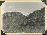
Carmel formation (cliff) at head of Flume Canyon upthrow (east) side of Sevier fault which trends northeasterly. Cretaceous formations (background) at level of Jurassic. Kane County, UT. 1939 | P0013 Herbert E. Gregory Photograph Collection | P0013n11_048_2603 |
| 114 |
 |
Carmel formation in branch of Flume Canyon. About half of total shown. Kane County, UT. 1939 | P0013 Herbert E. Gregory Photograph Collection | P0013n11_048_2604 |
| 115 |
 |
Entrada formation. Gypsiferous Curtis at top. Near mouth of Crystal Creek, Washington County, UT, 1939 | P0013 Herbert E. Gregory Photograph Collection | P0013n11_049_2605 |
| 116 |
 |
Johnson Creek. Old alluvial fill trenched 40 feet since 1915, Kane County, Utah, 1939 | P0013 Herbert E. Gregory Photograph Collection | P0013n11_049_illus1205 |
| 117 |
 |
Straight Cliff sandstone top, Tropic Dakota and Winsor formation in middle and foreground, covered by land slide. Basalt at tight and on top. Head of Oak Creek, Kane County, UT, 1939 | P0013 Herbert E. Gregory Photograph Collection | P0013n11_050_2606 |
| 118 |
 |
Fossiliferous Straight Cliffs sandstone, Kolob Terrace, Washington County, UT, 1939 | P0013 Herbert E. Gregory Photograph Collection | P0013n11_050_2607 |
| 119 |
 |
Cougar Mountain fault. Springdale member of Chinle (lower left) abutting against base of Navajo (lower right), Washington County, UT, 1939 | P0013 Herbert E. Gregory Photograph Collection | P0013n11_051_2608 |
| 120 |
 |
Frepit Knoll, volcano (left), wall of Navajo sandstone capped by Carmel limestone (center), lava coated with vegetation (foreground), Washington County, UT, 1939 | P0013 Herbert E. Gregory Photograph Collection | P0013n11_051_2609 |
| 121 |
 |
Winsor formation type locality, Winsor Cove, Kane County, UT, 1939 | P0013 Herbert E. Gregory Photograph Collection | P0013n11_052_2610 |
| 122 |
 |
Winsor formation type locality, Winsor Cove, Kane County, UT, 1939 | P0013 Herbert E. Gregory Photograph Collection | P0013n11_052_2611 |
| 123 |
 |
Head of Oak Valley area of landslides from Straight Cliffs sandstone (background), Tropic shale (foreground), Washington County, UT, 1939 | P0013 Herbert E. Gregory Photograph Collection | P0013n11_053_2612 |
| 124 |
 |
View of Oak Valley from west. Carmel white (foreground), Tropic shale overlain by landslides (middle distance), Straight Cliffs sandstone (cliffs), Wasatch cliffs on skyline, Washington County, UT, 1939 | P0013 Herbert E. Gregory Photograph Collection | P0013n11_053_2613 |
| 125 |
 |
Camp Creek near its mouth in Hurricane Cliffs. Navajo sandstone overlain by Carmel, Entrada, Curtis and Winsor. Pine Valley mountains (right distance), Washington County, UT, 1939 | P0013 Herbert E. Gregory Photograph Collection | P0013n11_054_2614 |