Home
Browse
Ask Us
Chat
Harmful Language Statement
Log in
Photo Archives
Advanced Search
About
Over 70,000 photos covering a variety of topics from Marriott Library Special Collections
Year
1845
1846
1847
1848
1849
1850
1851
1852
1853
1854
1855
1856
1857
1858
1859
1860
1861
1862
1863
1864
1865
1866
1867
1868
1869
1870
1871
1872
1873
1874
1875
1876
1877
1878
1879
1880
1881
1882
1883
1884
1885
1886
1887
1888
1889
1890
1891
1892
1893
1894
1895
1896
1897
1898
1899
1900
1901
1902
1903
1904
1905
1906
1907
1908
1909
1910
1911
1912
1913
1914
1915
1916
1917
1918
1919
1920
1921
1922
1923
1924
1925
1926
1927
1928
1929
1930
1931
1932
1933
1934
1935
1936
1937
1938
1939
1940
1941
1942
1943
1944
1945
1946
1947
1948
1949
1950
1951
1952
1953
1954
1955
1956
1957
1958
1959
1960
1961
1962
1963
1964
1965
1966
1967
1968
1969
1970
1971
1972
1973
1974
1975
1976
1977
1978
1979
1980
TO
1845
1846
1847
1848
1849
1850
1851
1852
1853
1854
1855
1856
1857
1858
1859
1860
1861
1862
1863
1864
1865
1866
1867
1868
1869
1870
1871
1872
1873
1874
1875
1876
1877
1878
1879
1880
1881
1882
1883
1884
1885
1886
1887
1888
1889
1890
1891
1892
1893
1894
1895
1896
1897
1898
1899
1900
1901
1902
1903
1904
1905
1906
1907
1908
1909
1910
1911
1912
1913
1914
1915
1916
1917
1918
1919
1920
1921
1922
1923
1924
1925
1926
1927
1928
1929
1930
1931
1932
1933
1934
1935
1936
1937
1938
1939
1940
1941
1942
1943
1944
1945
1946
1947
1948
1949
1950
1951
1952
1953
1954
1955
1956
1957
1958
1959
1960
1961
1962
1963
1964
1965
1966
1967
1968
1969
1970
1971
1972
1973
1974
1975
1976
1977
1978
1979
1980
Type
Image
2,385
Format
image/jpeg
2,385
Collection Name
Shipler Studio
734
Emigration Canyon History
273
Newell Beeman
191
Herbert E. Gregory
172
Alta Club
156
Charles Neal
143
Albion W. and Agnes Sharp Caine
92
George D. Pyper
87
Mining Photograph Collection
83
Greek Archives
79
Fort Douglas
59
Edward P. Jennings
40
Charles Kelly
28
Rocky Mountain Power Company
27
Everett Ruess Family
24
Seamount Family
24
Waldo Wilcox
18
Henry Y. Kasai
16
Milford and Alda F. Gardner
12
Hope A. Hilton
11
Japanese Church of Christ
10
Italian
9
Rosezella Dalton Hardy
9
Olive Woolley Burt
8
Preston Nutter Corporation
7
Bingham Stage Lines
6
Orvil LaVell Sadler
6
Southern Slavic
6
Stephanie Young Merzel
6
Vyrie Gray
6
Lyman P. Hunter
4
Philip T. Blair
4
Provo, Utah
4
Melba Goff Matthews
3
Ole Pettit
3
Wasatch Mountain Club
3
William Caine Patrick
3
Agnes Just Reid
2
Barbara J. Hamblin
2
Clifford Evans
2
The Great Salt Lake
2
Angus Woodbury
1
Colorado
1
Edward Hunter Family
1
Geraldine Palmer Jones
1
Helper, Utah
1
Hiram B. Clawson
1
Kunio Yamada digital photograph collection
1
LDS Church History
1
Leo Leonard
1
U of U Presidents
1
Wallace Stegner
1
More
Filters:
Date:
"1922"
Format:
"image/jpeg"
Collection:
"uum_map"
Type:
"Image"
101
-
125
of
2,385
<
1
2
3
4
5
6
7
8
9
10
>
Gallery view
Number of results to display per page
10
25
50
100
200
Sort by Relevance
Sort by Title A-Z
Sort by Title Z-A
Sort by Date Ascending
Sort by Date Descending
Sort by Last Modified Ascending
Sort by Last Modified Descending
Sort by Photo Number
Title
Collection Number And Name
Photo Number
101
Trail to the top of Kaiparowitz Plateau at head of Rock Creek. Mancos and Mesa Verde strata. Kane County, UT. 1922
P0013 Herbert E. Gregory Photograph Collection
P0013n08_123_1548
102
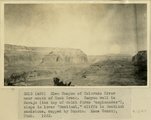
Glen Canyon of Colorado River near mouth of Rock Creek Canyon wall in Navajo, the top of which forms 'esplanades', slope in lower 'Sentinel,' cliffs in Sentinel sandstone, capped by Dakota. Kane County, UT. 1922
P0013 Herbert E. Gregory Photograph Collection
P0013n08_124_1549
103
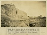
North bank of Glen Canyon of the Colorado, near Meskin Bar. Section includes Navajo to Dakota sandstone. Kane County, UT. 1922
P0013 Herbert E. Gregory Photograph Collection
P0013n08_124_1550
104
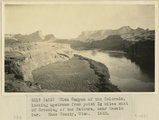
Glen Canyon of the Colorado, looking upstream from point 3 miles east of Crossing of the Fathers, near Meskin Bar. Kane County, UT. 1922
P0013 Herbert E. Gregory Photograph Collection
P0013n08_125_1551
105
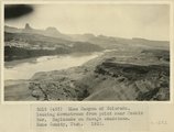
Glen Canyon of Colorado, looking downstream from point near Meskin Bar, Esplanade on Navajo sandstone. Kane County, UT. 1922
P0013 Herbert E. Gregory Photograph Collection
P0013n08_125_1552
106
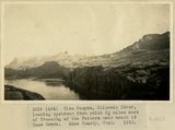
Glen Canyon, Colorado River, looking upstream from point 3 miles east of Crossing of the Fathers near mouth of Kane Creek. Kane County, UT. 1922
P0013 Herbert E. Gregory Photograph Collection
P0013n08_126_1553
107
Kane Springs Valley, east end of Gunsight Pass. Strata 'Sentinel' formation. Kane County, UT. 1922
P0013 Herbert E. Gregory Photograph Collection
P0013n08_126_1554
108
Kane Springs Valley, east end of Gunsight Pass. Strata 'Sentinel' formation. Kane County, UT. 1922
P0013 Herbert E. Gregory Photograph Collection
P0013n08_127_1555
109
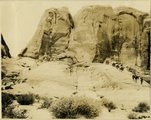
Gunsight Pass between Last Chance Greek and Kane Creek. Kaiparowitz Plateau. Strata upper part " Sentinel" formation. Kane County, Utah. 1922
P0013 Herbert E. Gregory Photograph Collection
P0013n08_127_1556
110
Gunsight Pass between Last Chance Greek and Kane Creek. Kaiparowitz Plateau. Strata upper part " Sentinel" formation. Kane County, Utah. 1922
P0013 Herbert E. Gregory Photograph Collection
P0013n08_127_1557
111
Gunsight Pass from Last Chance Valley to Kane Springs Valley. Strata massive sandstone of 'Sentinel'. Kane County, UT. 1922
P0013 Herbert E. Gregory Photograph Collection
P0013n08_128_1558
112
Scene in Last Chance Creek. Kaiparowitz Plateau. Upper sandstone beds of 'Sentinel' formation in distance. Kane County, UT. 1922
P0013 Herbert E. Gregory Photograph Collection
P0013n08_128_1559
113
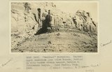
"Sentinel formation." Section B banded strata below heavy sandstone. Kaiparowitz region. Kane County, UT. 1922
P0013 Herbert E. Gregory Photograph Collection
P0013n08_129_1560
114
"Sentinel formation." Section B banded strata below heavy sandstone. Kaiparowitz region. Kane County, UT. 1922
P0013 Herbert E. Gregory Photograph Collection
P0013n08_129_1561
115
"Sentinel formation." Contact upper sandstone Section A with banded portion beneath, Section B. Cottonwood Canyon. Kane County, UT. 1922
P0013 Herbert E. Gregory Photograph Collection
P0013n08_130_1562
116
'"Sentinel formation." Contact upper sandstone just below Dakota, Section A, with banded strata beneath, Section B. Cottonwood Canyon. Kane County, UT. 1922
P0013 Herbert E. Gregory Photograph Collection
P0013n08_130_1563
117
Butte, composed of massive white rock below Dakota. Note horse and rider. Lower Wahweap Valley. Kane County, UT. 1922
P0013 Herbert E. Gregory Photograph Collection
P0013n08_131_1564
118
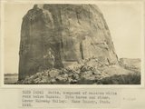
West side of lower Wahweap Valley. Valley walls of banded Sentinel formation, butte of massive white rock, upper part of Sentinel capped by Dakota. Kane County, UT. 1922
P0013 Herbert E. Gregory Photograph Collection
P0013n08_131_1565
119
East side of lower Wahweap Valley. White rocks below Dakota. Kane County, UT. 1922
P0013 Herbert E. Gregory Photograph Collection
P0013n08_132_1566
120
Wall of White Rock Gulch. (tributary to Wahweap) 'Sentinel' strata. Kane County, UT. 1922
P0013 Herbert E. Gregory Photograph Collection
P0013n08_132_1567
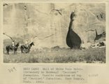
121
Wall of White Rock Gulch. (tributary to Wahweap) 'Sentinel' formation. Massive sandstone on top of 'Sentinel' formation. Kane County, UT. 1922
P0013 Herbert E. Gregory Photograph Collection
P0013n08_132_1568
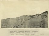
122
Moenkopi strata. Shabkaib member. Three miles southwest of Paria. Kane County, UT. 1922
P0013 Herbert E. Gregory Photograph Collection
P0013n08_133_1569
123
Moenkopi strata. Shabkaib member. Three miles southwest of Paria. Kane County, UT. 1922
P0013 Herbert E. Gregory Photograph Collection
P0013n08_133_1570
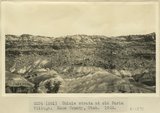
124
Chinle strata at old Paria Village. Kane County, UT. 1922
P0013 Herbert E. Gregory Photograph Collection
P0013n08_134_1571
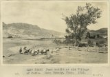
125
Pack outfit at old Village of Paria. Kane County, UT. 1922
P0013 Herbert E. Gregory Photograph Collection
P0013n08_134_1572
101
-
125
of
2,385
<
1
2
3
4
5
6
7
8
9
10
>