|
|
Title | Collection Number And Name | Photo Number |
| 26 |
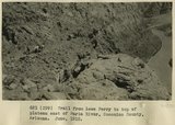 |
Trail from Lees Ferry to top of plateau east of Paria River, Coconino County, Arizona. June, 1915. | P0013 Herbert E. Gregory Photograph Collection | P0013n08_012_1330 |
| 27 |
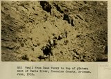 |
Trail from Lees Ferry to top of plateau east of Paria River, Coconino County, Arizona. June, 1915. | P0013 Herbert E. Gregory Photograph Collection | P0013n08_013_1331 |
| 28 |
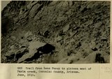 |
Trail from Lees Ferry to top of plateau east of Paria River, Coconino County, Arizona. June, 1915. | P0013 Herbert E. Gregory Photograph Collection | P0013n08_013_1332 |
| 29 |
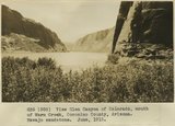 |
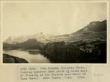
View Glen Canyon of Colorado, mouth of Warm Creek, Coconino County, Arizona. Navajo sandstone. June, 1915. | P0013 Herbert E. Gregory Photograph Collection | P0013n08_015_1335 |
| 30 |
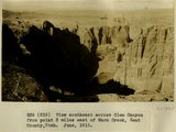 |
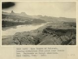
View southeast across Glen Canyon from point 3 miles east of Warm Creek, Kane County, Utah. June, 1915. | P0013 Herbert E. Gregory Photograph Collection | P0013n08_019_1345 |
| 31 |
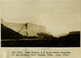 |
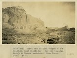
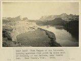
Glen Canyon, 4+ miles above Crossing of the Fathers, Kane County, Utah. June, 1915. | P0013 Herbert E. Gregory Photograph Collection | P0013n08_019_1346 |
| 32 |
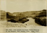 |
Glen Canyon, 4+ miles above Crossing of the Fathers, Kane County, Utah. June, 1915. | P0013 Herbert E. Gregory Photograph Collection | P0013n08_020_1347 |
| 33 |
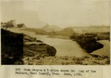 |
Glen Canyon, 4+ miles above Crossing of the Fathers, Kane County, Utah. June, 1915. | P0013 Herbert E. Gregory Photograph Collection | P0013n08_020_1348 |
| 34 |
 |
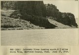
Colorado River at Hite, Utah, June 1915 | P0013 Herbert E. Gregory Photograph Collection | P0013n08_032_1371 |
| 35 |
 |
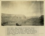
Colorado River looking south 3+ miles above Hite, Garfield County, Utah, June 19, 1915. | P0013 Herbert E. Gregory Photograph Collection | P0013n08_032_1372 |
| 36 |
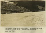 |
Crossing of Colorado River 3+ miles above Hite, Garfield County, Utah. Note horses swimming. June 19, 1915. | P0013 Herbert E. Gregory Photograph Collection | P0013n08_033_1373 |
| 37 |
 |
Glen Canyon of Colorado River near mouth of Rock Creek Canyon wall in Navajo, the top of which forms 'esplanades', slope in lower 'Sentinel,' cliffs in Sentinel sandstone, capped by Dakota. Kane County, UT. 1922 | P0013 Herbert E. Gregory Photograph Collection | P0013n08_124_1549 |
| 38 |
 |
North bank of Glen Canyon of the Colorado, near Meskin Bar. Section includes Navajo to Dakota sandstone. Kane County, UT. 1922 | P0013 Herbert E. Gregory Photograph Collection | P0013n08_124_1550 |
| 39 |
 |
Glen Canyon of the Colorado, looking upstream from point 3 miles east of Crossing of the Fathers, near Meskin Bar. Kane County, UT. 1922 | P0013 Herbert E. Gregory Photograph Collection | P0013n08_125_1551 |
| 40 |
 |
Glen Canyon of Colorado, looking downstream from point near Meskin Bar, Esplanade on Navajo sandstone. Kane County, UT. 1922 | P0013 Herbert E. Gregory Photograph Collection | P0013n08_125_1552 |
| 41 |
 |
Glen Canyon, Colorado River, looking upstream from point 3 miles east of Crossing of the Fathers near mouth of Kane Creek. Kane County, UT. 1922 | P0013 Herbert E. Gregory Photograph Collection | P0013n08_126_1553 |
| 42 |
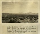 |
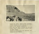
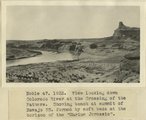
View up Colorado River from a point 3 miles east of Cottonwood Cove. Navajo Mountain in background. Terrace in foreground is at the horizon of the 'Marine Jurassic' | P0013 Herbert E. Gregory Photograph Collection | P0013n08_170_1665 |
| 43 |
 |
Bench along Colorado River formed by soft beds at the horizon of the 'Marine Jurassic'. The view was taken looking up Colorado River from a point about 2 miles west of Kane Creek. Cliffs in background are Sentinel(?) formation and McElmo | P0013 Herbert E. Gregory Photograph Collection | P0013n08_171_1669 |
| 44 |
 |
View looking down Colorado river at the Crossing of the Fathers. Showing bench at summit of Navajo SS. formed by soft beds at the horizon of the 'Marine Jurassic' | P0013 Herbert E. Gregory Photograph Collection | P0013n08_171_1671 |
| 45 |
 |
View up Colorado River from a point 3 miles below Meskin Bar, showing bench developed at the horizon of the 'Marine Jurassic'. Cliffs in background are Sentinel and McElmo formations. I measured a section of the beds at the horizon of the 'Marine Jurassic' at the farthest point up the river where the beds are visible in this view | P0013 Herbert E. Gregory Photograph Collection | P0013n08_171_1672 |
| 46 |
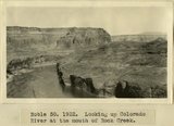 |
Looking up Colorado River at the mouth of Rock Creek | P0013 Herbert E. Gregory Photograph Collection | P0013n08_172_1674 |
| 47 |
 |
Colorado River looking up stream from the mouth of Moki Canyon. | P0013 Herbert E. Gregory Photograph Collection | P0013n10_003_2095 |
| 48 |
 |
Colorado River looking down stream from the mouth of Moki Canyon (at the left). | P0013 Herbert E. Gregory Photograph Collection | P0013n10_004_2096 |
| 49 |
 |
Looking up Colorado toward mouth of San Juan, 1921. | P0013 Herbert E. Gregory Photograph Collection | P0013n10_249_2527 |
| 50 |
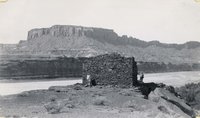 |
Ruins of Indian Fortress | P0022 Arthur Crawford Photograph Collection | P0022n12 |