|
|
Title | Collection Number And Name | Photo Number |
| 1 |
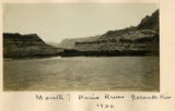 |
Mouth of Paria River, Colorado River, 1900 | P0013 Herbert E. Gregory Photograph Collection | P0013n01_39_104 |
| 2 |
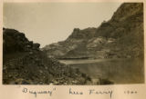 |
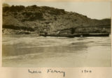
"Dugway," Lees Ferry 1900 | P0013 Herbert E. Gregory Photograph Collection | P0013n01_39_105 |
| 3 |
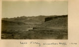 |
Lees Ferry, Vermillion Cliffs, 1900 | P0013 Herbert E. Gregory Photograph Collection | P0013n01_40_106 |
| 4 |
 |
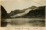
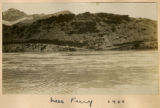
Lees Ferry, 1900 [1] | P0013 Herbert E. Gregory Photograph Collection | P0013n01_40_107 |
| 5 |
 |
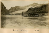
Lees Ferry, 1900 [2] | P0013 Herbert E. Gregory Photograph Collection | P0013n01_40_108 |
| 6 |
 |
Lees Ferry, 1900 [3] | P0013 Herbert E. Gregory Photograph Collection | P0013n01_40_109 |
| 7 |
 |
Lees Ferry, 1900 [4] | P0013 Herbert E. Gregory Photograph Collection | P0013n01_41_110 |
| 8 |
 |
Lees Ferry, 1900 [5] | P0013 Herbert E. Gregory Photograph Collection | P0013n01_41_111 |
| 9 |
 |
View looking N.40 degrees W. up Paria River, Arizona, from top of Shinarump, south side of Colorado at Lees Ferry, Coconino County, Arizona. June 5, 1915. | P0013 Herbert E. Gregory Photograph Collection | P0013n08_004_1313 |
| 10 |
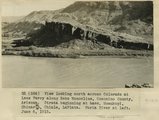 |
View looking north across Colorado at Lees Ferry along Echo Monocline, Coconino County, Arizona. Strata beginning at base: Moenkopi, Shinarump, Chinle, LaPlata. Paria River at left, June 6, 1915. | P0013 Herbert E. Gregory Photograph Collection | P0013n08_005_1314 |
| 11 |
 |
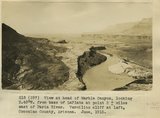
View looking S.50 degrees W, from south side Colorado at head of Marble Canyon, Coconino County. Vermilion cliffs in right background. June 6, 1915. | P0013 Herbert E. Gregory Photograph Collection | P0013n08_005_1315 |
| 12 |
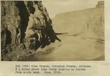 |
Glen Canyon, Coconino County, Arizona, 3+ miles above Lees Ferry looking up stream from south bank. June 1915. | P0013 Herbert E. Gregory Photograph Collection | P0013n08_008_1321 |
| 13 |
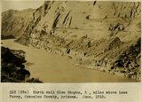 |
North wall Glen Canyon 2 miles above Lees Ferry, Coconino County, Arizona. June, 1915. | P0013 Herbert E. Gregory Photograph Collection | P0013n08_009_1322 |
| 14 |
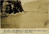 |
Glen Canyon, 3+ miles above Lees Ferry looking up stream from south bank. June, 1915. | P0013 Herbert E. Gregory Photograph Collection | P0013n08_009_1323 |
| 15 |
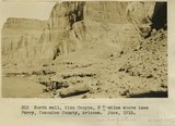 |
Glen Canyon, 3+ miles above Lees Ferry Coconino County, Arizona. June, 1915. | P0013 Herbert E. Gregory Photograph Collection | P0013n08_010_1324 |
| 16 |
 |
View at head of Marble Canyon, looking S.40 degrees W, from base of LaPlata at point 2+ miles east of Paria River. Vermilion cliff at left, Coconino County, Arizona. June, 1915. | P0013 Herbert E. Gregory Photograph Collection | P0013n08_011_1327 |
| 17 |
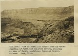 |
View of Vermilion cliffs looking across junction of Paria and Colorado rivers, standing at base of Navajo sandstone, Coconino County, Arizona. June, 1915. | P0013 Herbert E. Gregory Photograph Collection | P0013n08_011_1328 |
| 18 |
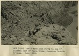 |
Trail from Lees Ferry to top of plateau east of Paria River, Coconino County, Arizona. June, 1915. | P0013 Herbert E. Gregory Photograph Collection | P0013n08_012_1330 |
| 19 |
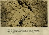 |
Trail from Lees Ferry to top of plateau east of Paria River, Coconino County, Arizona. June, 1915. | P0013 Herbert E. Gregory Photograph Collection | P0013n08_013_1331 |
| 20 |
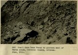 |
Trail from Lees Ferry to top of plateau east of Paria River, Coconino County, Arizona. June, 1915. | P0013 Herbert E. Gregory Photograph Collection | P0013n08_013_1332 |
| 21 |
 |
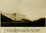
View Glen Canyon of Colorado, mouth of Warm Creek, Coconino County, Arizona. Navajo sandstone. June, 1915. | P0013 Herbert E. Gregory Photograph Collection | P0013n08_015_1335 |
| 22 |
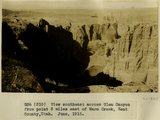 |
View southeast across Glen Canyon from point 3 miles east of Warm Creek, Kane County, Utah. June, 1915. | P0013 Herbert E. Gregory Photograph Collection | P0013n08_019_1345 |
| 23 |
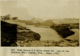
 |
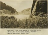
Glen Canyon, 4+ miles above Crossing of the Fathers, Kane County, Utah. June, 1915. | P0013 Herbert E. Gregory Photograph Collection | P0013n08_019_1346 |
| 24 |
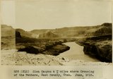 |
Glen Canyon, 4+ miles above Crossing of the Fathers, Kane County, Utah. June, 1915. | P0013 Herbert E. Gregory Photograph Collection | P0013n08_020_1347 |
| 25 |
 |
Glen Canyon, 4+ miles above Crossing of the Fathers, Kane County, Utah. June, 1915. | P0013 Herbert E. Gregory Photograph Collection | P0013n08_020_1348 |