Home
Browse
Ask Us
Chat
Harmful Language Statement
Log in
Advanced Search
Year
1937
1938
1939
1940
1941
1942
1943
1944
1945
1946
1947
1948
1949
1950
1951
1952
1953
1954
1955
1956
1957
1958
1959
1960
1961
1962
1963
1964
1965
1966
1967
1968
1969
1970
1971
1972
1973
1974
1975
1976
1977
1978
1979
1980
1981
1982
1983
1984
1985
1986
1987
1988
1989
1990
1991
1992
1993
1994
1995
1996
1997
1998
1999
2000
2001
2002
2003
2004
2005
2006
2007
2008
2009
TO
1937
1938
1939
1940
1941
1942
1943
1944
1945
1946
1947
1948
1949
1950
1951
1952
1953
1954
1955
1956
1957
1958
1959
1960
1961
1962
1963
1964
1965
1966
1967
1968
1969
1970
1971
1972
1973
1974
1975
1976
1977
1978
1979
1980
1981
1982
1983
1984
1985
1986
1987
1988
1989
1990
1991
1992
1993
1994
1995
1996
1997
1998
1999
2000
2001
2002
2003
2004
2005
2006
2007
2008
2009
Type
Image
9
Image/MovingImage
1
Sound
1
Text
1
Format
image/jpeg
9
application/pdf
1
video/mp4
1
Collection
Audio-Visual Archives Collections
1
Photo Archives
9
Utah Historical Society Oral History ...
1
Filters:
Subject:
"Capitol Reef National Park (Utah)"
1
-
25
of
11
Gallery view
Number of results to display per page
10
25
50
100
200
Sort by Relevance
Sort by Title A-Z
Sort by Title Z-A
Sort by Date Ascending
Sort by Date Descending
Sort by Last Modified Ascending
Sort by Last Modified Descending
Title
Date
Type
Setname
1
Capitol Reef
1950; 1951; 1952; 1953; 1954; 1955; 1956; 1957; 1958; 1959; 1960
Image/MovingImage
uum_avac
2
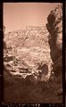
Chinle and Wingate, Fremont River near Fruita, Wayne County, Utah, 1937.
1937
Image
uum_map
3
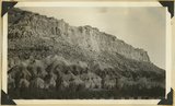
Freemont Canyon
1937
Image
uum_map
4
Freemont Canyon just above Fruita, 1937.
1937
Image
uum_map
5
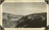
Fremont River Canyon
1937
Image
uum_map
6
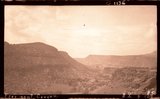
Fremont River canyon west of Fruita (Moenkopi strata), Wayne County, Utah, 1937.
1937
Image
uum_map
7
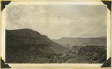
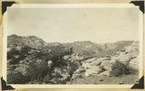
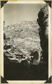
Looking up Fremont River canyon west of Fruita, Miners Mesa in middle distance, Wayne County, Utah, 1937.
1937
Image
uum_map
8
National (Natural) Bridge, Bridge Canyon 3 miles northeast of Fruita, Wayne County, Utah, 1937.
1937
Image
uum_map
9
Oral history interview with Katherine Heyder by Dan Rhode
2009-10-16
Text; Sound
dha_uhsoh
10
Same as 809 (Natural Bridge, Bridge Canyon 3 miles northeast of Fruita, Wayne County, Utah), 1937.
1937
Image
uum_map
11
Wall (Moenkopi) of upper Fremont River canyon at deepest part west of Fruita, Utah, 1937.
1937
Image
uum_map
1
-
25
of
11