Home
Browse
Ask Us
Chat
Harmful Language Statement
Log in
Advanced Search
Year
1872
1873
1874
1875
1876
1877
1878
1879
1880
1881
1882
1883
1884
1885
1886
1887
1888
1889
1890
1891
1892
1893
1894
1895
1896
1897
1898
1899
1900
1901
1902
1903
1904
1905
1906
1907
1908
1909
1910
1911
1912
1913
1914
1915
1916
1917
1918
1919
1920
1921
1922
1923
1924
1925
1926
1927
1928
1929
1930
1931
1932
1933
1934
1935
1936
1937
1938
1939
1940
1941
1942
1943
1944
1945
1946
1947
1948
1949
1950
1951
1952
1953
1954
1955
1956
1957
1958
1959
1960
1961
1962
1963
1964
1965
1966
1967
1968
1969
1970
1971
1972
1973
1974
1975
1976
1977
1978
1979
1980
1981
1982
1983
1984
1985
1986
1987
1988
1989
1990
1991
1992
1993
1994
1995
1996
1997
1998
1999
2000
2001
2002
2003
2004
2005
2006
2007
2008
2009
2010
TO
1872
1873
1874
1875
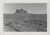
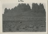
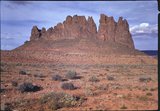
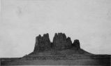
1876
1877
1878
1879
1880
1881
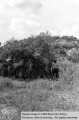
1882
1883
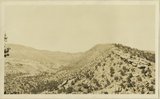
1884
1885
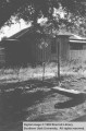
1886
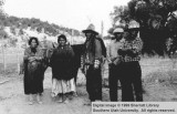
1887
1888
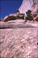
1889
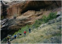
1890
1891
1892
1893
1894
1895
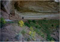
1896
1897
1898
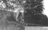
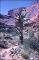
1899
1900
1901
1902
1903
1904
1905
1906
1907
1908
1909
1910
1911
1912
1913
1914
1915
1916
1917
1918
1919
1920
1921
1922
1923
1924
1925
1926
1927
1928
1929
1930
1931
1932
1933
1934
1935
1936
1937
1938
1939
1940
1941
1942
1943
1944
1945
1946
1947
1948
1949
1950
1951
1952
1953
1954
1955
1956
1957
1958
1959
1960
1961
1962
1963
1964
1965
1966
1967
1968
1969
1970
1971
1972
1973
1974
1975
1976
1977
1978
1979
1980
1981
1982
1983
1984
1985
1986
1987
1988
1989
1990
1991
1992
1993
1994
1995
1996
1997
1998
1999
2000
2001
2002
2003
2004
2005
2006
2007
2008
2009
2010
Type
Image/StillImage
2,013
Image
1,948
Text
286
Image/MovingImage
5
Sound
1
Format
image/jpeg
3,829
application/pdf
727
video/mp4
5
audio/mpeg
1
Collection
Beckwith Photograph Collection
2
Home Movie Collection
5
Photo Archives
1,412
Ski and Snow Sports Archives
43
UAIDA Main Collection
948
Utah Humanities Research Foundation
25
Utah Quilt Heritage Records
2
Utah River Running Photo Archives
2,129
Western Soundscape
1
Western Waters NEH
1
More
Filters:
Spatial Coverage:
"San Juan County (Utah)"
151
-
175
of
4,568
<
2
3
4
5
6
7
8
9
10
11
>
Gallery view
Number of results to display per page
10
25
50
100
200
Sort by Relevance
Sort by Title A-Z
Sort by Title Z-A
Sort by Date Ascending
Sort by Date Descending
Sort by Last Modified Ascending
Sort by Last Modified Descending
Title
Date
Type
Setname
151
Alhambra
1925; 1926; 1927; 1928; 1929; 1930; 1931; 1932; 1933; 1934; 1935; 1936; 1937; 1938; 1939; 1940; 1941; 1942; 1943; 1944; 1945; 1946; 1947; 1948; 1949
Image
uum_map_rr
152
Alhambra dike south of Goodridge, Utah. (EGW)
1909
Image
uum_map
153
Alhambra Rock
1929
Image
uum_map_rr
154
Alhambra Rock
1925; 1926; 1927; 1928; 1929; 1930; 1931; 1932; 1933; 1934; 1935; 1936; 1937; 1938; 1939; 1940; 1941; 1942; 1943; 1944; 1945; 1946; 1947; 1948; 1949
Image
uum_map_rr
155
Alhambra Rock
1940; 1941; 1942; 1943; 1944; 1945; 1946; 1947; 1948; 1949
Image/StillImage
uum_map_rr
156
Alhambra Rock near Mexican Hat, Utah [1]
Image
uum_map
157
Alhambra Rock near Mexican Hat, Utah [2]
Image
uum_map
158
Allen Canyon brush home; San Juan County, Utah [I]
Image/StillImage
uaida_main
159
Allen Canyon brush home; San Juan County, Utah [II]
Image/StillImage
uaida_main
160
Allen Canyon country outer slope of Comb monocline. San Juan County, UT, 1925. Wall of ridge includes Moenkopi and Chinle, head of Whiskers Creek
1925
Image
uum_map
161
Allen Canyon country outer slope of Comb monocline. San Juan County, UT, 1925. Wall of ridge includes Moenkopi and Chinle, head of Whiskers Creek
1925
Image
uum_map
162
Allen Canyon Indian Agency and agent Black's home; Allen Canyon, San Juan County, Utah
1935
Image/StillImage
uaida_main
163
Allen Canyon Paiutes; San Juan County, Utah
1935-08-23
Image/StillImage
uaida_main
164
Alluvial fill exposed by recent erosion. Comb Wash, San Juan County, Utah, 1929.
1929
Image
uum_map
165
Almost to the top of Rope climb
1957; 1958; 1959; 1960; 1961; 1962
uum_map_rr
166
Ancestral Puebloan ruins, October 1997 [07]
1997-10
Image/StillImage
uum_map_rr
167
Ancestral Puebloan ruins, October 1997 [11]
1997-10
Image/StillImage
uum_map_rr
168
Ancestral Puebloan ruins, October 1997 [12]
1997-10
Image/StillImage
uum_map_rr
169
Ancestral Puebloan ruins, October 1997 [18]
1997-10
Image/StillImage
uum_map_rr
170
Ancestral Puebloan ruins, October 1997 [21]
1997-10
Image/StillImage
uum_map_rr
171
Ancestral Puebloan ruins, October 1997 [24]
1997-10
Image/StillImage
uum_map_rr
172
Ancient granary, Davis Canyon, Canyonlands, May 1970
1970-05
Image/StillImage
uum_map_rr
173
Ancient granary, Davis Canyon, Canyonlands, May 1970
1970-05
Image/StillImage
uum_map_rr
174
Ancient ladder some rungs recently nailed on leading to Cliff ruins 2 miles above Augusta Bridge, White Canyon
1928
Image
uum_map
175
Ancient tree along Trail to Bridge
1957; 1958; 1959; 1960; 1961; 1962
uum_map_rr
151
-
175
of
4,568
<
2
3
4
5
6
7
8
9
10
11
>