| Title | Date | Type | Setname | ||
|---|---|---|---|---|---|
| 1 |
 |
Bitter Creek, NE-18, (US DOI BLM) 1975 (revised) | 1975 | Image/StillImage | ucl_maps |
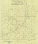
| 2 |
 |
Bonanza - Rainbow Area Mine | 1973; 1980 | Image/StillImage | ucl_maps |
| 3 |
 |
Critical Habitat Polygons for Penstemon Grahamii | Image/StillImage | ucl_maps | |
| 4 |
 |
Engineering Cross Section on the Rainbow & Pride-of-the-West Gilsonite Vein | 1978 | Image/StillImage | ucl_maps |
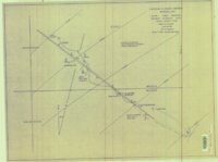
| 5 |
 |
Map Showing Geologic Structure of Rainbow - Bonanza - Black Dragon Areas, Uintah County, Utah | 1978 | Image/StillImage | ucl_maps |
| 6 |
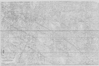 |
Rainbow Area Topographic Map Showing Gilsonite Veins, Leases & Claims - Ziegler Chemical & Mineral Corp | 1979; 1996 | Image/StillImage | ucl_maps |
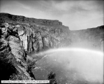
| 7 |
 |
Shoshone Falls and Rainbow | 1912-06-05 | Image | dha_scp |
| 8 |
 |
Shoshone Falls, Below Falls with Rainbow | 1912-06-05 | Image | dha_scp |
| 9 |
 |
Uintah Railway Elevation Map 1930 | 1930 | Image/StillImage | ucl_maps |
| 10 |
 |
Ziegler Chemical Inventory Unit Mining Claims - May 21, 1999 | 1999 | Image/StillImage | ucl_maps |