|
|
Title | Collection Number And Name | Photo Number |
| 126 |
 |
Contact Jurassic and consolidated valley fill (Pleistocene?) in gulch east of Mt. Carmel Junction. Kane County, Utah, 1932. | P0013 Herbert E. Gregory Photograph Collection | P0013n10_118_2287 |
| 127 |
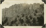 |
Straight Cliffs, sandstone Cretaceous above Tropic shale. Orderville, Kane County, Utah, 1932. | P0013 Herbert E. Gregory Photograph Collection | P0013n10_118_2288 |
| 128 |
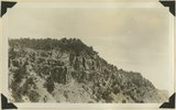 |
Straight Cliffs, sandstone north of Orderville, Kane County, Utah, 1932. | P0013 Herbert E. Gregory Photograph Collection | P0013n10_119_2289 |
| 129 |
 |
Straight Cliffs, sandstone north of Orderville, Kane County, Utah, 1932. | P0013 Herbert E. Gregory Photograph Collection | P0013n10_119_2289 |
| 130 |
 |
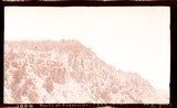
Tropic shale Muddy Brook Valley west of Orderville, Kane County, Utah, 1932. | P0013 Herbert E. Gregory Photograph Collection | P0013n10_119_2290 |
| 131 |
 |
Elkheart Cliffs along highway about mile north of Orderville. Background and right foreground Navajo sandstone capped by Carmel formation. Left foreground slice of cliff dropped down along Sevier fault. Kane County, Utah, 1932. | P0013 Herbert E. Gregory Photograph Collection | P0013n10_120_2291 |
| 132 |
 |
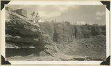
Exposure of weathered bsalt in flow from isolated cone near "corrals," upper Kanab Valley. Pinon and juniper. Kane County, Utah, 1932. | P0013 Herbert E. Gregory Photograph Collection | P0013n10_120_2292 |
| 133 |
 |
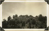
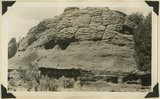
Basalt cone near "corrals," upper Kanab Valley. Pinon and juniper. Kane County, Utah, 1932. | P0013 Herbert E. Gregory Photograph Collection | P0013n10_121_2293 |
| 134 |
 |
Carmel limestone at falls of upper Kanab Valley. Kane County, Utah, 1932. | P0013 Herbert E. Gregory Photograph Collection | P0013n10_121_2294 |
| 135 |
 |
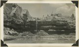
View at falls, upper Kanab Valley near "Corrals." At left, Carmel limestone over which present stream falls; right valley fill in former valley. Kane County, Utah, 1932. | P0013 Herbert E. Gregory Photograph Collection | P0013n10_122_2295 |
| 136 |
 |
Carmel limestone wall at Kanab Canyon. Kane County, Utah, 1932. | P0013 Herbert E. Gregory Photograph Collection | P0013n10_122_2296 |
| 137 |
 |
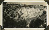
Cretaceous (above Tropic shale) capped by Wasatch of Paunsaugunt Plateau near head of Deer Springs Canyon. Kane County, Utah, 1934. | P0013 Herbert E. Gregory Photograph Collection | P0013n10_123_2297 |
| 138 |
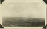 |
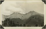
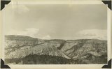
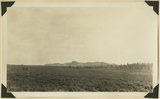
View looking west from Black Knoll across valley, tributary to Johnson Creek, Black Knob Volcano in left middle distance, topography typical of Cretaceous and topmost Jurassic beds of Skutumpah Terrace. Kane County, Utah, 1934. | P0013 Herbert E. Gregory Photograph Collection | P0013n10_124_2298 |
| 139 |
 |
Topmost Jurassic with thin cap of Dakota 3± miles northwest of Findley Ranch. Kane County, Utah, 1934. | P0013 Herbert E. Gregory Photograph Collection | P0013n10_125_2299 |
| 140 |
 |
Head of Kitchen Canyon. Right, looking east along fault. Navajo sandstone of White Cliffs; left, Carmel formation. Kane County, Utah, 1934. | P0013 Herbert E. Gregory Photograph Collection | P0013n10_125_2300 |
| 141 |
 |
Foot of lake in Swallow Park, entrance to "Corral Canyon." Navajo sandstone. Kane County, Utah, 1934. | P0013 Herbert E. Gregory Photograph Collection | P0013n10_126_2301 |
| 142 |
 |
Beveled erosion surface above alluvium flat into which is cut Deer Range wash. Kane County, Utah, 1934. | P0013 Herbert E. Gregory Photograph Collection | P0013n10_127_2302 |
| 143 |
 |
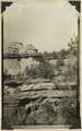
Wingate sandstone, upper Kaibab Gulch. Kane County, Utah, 1934. | P0013 Herbert E. Gregory Photograph Collection | P0013n10_128_2303 |
| 144 |
 |
Wingate sandstone, upper Kaibab Gulch. Kane County, Utah, 1934. | P0013 Herbert E. Gregory Photograph Collection | P0013n10_128_2304 |
| 145 |
 |
Wingate sandstone, upper Kaibab Gulch. Kane County, Utah, 1934. | P0013 Herbert E. Gregory Photograph Collection | P0013n10_128_2304 |
| 146 |
 |
Wingate sandstone on an unusual form of Chinle. Branch of Johnson Canyon. Kane County, Utah, 1934. | P0013 Herbert E. Gregory Photograph Collection | P0013n10_129_2305 |
| 147 |
 |
Surface of Paunsaugunt Plateau developed in Wasatch limestone, near head of Red Canyon looking west to highlands along Sevier fault. Garfield County, Utah, 1934. | P0013 Herbert E. Gregory Photograph Collection | P0013n10_129_2306 |
| 148 |
 |
Paunsaugunt Plateau developed in Wasatch limestone, near head of Red Canyon looking north toward volcanic mesas. Garfield County, Utah, 1934. | P0013 Herbert E. Gregory Photograph Collection | P0013n10_130_2307 |
| 149 |
 |
Jurassic beds above Navajo sandstone, Harris Mountain northeast of Cane Springs. Fossiliferous Carmel middle distance. Kane County, Utah, 1934. | P0013 Herbert E. Gregory Photograph Collection | P0013n10_131_2309 |
| 150 |
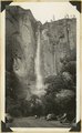 |
Water fall in Temple of Sinawava, Zion National Park, Utah, 1934. | P0013 Herbert E. Gregory Photograph Collection | P0013n10_200_2448 |