Over 70,000 photos covering a variety of topics from Marriott Library Special Collections
TO
| Title | Collection Number And Name | Photo Number | ||
|---|---|---|---|---|
| 76 |
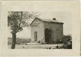 |
John H. Rice bank building, Silver Reef, Utah ca. 1928 | P0008 Mark A. Pendleton Photograph Collection | P0008n01_05_055 |
| 77 |
 |
Tooele, Utah | P0008 Mark A. Pendleton Photograph Collection | P0008n01_08_070 |
| 78 |
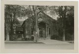 |
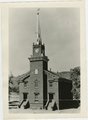
Tooele Ward chapel | P0008 Mark A. Pendleton Photograph Collection | P0008n01_08_071 |
| 79 |
 |
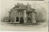
Toeele County Court House | P0008 Mark A. Pendleton Photograph Collection | P0008n01_08_072 |
| 80 |
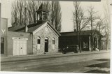 |
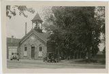
Tooele County court house and fire station | P0008 Mark A. Pendleton Photograph Collection | P0008n01_08_073 |
| 81 |
 |
St. George tabernacle ca 1929 | P0008 Mark A. Pendleton Photograph Collection | P0008n01_09_078 |
| 82 |
 |
St. George, Utah, Tabernacle center right | P0008 Mark A. Pendleton Photograph Collection | P0008n01_09_079 |
| 83 |
 |
Gin house at Toquerville | P0008 Mark A. Pendleton Photograph Collection | P0008n01_09_084 |
| 84 |
 |
Ensign Peak monument | P0008 Mark A. Pendleton Photograph Collection | P0008n01_09_085 |
| 85 |
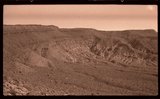 |
Barren landscape, Washington County: Panorama, part one | P0008 Mark A. Pendleton Photograph Collection | P0008n01_10_087 |
| 86 |
 |
Barren landscape, Washington County: Panorama, part two | P0008 Mark A. Pendleton Photograph Collection | P0008n01_10_088 |
| 87 |
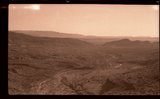 |
Barren landscape, Washington County: Panorama, part three | P0008 Mark A. Pendleton Photograph Collection | P0008n01_10_089 |
| 88 |
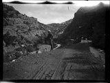 |
Little Creek Canyon road | P0008 Mark A. Pendleton Photograph Collection | P0008n01_10_090 |
| 89 |
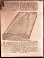 |
Generalized diagram showing relations of the formations near Silver Reef | P0008 Mark A. Pendleton Photograph Collection | P0008n01_10_094 |
| 90 |
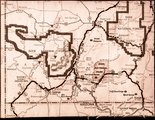 |
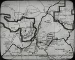
Map of southwestern Utah | P0008 Mark A. Pendleton Photograph Collection | P0008n01_10_095 |
| 91 |
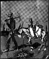 |
Illustration of a miner and his pack mule | P0008 Mark A. Pendleton Photograph Collection | P0008n01_10_096 |
| 92 |
 |
Map of southwestern Utah | P0008 Mark A. Pendleton Photograph Collection | P0008n01_11_097 |
| 93 |
 |
Silver Reef, circa 1928 | P0008 Mark A. Pendleton Photograph Collection | P0008n01_11_099 |
| 94 |
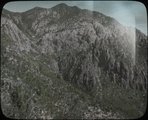 |
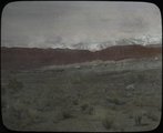
Pine Valley Mountains | P0008 Mark A. Pendleton Photograph Collection | P0008n01_11_100 |
| 95 |
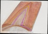 |
Generalized diagram showing relations of the formations near Silver Reef | P0008 Mark A. Pendleton Photograph Collection | P0008n01_11_101 |
| 96 |
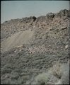 |
One of the mine dumps at Silver Reef, circa 1928 | P0008 Mark A. Pendleton Photograph Collection | P0008n01_11_102 |
| 97 |
 |
Barbee and Walker mine and Mill site on west side of reef, circa 1928 | P0008 Mark A. Pendleton Photograph Collection | P0008n01_11_103 |
| 98 |
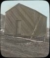 |
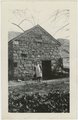
Old Silver Reef jail trasported to Sterlings field in Leeds, used as an ice house | P0008 Mark A. Pendleton Photograph Collection | P0008n01_11_116 |
| 99 |
 |
Wells Fargo Building, Silver Reef, circa 1928 | P0008 Mark A. Pendleton Photograph Collection | P0008n01_11_123 |
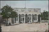
| 100 |
 |
John H. Rice Bank Building, Silver Reef, circa 1928. | P0008 Mark A. Pendleton Photograph Collection | P0008n01_11_124 |