Home
Browse
Ask Us
Chat
Harmful Language Statement
Log in
Photo Archives
Advanced Search
About
Over 70,000 photos covering a variety of topics from Marriott Library Special Collections
Year
1845
1846
1847
1848
1849
1850
1851
1852
1853
1854
1855
1856
1857
1858
1859
1860
1861
1862
1863
1864
1865
1866
1867
1868
1869
1870
1871
1872
1873
1874
1875
1876
1877
1878
1879
1880
1881
1882
1883
1884
1885
1886
1887
1888
1889
1890
1891
1892
1893
1894
1895
1896
1897
1898
1899
1900
1901
1902
1903
1904
1905
1906
1907
1908
1909
1910
1911
1912
1913
1914
1915
1916
1917
1918
1919
1920
1921
1922
1923
1924
1925
1926
1927
1928
1929
1930
1931
1932
1933
1934
1935
1936
1937
1938
1939
1940
1941
1942
1943
1944
1945
1946
1947
1948
1949
1950
1951
1952
1953
1954
1955
1956
1957
1958
1959
1960
1961
1962
1963
1964
1965
1966
1967
1968
1969
1970
1971
1972
1973
1974
1975
1976
1977
1978
1979
1980
TO
1845
1846
1847
1848
1849
1850
1851
1852
1853
1854
1855
1856
1857
1858
1859
1860
1861
1862
1863
1864
1865
1866
1867
1868
1869
1870
1871
1872
1873
1874
1875
1876
1877
1878
1879
1880
1881
1882
1883
1884
1885
1886
1887
1888
1889
1890
1891
1892
1893
1894
1895
1896
1897
1898
1899
1900
1901
1902
1903
1904
1905
1906
1907
1908
1909
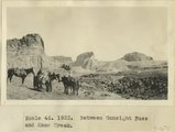
1910
1911
1912
1913
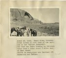
1914
1915
1916
1917
1918
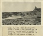
1919
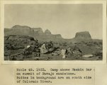
1920
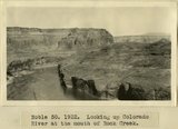
1921
1922
1923
1924
1925
1926
1927
1928
1929
1930
1931
1932
1933
1934
1935
1936
1937
1938
1939
1940
1941
1942
1943
1944
1945
1946
1947
1948
1949
1950
1951
1952
1953
1954
1955
1956
1957
1958
1959
1960
1961
1962
1963
1964
1965
1966
1967
1968
1969
1970
1971
1972
1973
1974
1975
1976
1977
1978
1979
1980
Type
Image
2,437
Format
image/jpeg
2,385
application/pdf
52
Collection Name
Shipler Studio
734
Emigration Canyon History
273
Newell Beeman
191
Herbert E. Gregory
174
Alta Club
156
Charles Neal
143
Albion W. and Agnes Sharp Caine
92
George D. Pyper
87
Mining Photograph Collection
83
Greek Archives
80
Fort Douglas
59
Everett Ruess Family
44
Edward P. Jennings
40
Rocky Mountain Power Company
33
Olive Woolley Burt
31
Charles Kelly
28
Seamount Family
24
Waldo Wilcox
18
Henry Y. Kasai
16
Milford and Alda F. Gardner
12
Hope A. Hilton
11
Japanese Church of Christ
10
Italian
9
Rosezella Dalton Hardy
9
Preston Nutter Corporation
7
Bingham Stage Lines
6
Orvil LaVell Sadler
6
Southern Slavic
6
Stephanie Young Merzel
6
Vyrie Gray
6
Lyman P. Hunter
4
Philip T. Blair
4
Provo, Utah
4
Melba Goff Matthews
3
Ole Pettit
3
Wasatch Mountain Club
3
William Caine Patrick
3
Agnes Just Reid
2
Barbara J. Hamblin
2
Clifford Evans
2
The Great Salt Lake
2
Angus Woodbury
1
Colorado
1
Edward Hunter Family
1
Geraldine Palmer Jones
1
Helper, Utah
1
Hiram B. Clawson
1
Kunio Yamada digital photograph collection
1
LDS Church History
1
Leo Leonard
1
U of U Presidents
1
Wallace Stegner
1
More
Filters:
Date:
"1922"
Collection:
"uum_map"
Type:
"Image"
201
-
225
of
2,437
<
4
5
6
7
8
9
10
11
12
13
>
Gallery view
Number of results to display per page
10
25
50
100
200
Sort by Relevance
Sort by Title A-Z
Sort by Title Z-A
Sort by Date Ascending
Sort by Date Descending
Sort by Last Modified Ascending
Sort by Last Modified Descending
Sort by Photo Number
Title
Collection Number And Name
Photo Number
201
White cliffs of Navajo Sandstone on upper Kanab Creek, capped, in the background, by limestone of the 'Marine Jurassic.' 1922
P0013 Herbert E. Gregory Photograph Collection
P0013n08_165_1648
202
Contact between Navajo sandstone and Marine Jurassic on upper Kanab Creek. 1922
P0013 Herbert E. Gregory Photograph Collection
P0013n08_166_1649
203
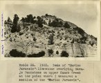
Beds of 'Marine Jurassic' limestone overlying Navajo Sandstone on upper Kanab Creek at the point where Dr. Gregory measured a section of the 'Marine Jurassic' in 1922.
P0013 Herbert E. Gregory Photograph Collection
P0013n08_166_1650
204
Quaking asps, Paunsaugunt Plateau. 1922
P0013 Herbert E. Gregory Photograph Collection
P0013n08_166_1651
205
Cliffs of Tertiary limestone under rim of Paunsaugunt Plateau at a point about 7 miles NE of Alton, Kane County, Utah, in 1922.
P0013 Herbert E. Gregory Photograph Collection
P0013n08_166_1652
206
Bryce Canyon, 1922
P0013 Herbert E. Gregory Photograph Collection
P0013n08_167_1653
207
Camp in canyon of Paria Creek in white Navajo sandstone. Dorthy and Dinah Watts
P0013 Herbert E. Gregory Photograph Collection
P0013n08_168_1657
208
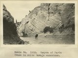
Canyon of Paria Creek in white Navajo sandstone
P0013 Herbert E. Gregory Photograph Collection
P0013n08_168_1658
209
Entering Paria
P0013 Herbert E. Gregory Photograph Collection
P0013n08_168_1659
210
Entering Paria
P0013 Herbert E. Gregory Photograph Collection
P0013n08_168_1660
211
Base of Kaibab limestone and summit of Hermit Shale in Kaibab (Buckskin) Gulch. Coconino sandstone absent
P0013 Herbert E. Gregory Photograph Collection
P0013n08_169_1661
212
Contact between Kaibab and Moenkopi in Kaibab (Buckskin) Gulch
P0013 Herbert E. Gregory Photograph Collection
P0013n08_169_1662
213
Lone Rock, Wahweap Creek
P0013 Herbert E. Gregory Photograph Collection
P0013n08_169_1663
214
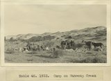
Camp on Wahweap Creek
P0013 Herbert E. Gregory Photograph Collection
P0013n08_169_1664
215
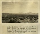
View up Colorado River from a point 3 miles east of Cottonwood Cove. Navajo Mountain in background. Terrace in foreground is at the horizon of the 'Marine Jurassic'
P0013 Herbert E. Gregory Photograph Collection
P0013n08_170_1665
216
Panoramic with view attached
P0013 Herbert E. Gregory Photograph Collection
P0013n08_170_1666
217
Gunsight Pass looking east from Gunsight Cove
P0013 Herbert E. Gregory Photograph Collection
P0013n08_170_1667
218
Gunsight Pass
P0013 Herbert E. Gregory Photograph Collection
P0013n08_170_1668
219
Bench along Colorado River formed by soft beds at the horizon of the 'Marine Jurassic'. The view was taken looking up Colorado River from a point about 2 miles west of Kane Creek. Cliffs in background are Sentinel(?) formation and McElmo
P0013 Herbert E. Gregory Photograph Collection
P0013n08_171_1669
220
Between Gunsight Pass and Kane Creek
P0013 Herbert E. Gregory Photograph Collection
P0013n08_171_1670
221
View looking down Colorado river at the Crossing of the Fathers. Showing bench at summit of Navajo SS. formed by soft beds at the horizon of the 'Marine Jurassic'
P0013 Herbert E. Gregory Photograph Collection
P0013n08_171_1671
222
View up Colorado River from a point 3 miles below Meskin Bar, showing bench developed at the horizon of the 'Marine Jurassic'. Cliffs in background are Sentinel and McElmo formations. I measured a section of the beds at the horizon of the 'Marine Jurassic' at the farthest point up the river where the beds are visible in this view
P0013 Herbert E. Gregory Photograph Collection
P0013n08_171_1672
223
Camp above Meskin Bar on summit of navajo sandstone. Buttes in background are on south side of Colorado
P0013 Herbert E. Gregory Photograph Collection
P0013n08_172_1673
224
Looking up Colorado River at the mouth of Rock Creek
P0013 Herbert E. Gregory Photograph Collection
P0013n08_172_1674
225
Camp on rim of Kaiparowitz Plateau
P0013 Herbert E. Gregory Photograph Collection
P0013n08_172_1675
201
-
225
of
2,437
<
4
5
6
7
8
9
10
11
12
13
>