|
|
Title | Collection Number And Name | Photo Number |
| 176 |
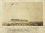 |
Mesa near Pipe Springs, UT. Moenkopi strata with Shinarump cap. Washington County, UT. 1922 | P0013 Herbert E. Gregory Photograph Collection | P0013n08_157_1622 |
| 177 |
 |
Mesa extending from High Plateau. Moenkopi with Shinarump cap near Pipe Springs, UT. Washington County, UT. 1922 | P0013 Herbert E. Gregory Photograph Collection | P0013n08_158_1623 |
| 178 |
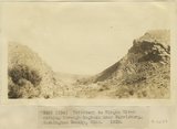 |
Tributary to Virgin River cutting through hogback near Harrisburg, Washington County, UT. 1922 | P0013 Herbert E. Gregory Photograph Collection | P0013n08_158_1624 |
| 179 |
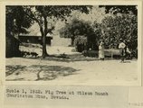 |
Fig Tree at Wilson Ranch, Charleston Mountains, NV. 1922 | P0013 Herbert E. Gregory Photograph Collection | P0013n08_159_1625 |
| 180 |
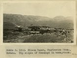 |
Wilson Ranch, Charleston Mountains, NV. Dip slopes of Moenkopi in background. 1922 | P0013 Herbert E. Gregory Photograph Collection | P0013n08_159_1626 |
| 181 |
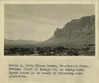 |
Wilson Ranch, Charleston Mountains, NV. Cliff of Navajo SS. in background. Ranch house is on bench of Shinarump conglomerate. 1922 | P0013 Herbert E. Gregory Photograph Collection | P0013n08_159_1627 |
| 182 |
 |
Froehmer House at Littlefield. 1922 | P0013 Herbert E. Gregory Photograph Collection | P0013n08_159_1628 |
| 183 |
 |
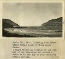
Looking up canyon of lower Kanab Creek from a point 3 miles below the mouth of Snake Gulch. AZ. 1922 | P0013 Herbert E. Gregory Photograph Collection | P0013n08_161_1637 |
| 184 |
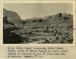 |
Supai Sandstone, lower Kanab Creek. Mouth of Karks Canyon at left. Arrow points to horizon of bed of limestone conglomerate. AZ | P0013 Herbert E. Gregory Photograph Collection | P0013n08_161_1638 |
| 185 |
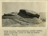 |
Cross-bedding, summit member, Supai sandstone, mouth of Jump Up Canyon, AZ. 1922 | P0013 Herbert E. Gregory Photograph Collection | P0013n08_161_1639 |
| 186 |
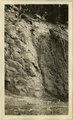 |
[Faulting in rock layers, probably Kanab Creek Canyon, Arizona, 1922] | P0013 Herbert E. Gregory Photograph Collection | P0013n08_161_1640 |
| 187 |
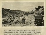 |
'Marine Jurassic' beds, Paunuweap, 4 miles below Mt. Carmel., at point where we measured section. UT | P0013 Herbert E. Gregory Photograph Collection | P0013n08_162_1641 |
| 188 |
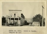 |
Hotel at Kanab. Gregory by car | P0013 Herbert E. Gregory Photograph Collection | P0013n08_162_1642 |
| 189 |
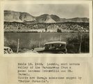 |
Looking east across valley of the Parunuweap from a point between Orderville and Mt. Carmel. Cliffs are Navajo sandstone capped by 'Marine Jurassic' | P0013 Herbert E. Gregory Photograph Collection | P0013n08_162_1643 |
| 190 |
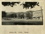 |
Kanab, Utah | P0013 Herbert E. Gregory Photograph Collection | P0013n08_162_1644 |
| 191 |
 |
Church at St. George, NV. 1922 | P0013 Herbert E. Gregory Photograph Collection | P0013n08_163_1629 |
| 192 |
 |
Repairing washed out road in Zion Canyon, UT. 1922 | P0013 Herbert E. Gregory Photograph Collection | P0013n08_163_1630 |
| 193 |
 |
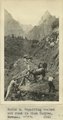
Town of Hurricane from Hurricane Cliff. Pine Valley Mountains in background. UT. 1922 | P0013 Herbert E. Gregory Photograph Collection | P0013n08_163_1631 |
| 194 |
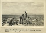 |
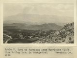
First camp out of Fredonia, UT. 1922 | P0013 Herbert E. Gregory Photograph Collection | P0013n08_163_1632 |
| 195 |
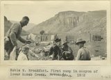 |
Breakfast. First camp in canyon of lower Kanab Creek, AZ. 1922 | P0013 Herbert E. Gregory Photograph Collection | P0013n08_164_1633 |
| 196 |
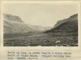 |
Camp in Kanab Canyon 2 miles below mouth of Snake Gulch. Gregory rolling bed. AZ. 1922 | P0013 Herbert E. Gregory Photograph Collection | P0013n08_164_1634 |
| 197 |
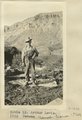 |
Arthur Lewis. Kanab Camp, UT. 1922 | P0013 Herbert E. Gregory Photograph Collection | P0013n08_164_1636 |
| 198 |
 |
Kanab. Showing Tithing House, Hotel, and church. 1922 | P0013 Herbert E. Gregory Photograph Collection | P0013n08_165_1645 |
| 199 |
 |
Looking down Kanab Creek from a point 3 miles above Kanab. I began measuring section at the summit of the sandstone bed marked x, which is at the top of your measured Chinle section. 1922 | P0013 Herbert E. Gregory Photograph Collection | P0013n08_165_1646 |
| 200 |
 |
Looking down Kanab Creek from a point 3 miles above Kanab. I began measuring section at the summit of the sandstone bed marked x, which is at the top of your measured Chinle section. 1922 | P0013 Herbert E. Gregory Photograph Collection | P0013n08_165_1647 |