Over 70,000 photos covering a variety of topics from Marriott Library Special Collections
TO
| Title | Collection Number And Name | Photo Number | ||
|---|---|---|---|---|
| 226 |
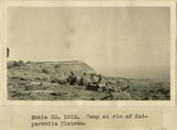 |
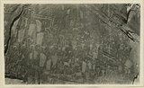
Camp on rim of Kaiparowitz Plateau | P0013 Herbert E. Gregory Photograph Collection | P0013n08_172_1676 |
| 227 |
 |
Navajo Mountain from end of Kaiparowitz Plateau | P0013 Herbert E. Gregory Photograph Collection | P0013n08_173_1677 |
| 228 |
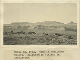 |
Camp in Escalante Desert. Kaiparowitz Plateau in background | P0013 Herbert E. Gregory Photograph Collection | P0013n08_173_1679 |
| 229 |
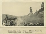 |
Camp at Liston Ranch between Escalante and Henrieville | P0013 Herbert E. Gregory Photograph Collection | P0013n08_173_1680 |
| 230 |
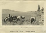 |
Liston Ranch | P0013 Herbert E. Gregory Photograph Collection | P0013n08_174_1681 |
| 231 |
 |
Liston Ranch, Marion | P0013 Herbert E. Gregory Photograph Collection | P0013n08_174_1682 |
| 232 |
 |
Liston Ranch, Dewey | P0013 Herbert E. Gregory Photograph Collection | P0013n08_174_1683 |
| 233 |
 |
Liston Ranch, Sam | P0013 Herbert E. Gregory Photograph Collection | P0013n08_174_1684 |
| 234 |
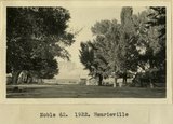 |
Henrieville | P0013 Herbert E. Gregory Photograph Collection | P0013n08_175_1685 |
| 235 |
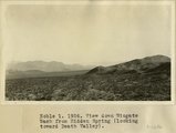 |
View down Wingate Wash from Hidden Spring, looking toward Death Valley | P0013 Herbert E. Gregory Photograph Collection | P0013n08_176_1686 |
| 236 |
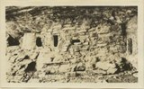 |
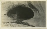
Cliff House, Fable Valley (Fred Lowrey, Honolulu) | P0013 Herbert E. Gregory Photograph Collection | P0013n09_145_1996 |
| 237 |
 |
Cliff House, Fable Valley (Fred Lowrey, Honolulu) | P0013 Herbert E. Gregory Photograph Collection | P0013n09_145_1997 |
| 238 |
 |
Cliff House, Fable Valley (Fred Lowrey, Honolulu) | P0013 Herbert E. Gregory Photograph Collection | P0013n09_145_1998 |
| 239 |
 |
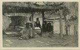
Survey headquarters, Blanding, UT. Lowrey | P0013 Herbert E. Gregory Photograph Collection | P0013n09_145_1999 |
| 240 |
 |
San Juan River between narrows and mouth of Chinle, U. S. G. S., Miser, 418 | P0013 Herbert E. Gregory Photograph Collection | P0013n09_151_2007 |
| 241 |
 |
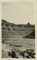
San Juan Canyon between Honoker trail and Johns Canyon, Goodridge formation, Miser | P0013 Herbert E. Gregory Photograph Collection | P0013n09_152_2008 |
| 242 |
 |
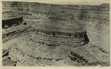
San Juan Canyon at mouth of Grand Gulch. Goodridge, Moonlight, and Hermit formations, Miser | P0013 Herbert E. Gregory Photograph Collection | P0013n09_152_2009 |
| 243 |
 |
Red House in Red Canyon, U. S. G. S., Miser, 448 | P0013 Herbert E. Gregory Photograph Collection | P0013n09_153_2010 |
| 244 |
 |
Sand Flat Skewer Camp, San Juan River | P0013 Herbert E. Gregory Photograph Collection | P0013n09_153_2011 |
| 245 |
 |
Abandoned Logan, San Juan River, 10 miles above mouth | P0013 Herbert E. Gregory Photograph Collection | P0013n09_154_2012 |
| 246 |
 |
Inscriptions right bank, Glen Canyon below Smith's Fork | P0013 Herbert E. Gregory Photograph Collection | P0013n09_154_2013 |
| 247 |
 |
Cliff house north side of San Juan near Bluff | P0013 Herbert E. Gregory Photograph Collection | P0013n09_155_2014 |
| 248 |
 |
Jim Joe's House, U.S.G.S. = U.S. Geological Survey, Miser 654 (Robert T. Allen), near mouth of Butler Wash | P0013 Herbert E. Gregory Photograph Collection | P0013n09_155_2015 |
| 249 |
 |
Tabernacle loop, San Juan River | P0013 Herbert E. Gregory Photograph Collection | P0013n09_156_2016 |
| 250 |
 |
Looking down San Juan River, 3/4 mile below Makai Creek | P0013 Herbert E. Gregory Photograph Collection | P0013n09_156_2017 |