Home
Browse
Ask Us
Chat
Harmful Language Statement
Log in
Photo Archives
Advanced Search
About
Over 70,000 photos covering a variety of topics from Marriott Library Special Collections
Year
1845
1846
1847
1848
1849
1850
1851
1852
1853
1854
1855
1856
1857
1858
1859
1860
1861
1862
1863
1864
1865
1866
1867
1868
1869
1870
1871
1872
1873
1874
1875
1876
1877
1878
1879
1880
1881
1882
1883
1884
1885
1886
1887
1888
1889
1890
1891
1892
1893
1894
1895
1896
1897
1898
1899
1900
1901
1902
1903
1904
1905
1906
1907
1908
1909
1910
1911
1912
1913
1914
1915
1916
1917
1918
1919
1920
1921
1922
1923
1924
1925
1926
1927
1928
1929
1930
1931
1932
1933
1934
1935
1936
1937
1938
1939
1940
1941
1942
1943
1944
1945
1946
1947
1948
1949
1950
1951
1952
1953
1954
1955
1956
1957
1958
1959
1960
1961
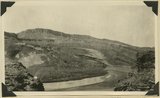
1962
1963
1964
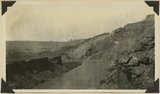
1965
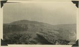
1966
1967
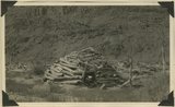
1968
1969
1970
1971
1972
1973
1974
1975
1976
1977
1978
1979
1980
TO
1845
1846
1847
1848
1849
1850
1851
1852
1853
1854
1855
1856
1857
1858
1859
1860
1861
1862
1863
1864
1865
1866
1867
1868
1869
1870
1871
1872
1873
1874
1875
1876
1877
1878
1879
1880
1881
1882
1883
1884
1885
1886
1887
1888
1889
1890
1891
1892
1893
1894
1895
1896
1897
1898
1899
1900
1901
1902
1903
1904
1905
1906
1907
1908
1909
1910
1911
1912
1913
1914
1915
1916
1917
1918
1919
1920
1921
1922
1923
1924
1925
1926
1927
1928
1929
1930
1931
1932
1933
1934
1935
1936
1937
1938
1939
1940
1941
1942
1943
1944
1945
1946
1947
1948
1949
1950
1951
1952
1953
1954
1955
1956
1957
1958
1959
1960
1961
1962
1963
1964
1965
1966
1967
1968
1969
1970
1971
1972
1973
1974
1975
1976
1977
1978
1979
1980
Type
Image
2,334
Format
image/jpeg
2,282
application/pdf
52
Collection Name
Shipler Studio
733
Emigration Canyon History
273
Newell Beeman
191
Alta Club
157
Charles Neal
143
Albion W. and Agnes Sharp Caine
92
George D. Pyper
87
Mining Photograph Collection
83
Greek Archives
80
Herbert E. Gregory
68
Fort Douglas
58
Everett Ruess Family
45
Edward P. Jennings
40
Rocky Mountain Power Company
31
Olive Woolley Burt
30
Charles Kelly
28
Seamount Family
24
Waldo Wilcox
18
Henry Y. Kasai
16
Hope A. Hilton
16
Milford and Alda F. Gardner
11
Rosezella Dalton Hardy
10
Italian
9
Preston Nutter Corporation
9
Japanese Church of Christ
7
Bingham Stage Lines
6
Orvil LaVell Sadler
6
Stephanie Young Merzel
6
Vyrie Gray
6
Lyman P. Hunter
5
Southern Slavic
5
Philip T. Blair
4
Provo, Utah
4
Melba Goff Matthews
3
Ole Pettit
3
Wasatch Mountain Club
3
William Caine Patrick
3
Agnes Just Reid
2
Barbara J. Hamblin
2
Clifford Evans
2
The Great Salt Lake
2
U of U Presidents
2
Angus Woodbury
1
Colorado
1
Duchesne, Utah
1
Edward Hunter Family
1
Geraldine Palmer Jones
1
Helper, Utah
1
Hiram B. Clawson
1
Kunio Yamada digital photograph collection
1
LDS Church History
1
Leo Leonard
1
Wallace Stegner
1
More
Filters:
Date:
"1921"
Collection:
"uum_map"
Type:
"Image"
126
-
150
of
2,334
<
1
2
3
4
5
6
7
8
9
10
>
Gallery view
Number of results to display per page
10
25
50
100
200
Sort by Relevance
Sort by Title A-Z
Sort by Title Z-A
Sort by Date Ascending
Sort by Date Descending
Sort by Last Modified Ascending
Sort by Last Modified Descending
Sort by Photo Number
Title
Collection Number And Name
Photo Number
126
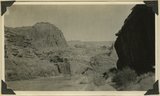
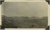
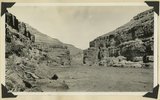
Entrance into San Juan Canyon just below mouth of Chinle Creek. Canyon in Goodridge formation. Looking southwest. 1921. San Juan County, UT
P0013 Herbert E. Gregory Photograph Collection
P0013n09_194_2074
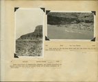
127
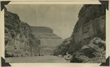
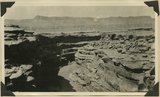
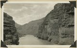
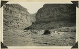
The Narrows in San Juan Canyon. Goodridge formation in canyon walls. San Juan County, UT
P0013 Herbert E. Gregory Photograph Collection
P0013n09_194_2075
128
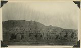
Looking northwest from head of Honaker Trail. Cedar Mesa in distance capped by Moonlight sandstone. Hermit shale in lower part of escarpment of Cedar Mesa. Goodridge formation underlies plateau in foreground and right distance. San Juan County, UT. 1921
P0013 Herbert E. Gregory Photograph Collection
P0013n09_194_2076
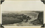
129
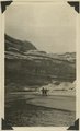
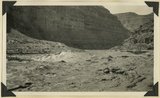
Camp in San Juan Canyon near mouth of Johns Canyon. Lower Part of wall formed by Goodridge formation and upper part by Moonlight sandstone and Hermit shale. San Juan County, UT. 1921
P0013 Herbert E. Gregory Photograph Collection
P0013n09_195_2077
130
Looking west from Clay Hill Crossing on the San Juan. Rock formations are Todilto, Wingate, Chinle and Moenkopi. San Juan County, UT, 1921
P0013 Herbert E. Gregory Photograph Collection
P0013n09_195_2078
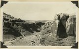
131
Looking down San Juan Canyon between mouth of Moonlight Creek and Clay Hill Crossing. Canyon walls formed by Moonlight sandstone. Note sand waves in shadow. San Juan County, UT. 1921
P0013 Herbert E. Gregory Photograph Collection
P0013n09_195_2079
132
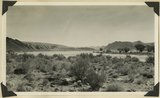
San Juan Canyon some 8 miles below Spencer camp. Canyon walls formed by Navajo, Todilto, and Wingate formations which dip at low angle to west. San Juan County, 1921
P0013 Herbert E. Gregory Photograph Collection
P0013n09_196_2080
133
Looking down San Juan Canyon between mouth of Moonlight Creek and Clay Hill Crossing. Canyon walls formed by Moonlight sandstone. K.W. Trimble topographic engineer, at plane table. R.W. Allen recorder, standing nearby. San Juan County, UT. H. D. Miser, 1921
P0013 Herbert E. Gregory Photograph Collection
P0013n09_196_2081
134
Abandoned hogan on east side of the San Juan some 3 miles above the mouth of Pinte Creek. San Juan County, UT. 1921
P0013 Herbert E. Gregory Photograph Collection
P0013n09_196_2082
135
Looking southwest down the San Juan from a point about one mile above the mouth of Nokai Creek. Cliffs in foreground are composed entirely of Shinarump conglomerate. Inclined beds in right distance are Shinarump (on point of mesa) and Moenkopi with the De Chelly sandstone lentil. San Juan County, UT. 1921
P0013 Herbert E. Gregory Photograph Collection
P0013n09_197_2083
136
Looking north up San Juan from top of cliff near mouth of Nokai Creek. Shinarump forms cliff in foreground. Formation in distance are Moenkopi (with De Chelly sandstone lentil), Shinarump, Chinle, Wingate and Todilto. 1921. San Juan County, UT
P0013 Herbert E. Gregory Photograph Collection
P0013n09_197_2084
137
Panorama. Looking north and northeast from point about 2 miles south of San Juan. Nokai Creek to right. Shinarump conglomerate caps Monoclinal ridges in foreground. San Juan County, UT. 1921
P0013 Herbert E. Gregory Photograph Collection
P0013n09_198_2085
138
Panorama. Looking north and northeast from point about 2 miles south of San Juan. Nokai Creek to right. Shinarump conglomerate caps Monoclinal ridges in foreground. San Juan County, UT. 1921
P0013 Herbert E. Gregory Photograph Collection
P0013n09_198_2086
139
Herbert E. Gregory Book 10: San Juan, Zion, Capitol Reef, 1915-1938
P0013 Herbert E. Gregory Photograph Collection
P0013n10
140
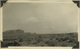
Looking southwest across Bluff Utah, Comb Ridge in distance, 1921.
P0013 Herbert E. Gregory Photograph Collection
P0013n10_237_2507
141
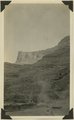
Looking up Cow Canyon near Bluff, Utah, "Bluff sandstone" forms cap rock, 1921.
P0013 Herbert E. Gregory Photograph Collection
P0013n10_238_2508
142
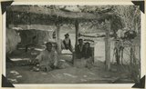
Jim Joe's house and family near mouth of Butler Wash, 1921.
P0013 Herbert E. Gregory Photograph Collection
P0013n10_239_2509
143
Looking up Comb Wash from mouth of Chinle, 1921.
P0013 Herbert E. Gregory Photograph Collection
P0013n10_240_2510
144
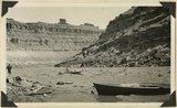
Rapids in San Juan Canyon 4 miles below Comb Wash. Bert Loper in boat, 1921.
P0013 Herbert E. Gregory Photograph Collection
P0013n10_240_2511
145
Looking down San Juan River in "Narrows" through Raplee anticline, 1921.
P0013 Herbert E. Gregory Photograph Collection
P0013n10_241_2512
146
Looking up stream in "Narrows" in Raplee anticline, San Juan Canyon, 1921.
P0013 Herbert E. Gregory Photograph Collection
P0013n10_241_2513
147
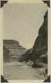
Looking down San Juan through the "Narrows," 1921.
P0013 Herbert E. Gregory Photograph Collection
P0013n10_242_2514
148
"Sand waves" just breaking and flattening near Honoker Trail, San Juan canyon, 1921.
P0013 Herbert E. Gregory Photograph Collection
P0013n10_243_2515
149
Sand waves just breaking near Honoker Trail, San Juan canyon, 1921.
P0013 Herbert E. Gregory Photograph Collection
P0013n10_243_2516
150
Tabernacle Loop: goosenecks beyond San Juan canyon, 1921.
P0013 Herbert E. Gregory Photograph Collection
P0013n10_244_2517
126
-
150
of
2,334
<
1
2
3
4
5
6
7
8
9
10
>