Home
Browse
Ask Us
Chat
Harmful Language Statement
Log in
Photo Archives
Advanced Search
About
Over 70,000 photos covering a variety of topics from Marriott Library Special Collections
Year
1875
1876
1877
1878
1879
1880
1881
1882
1883
1884
1885
1886
1887
1888
1889
1890
1891
1892
1893
1894
1895
1896
1897
1898
1899
1900
1901
1902
1903
1904
1905
1906
1907
1908
1909
1910
1911
1912
1913
1914
1915
1916
1917
1918
1919
1920
1921
1922
1923
1924
1925
1926
1927
1928
1929
1930
1931
1932
1933
1934
1935
1936
1937
1938
TO
1875
1876
1877
1878
1879
1880
1881
1882
1883
1884
1885
1886
1887
1888
1889
1890
1891
1892
1893
1894
1895
1896
1897
1898
1899
1900
1901
1902
1903
1904
1905
1906
1907
1908
1909
1910
1911
1912
1913
1914
1915
1916
1917
1918
1919
1920
1921
1922
1923
1924
1925
1926
1927
1928
1929
1930
1931
1932
1933
1934
1935
1936
1937
1938
Type
Image
68
Format
image/jpeg
66
application/pdf
2
Collection
Photo Archives
68
Filters:
Collection Name:
"Herbert E. Gregory"
Date:
"1921"
Type:
"Image"
1
-
25
of
68
<
1
2
3
>
Gallery view
Number of results to display per page
10
25
50
100
200
Sort by Relevance
Sort by Title A-Z
Sort by Title Z-A
Sort by Date Ascending
Sort by Date Descending
Sort by Last Modified Ascending
Sort by Last Modified Descending
Title
Date
Type
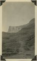
1
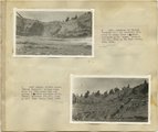
"Dome formation" (Navajo sandstone) east of "Wilson Creek," 1921.
1921
Image
2
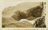
"Sand waves" just breaking and flattening near Honoker Trail, San Juan canyon, 1921.
1921
Image
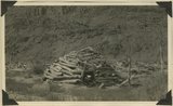
3
Abandoned hogan on east side of the San Juan some 3 miles above the mouth of Pinte Creek. San Juan County, UT. 1921
1921
Image
4
Abandoned Logan, San Juan River, 10 miles above mouth
1920; 1921; 1922; 1923; 1924; 1925; 1926; 1927; 1928; 1929; 1930
Image
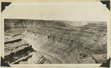
5
Arch Canyon, Coconino over Supai
1920; 1921; 1922; 1923; 1924; 1925; 1926; 1927; 1928; 1929; 1930
Image
6
Bluffs at Bluff, UT
1920; 1921; 1922; 1923; 1924; 1925; 1926; 1927; 1928; 1929; 1930
Image
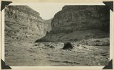
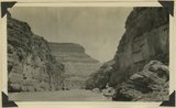
7
Camp in San Juan Canyon near mouth of Johns Canyon. Lower Part of wall formed by Goodridge formation and upper part by Moonlight sandstone and Hermit shale. San Juan County, UT. 1921
1921
Image
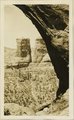
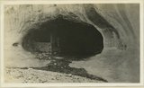
8
Cathedral Arch I. Arch Canyon
1920; 1921; 1922; 1923; 1924; 1925; 1926; 1927; 1928; 1929; 1930
Image
9
Cathedral Arch I. Arch Canyon
1920; 1921; 1922; 1923; 1924; 1925; 1926; 1927; 1928; 1929; 1930
Image
10
Cathedral Arch II, Arch Canyon, Coconino over Supai
1920; 1921; 1922; 1923; 1924; 1925; 1926; 1927; 1928; 1929; 1930
Image
11
Cathedral Arch II, Arch Canyon, Coconino over Supai
1920; 1921; 1922; 1923; 1924; 1925; 1926; 1927; 1928; 1929; 1930
Image
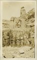
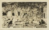
12
Cliff house north side of San Juan near Bluff
1920; 1921; 1922; 1923; 1924; 1925; 1926; 1927; 1928; 1929; 1930
Image
13
Cliff House, Fable Valley (Fred Lowrey, Honolulu)
1920; 1921; 1922; 1923; 1924; 1925; 1926; 1927; 1928; 1929; 1930
Image
14
Cliff House, Fable Valley (Fred Lowrey, Honolulu)
1920; 1921; 1922; 1923; 1924; 1925; 1926; 1927; 1928; 1929; 1930
Image
15
Cliff House, Fable Valley (Fred Lowrey, Honolulu)
1920; 1921; 1922; 1923; 1924; 1925; 1926; 1927; 1928; 1929; 1930
Image
16
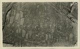
Entrance into San Juan Canyon just below mouth of Chinle Creek. Canyon in Goodridge formation. Looking southwest. 1921. San Juan County, UT
1921
Image
17
Entrance into San Juan Canyon just below mouth of Chinle Creek. Canyon in Goodridge formation. Looking southwest. 1921. San Juan County, UT
1921
Image
18
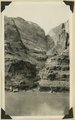
Goosenecks near Tabernacle Loop, San Juan canyon, 1921.
1921
Image
19
Herbert E. Gregory Book 10: San Juan, Zion, Capitol Reef, 1915-1938
1915; 1916; 1917; 1918; 1919; 1920; 1921; 1922; 1923; 1924; 1925; 1926; 1927; 1928; 1929; 1930; 1931; 1932; 1933; 1934; 1935; 1936; 1937; 1938
Image
20
Herbert E. Gregory Book 9: Utah, California, 1924-1928
1875; 1907; 1921; 1924; 1925; 1927; 1928
Image
21
Hole in the Rock, Colorado River, 10 miles above mouth of San Juan, 1921.
1921
Image
22
Inscriptions right bank, Glen Canyon below Smith's Fork
1920; 1921; 1922; 1923; 1924; 1925; 1926; 1927; 1928; 1929; 1930
Image
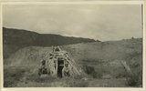
23
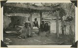
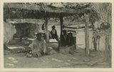
Jim Joe's house and family near mouth of Butler Wash, 1921.
1921
Image
24
Jim Joe's House, U.S.G.S. = U.S. Geological Survey, Miser 654 (Robert T. Allen), near mouth of Butler Wash
1920; 1921; 1922; 1923; 1924; 1925; 1926; 1927; 1928; 1929; 1930
Image
25
Keystone Arch, Arch Canyon, Coconino sandstone
1920; 1921; 1922; 1923; 1924; 1925; 1926; 1927; 1928; 1929; 1930
Image
1
-
25
of
68
<
1
2
3
>