Home
Browse
Ask Us
Chat
Harmful Language Statement
Log in
Advanced Search
Year
1860
1861
1862
1863
1864
1865
1866
1867
1868
1869
1870
1871
1872
1873
1874
1875
1876
1877
1878
1879
1880
1881
1882
1883
1884
1885
1886
1887
1888
1889
1890
1891
1892
1893
1894
1895
1896
1897
1898
1899
1900
1901
1902
1903
1904
1905
1906
1907
1908
1909
1910
1911
1912
1913
1914
1915
1916
1917
1918
1919
1920
1921
1922
1923
1924
1925
1926
1927
1928
1929
1930
1931
1932
1933
1934
1935
1936
1937
1938
1939
1940
1941
1942
1943
1944
1945
1946
1947
1948
1949
1950
1951
1952
1953
1954
1955
1956
1957
1958
1959
1960
1961
1962
1963
1964
1965
1966
1967
1968
1969
1970
1971
1972
1973
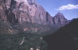
1974
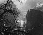
1975
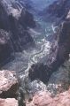
1976
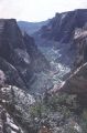
1977
1978
1979
1980
TO
1860
1861
1862
1863
1864
1865
1866
1867
1868
1869
1870
1871
1872
1873
1874
1875
1876
1877
1878
1879
1880
1881
1882
1883
1884
1885
1886
1887
1888
1889
1890
1891
1892
1893
1894
1895
1896
1897
1898
1899
1900
1901
1902
1903
1904
1905
1906
1907
1908
1909
1910
1911
1912
1913
1914
1915
1916
1917
1918
1919
1920
1921
1922
1923
1924
1925
1926
1927
1928
1929
1930
1931
1932
1933
1934
1935
1936
1937
1938
1939
1940
1941
1942
1943
1944
1945
1946
1947
1948
1949
1950
1951
1952
1953
1954
1955
1956
1957
1958
1959
1960
1961
1962
1963
1964
1965
1966
1967
1968
1969
1970
1971
1972
1973
1974
1975
1976
1977
1978
1979
1980
Type
Image
293
Format
image/jpeg
293
Collection
Beckwith Photograph Collection
9
Photo Archives
183
Utah River Running Photo Archives
101
Filters:
Format:
"image/jpeg"
Spatial Coverage:
"Zion National Park (Utah)"
Type:
"Image"
101
-
125
of
293
<
1
2
3
4
5
6
7
8
9
10
>
Gallery view
Number of results to display per page
10
25
50
100
200
Sort by Relevance
Sort by Title A-Z
Sort by Title Z-A
Sort by Date Ascending
Sort by Date Descending
Sort by Last Modified Ascending
Sort by Last Modified Descending
Title
Date
Type
Setname
101
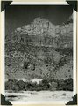
Upper Chinle, Wingate, Kayenta, and Navajo formations on face of Bridge Mountain. Springdale member, ledge near base. Zion National Park, UT
1937
Image
uum_map
102
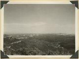
View from Great Arch Trail, Zion
1959-06-25
Image
uum_map
103
View in Zion Canyon, UT. LaPlata strata overlying Chinle. Kane County, UT. 1922
1922
Image
uum_map
104
View looking down Virgin River from Hornet Point, towers of Zion National Park in distance. Washington County, UT, 1940
1940
Image
uum_map
105
View looking north from Pace Knoll (lava) near Deadman Gulch, showing tilted strata east of Hurricane Cliffs (extreme left). Virgin member of Moenkopi, Shinarump conglomerate and Chinle sandstones make hogbacks. Horse Ranch knoll, Navajo and Carmel in upper right, Washington County, UT, 1941
1941
Image
uum_map
106
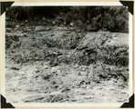
Virgin River in Zion National Park: erosion of land slide at flood stage
1937; 1938
Image
uum_map
107
Virgin River in Zion National Park: flood stage
1937; 1938
Image
uum_map
108
Virgin River in Zion National Park: flood stage
1937; 1938
Image
uum_map
109
Virgin River in Zion National Park: rising flood from shower on Kolob Terrace
1937; 1938
Image
uum_map
110
Virgin River in Zion National Park: rising flood from shower on Kolob Terrace
1937; 1938
Image
uum_map
111
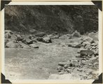
Virgin River Zion Park.
1861; 1862; 1863; 1864; 1865; 1866; 1867; 1868; 1869; 1870
Image
uum_map
112
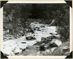
Virgin River, Zion Park.
1861; 1862; 1863; 1864; 1865; 1866; 1867; 1868; 1869; 1870
Image
uum_map
113
Walters Wiggles, in Refrigerator Canyon, on trail to Angels Landing. Navajo strata. Zion National Park, Utah, 1936.
1936
Image
uum_map
114
The Watchman at the mouth of Zion Canyon.
1930; 1931; 1932; 1933; 1934; 1935; 1936; 1937
Image
uum_map
115
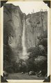
Water fall in Temple of Sinawava, Zion National Park, Utah, 1934.
1934
Image
uum_map
116
Waterfall from hanging valley during rain storm. Temple of Sinawava, Zion Canyon.
1930; 1931; 1932; 1933; 1934; 1935; 1936; 1937
Image
uum_map
117
Waterfalls during a storm in Zion Canyon
1970-11-26
Image
uum_map
118
Waterfalls during a storm in Zion Canyon
1970-11-26
Image
uum_map
119
West Temple, Zion National Park
1959-06-25
Image
uum_map
120
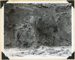
Wind and water erosion in sandstone. In Zion Canyon on west side of the Virgin River, about one-half mile above checking station.
1930; 1931; 1932; 1933; 1934; 1935; 1936; 1937
Image
uum_map
121
Winsor formation, two miles northeast of Horseranch Point, Zion National Monument. Iron County, UT, 1940
1940
Image
uum_map
122
Zion Canyon from near junction of Emerald Pool and Angels Landing trails
1959-06-24
Image
uum_map
123
Zion Canyon viewpoint
Image
uum_map
124
Zion Canyon, Zion National Park [1]
1937; 1938; 1939; 1940; 1941; 1942; 1943; 1944; 1945; 1946; 1947; 1948; 1949; 1950; 1951; 1952; 1953; 1954; 1955; 1956; 1957; 1958; 1959; 1960; 1961; 1962; 1963; 1964; 1965; 1966; 1967; 1968; 1969; 1970
Image
uum_map_rr
125
Zion Canyon, Zion National Park [2]
1937; 1938; 1939; 1940; 1941; 1942; 1943; 1944; 1945; 1946; 1947; 1948; 1949; 1950; 1951; 1952; 1953; 1954; 1955; 1956; 1957; 1958; 1959; 1960; 1961; 1962; 1963; 1964; 1965; 1966; 1967; 1968; 1969; 1970
Image
uum_map_rr
101
-
125
of
293
<
1
2
3
4
5
6
7
8
9
10
>