Over 70,000 photos covering a variety of topics from Marriott Library Special Collections
TO
| Title | Collection Number And Name | Photo Number | ||
|---|---|---|---|---|
| 1 |
 |
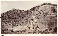
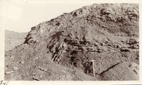
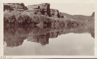
Bluff on the Moab road about 43 miles north of Monticello, Utah, showing LaPlata sandstone and McElmo formation. The upper La plata is about 200 feet thick and the lower La plata, the top of which is seen here, is about 300 feet, these sandstones are separated by red, shaly crinkled material. Lee, 1925. | P0013 Herbert E. Gregory Photograph Collection | P0013n09_179_2057 |
| 2 |
 |
Tower Butte and natural bridge in the Devils Garden, Entrada sandstone, south flank of the Salt Valley anticline, 15± miles west of Moab, Grand County, Utah, 1934. | P0013 Herbert E. Gregory Photograph Collection | P0013n10_216_2478 |
| 3 |
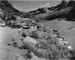 |
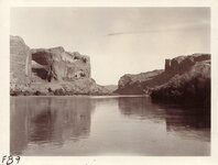
Boaters on the Colorado River near Moab | P0062 Utah Recreation Photograph Collection | P0062n01_01_03 |
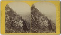
| 4 |
 |
Mountain Range near Castle Valley, Utah | P0066 Western and Mormon stereograph collection | P0066n01_03_015 |
| 5 |
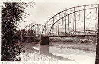
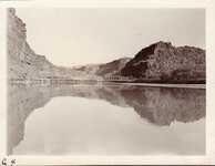
 |
Utah Series no. 19: Mt. range, Castle Valley in distance | P0066 Western and Mormon stereograph collection | P0066n01_09_007 |
| 6 |
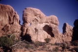 |
Arches National Park: Parade of Elephants | P0100 Charles Kelly Photograph Collection | P0100n1_16_08 |
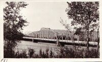
| 7 |
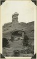
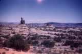 |
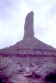
Arches National Park: Hoodoo | P0100 Charles Kelly Photograph Collection | P0100n1_16_10 |
| 8 |
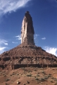 |
Castle Rock, Castle Valley, Utah [3] | P0100 Charles Kelly Photograph Collection | P0100n1_21_11 |
| 9 |
 |
Castle Rock, Castle Valley, Utah [1] | P0100 Charles Kelly Photograph Collection | P0100n1_37_24 |
| 10 |
 |
Castle Rock, Castle Valley, Utah [2] | P0100 Charles Kelly Photograph Collection | P0100n1_37_25 |
| 11 |
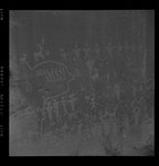 |
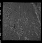
Petroglyphs, September, 1948 | P0244 Olive Woolley Burt Photograph Collection | P0244add2n2_0614 |
| 12 |
 |
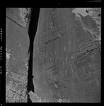
Petroglyphs near Moab on Colorado River [01] | P0244 Olive Woolley Burt Photograph Collection | P0244add2n2_0615 |
| 13 |
 |
Petroglyphs near Moab on Colorado River [02] | P0244 Olive Woolley Burt Photograph Collection | P0244add2n2_0616 |
| 14 |
 |
Petroglyphs near Moab on Colorado River [03] | P0244 Olive Woolley Burt Photograph Collection | P0244add2n2_0617 |
| 15 |
 |
Natural Bridges expedition, 1921: Hogbacks near Valley City, Utah | P0268 Frederick J. Pack photograph collection | P0268n01_12_002 |
| 16 |
 |
Natural Bridges expedition, 1921: Scenery north of Moab | P0268 Frederick J. Pack photograph collection | P0268n01_12_007 |
| 17 |
 |
Natural Bridges expedition, 1921: Colorado River from Bridge at Moab | P0268 Frederick J. Pack photograph collection | P0268n01_12_008 |
| 18 |
 |
Fault - Near Moab | P0268 Frederick J. Pack photograph collection | P0268n01_12_155 |
| 19 |
 |
Creep, east of Green River, Ut. | P0268 Frederick J. Pack photograph collection | P0268n01_12_453 |
| 20 |
 |
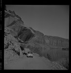
Colorado River - Bridge - at Moab | P0268 Frederick J. Pack photograph collection | P0268n01_13_018 |
| 21 |
 |
Colorado River below Moab, 1926 [01] | P0268 Frederick J. Pack photograph collection | P0268n01_13_452 |
| 22 |
 |
Colorado River bridge at Moab, 1926 | P0268 Frederick J. Pack photograph collection | P0268n01_13_453 |
| 23 |
 |
Colorado River below Moab, 1926 [02] | P0268 Frederick J. Pack photograph collection | P0268n01_13_454 |
| 24 |
 |
Colorado River below Moab, 1926 [03] | P0268 Frederick J. Pack photograph collection | P0268n01_13_455 |
| 25 |
 |
Colorado River below Moab, 1926 [18] | P0268 Frederick J. Pack photograph collection | P0268n01_13_506 |