Home
Browse
Ask Us
Chat
Harmful Language Statement
Log in
Photo Archives
Advanced Search
About
Over 70,000 photos covering a variety of topics from Marriott Library Special Collections
Year
1845
1846
1847
1848
1849
1850
1851
1852
1853
1854
1855
1856
1857
1858
1859
1860
1861
1862
1863
1864
1865
1866
1867
1868
1869
1870
1871
1872
1873
1874
1875
1876
1877
1878
1879
1880
1881
1882
1883
1884
1885
1886
1887
1888
1889
1890
1891
1892
1893
1894
1895
1896
1897
1898
1899
1900
1901
1902
1903
1904
1905
1906
1907
1908
1909
1910
1911
1912
1913
1914
1915
1916
1917
1918
1919
1920
1921
1922
1923
1924
1925
1926
1927
1928
1929
1930
1931
1932
1933
1934
1935
1936
1937
1938
1939
1940
1941
1942
1943
1944
1945
1946
1947
1948
1949
1950
1951
1952
1953
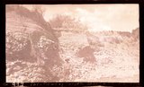
1954
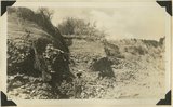
1955
1956
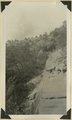
1957
1958
1959
1960
1961
1962
1963
1964
1965
1966
1967
1968
1969
1970
1971
1972
1973
1974
1975
1976
1977
1978
1979
1980
1981
1982
1983
1984
1985
1986
1987
1988
1989
1990
TO
1845
1846
1847
1848
1849
1850
1851
1852
1853
1854
1855
1856
1857
1858
1859
1860
1861
1862
1863
1864
1865
1866
1867
1868
1869
1870
1871
1872
1873
1874
1875
1876
1877
1878
1879
1880
1881
1882
1883
1884
1885
1886
1887
1888
1889
1890
1891
1892
1893
1894
1895
1896
1897
1898
1899
1900
1901
1902
1903
1904
1905
1906
1907
1908
1909
1910
1911
1912
1913
1914
1915
1916
1917
1918
1919
1920
1921
1922
1923
1924
1925
1926
1927
1928
1929
1930
1931
1932
1933
1934
1935
1936
1937
1938
1939
1940
1941
1942
1943
1944
1945
1946
1947
1948
1949
1950
1951
1952
1953
1954
1955
1956
1957
1958
1959
1960
1961
1962
1963
1964
1965
1966
1967
1968
1969
1970
1971
1972
1973
1974
1975
1976
1977
1978
1979
1980
1981
1982
1983
1984
1985
1986
1987
1988
1989
1990
Type
Image
2,290
Format
image/jpeg
2,117
application/pdf
173
Collection Name
Shipler Studio
609
Emigration Canyon History
277
William F. Bulkley
173
Deseret Livestock Company
147
Charles Neal
118
Everett Ruess Family
116
Olive Woolley Burt
99
George D. Pyper
85
Mining Photograph Collection
83
Herbert E. Gregory
73
Albion W. and Agnes Sharp Caine
69
G. Bennet Larson
51
Greek Archives
45
Reo Robbins
44
Alta Club
33
Charles Kelly
32
Fort Douglas
29
Waldo Wilcox
18
Rocky Mountain Power Company
16
Leo Leonard
14
Melba Goff Matthews
14
Combined Metals Reduction Company
13
Joe Hill Conference
13
Millard F. Malin Photographs
13
Wallace Stegner
12
Henry Y. Kasai
10
Vyrie Gray
9
Geraldine Palmer Jones
8
Utah Postcard
8
Hope A. Hilton
6
Preston Nutter Corporation
6
Reva Beck Bosone
6
Provo, Utah
5
Wasatch Mountain Club
5
Seamount Family
4
Kunio Yamada digital photograph collection
3
Southern Slavic
3
William Caine Patrick
3
Bingham Stage Lines
2
Japanese Church of Christ
2
Philip T. Blair
2
Agnes Just Reid
1
Allen Publishing Company
1
Colorado
1
Hiram B. Clawson
1
Italian
1
John Esplin
1
Lyman P. Hunter
1
Mike M. Masaoka
1
Miles Pratt Romney
1
Ole Pettit
1
U of U Presidents
1
Works Progress Administration
1
More
Filters:
Date:
"1934"
Collection:
"uum_map"
Type:
"Image"
101
-
125
of
2,290
<
1
2
3
4
5
6
7
8
9
10
>
Gallery view
Number of results to display per page
10
25
50
100
200
Sort by Relevance
Sort by Title A-Z
Sort by Title Z-A
Sort by Date Ascending
Sort by Date Descending
Sort by Last Modified Ascending
Sort by Last Modified Descending
Sort by Photo Number
Title
Collection Number And Name
Photo Number
101
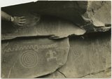
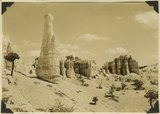
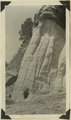
Indian pictographs near Mt. Carmel road.
P0013 Herbert E. Gregory Photograph Collection
P0013n10_061_2192
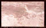
102
Village of Hurricane, Utah, from Hurricane Hill. Cinder cones in middle distance. Pine Valley Mountain on horizon. Fertility in foreground.
P0013 Herbert E. Gregory Photograph Collection
P0013n10_062_2193
103
Old abandoned cotton mill at Washington, Utah.
P0013 Herbert E. Gregory Photograph Collection
P0013n10_062_2194
104
View of the Virgin River a few miles below the mouth of Zion Canyon, showing washed-out banks where farms once stood. Village of Grafton on the opposite side was once the center of a farming area.
P0013 Herbert E. Gregory Photograph Collection
P0013n10_063_2195
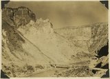
105
View from the top of the Hurricane Fault (La Verkin Hill), showing Pine Valley Mountain in the distance; the Vermillion Cliff formation in the middle distance, which is the same formation as Zion only much lower on the west side of the Hurricane Fault.
P0013 Herbert E. Gregory Photograph Collection
P0013n10_063_2196
106
View of a branch of the Hurricane Fault showing tilted block on the left which tipped over between the forks with the main fault. Visible from highway at the summit of La Verkin Hill. Lava flow on top and sides of tilted block on left side of picture.
P0013 Herbert E. Gregory Photograph Collection
P0013n10_064_2197
107
The Hurricane Fault where it crosses the Virgin River. La Verkin Warm Sulphur Springs in canyon.
P0013 Herbert E. Gregory Photograph Collection
P0013n10_064_2198
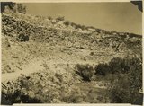
108
Shale formation where fossils are found. Near the Pine Creek bridge at the base of the switchboard on new Mt. Carmel road, Zion Canyon.
P0013 Herbert E. Gregory Photograph Collection
P0013n10_065_2199
109
The Virgin Mesa from top of Hurricane Hill.
P0013 Herbert E. Gregory Photograph Collection
P0013n10_066_2200
110
Virgin Mesa from highway below Rockville, Utah.
P0013 Herbert E. Gregory Photograph Collection
P0013n10_066_2201
111
Crossbedding of sandstone along Mt. Carmel road. Indicating wind action and sand dune formation prior to the formation of rock.
P0013 Herbert E. Gregory Photograph Collection
P0013n10_067_2202
112
Curvillinear fractures in sandstone, west wall of Temple of Sinawava, Zion Canyon.
P0013 Herbert E. Gregory Photograph Collection
P0013n10_068_2203
113
Wind and water erosion in sandstone. In Zion Canyon on west side of the Virgin River, about one-half mile above checking station.
P0013 Herbert E. Gregory Photograph Collection
P0013n10_069_2204
114
Half Arch. East side of Narrows, Zion Canyon, above Temple of Sinawava.
P0013 Herbert E. Gregory Photograph Collection
P0013n10_070_2205
115
Hidden Canyon from Observation Point. A typical hanging canyon or valley.
P0013 Herbert E. Gregory Photograph Collection
P0013n10_071_2206
116
Volcanic cone, two miles west of Hurricane, Utah.
P0013 Herbert E. Gregory Photograph Collection
P0013n10_071_2207
117
Lava flow over gravel wash. South of Toquerville, Utah, along main road from Zion Canyon to Anderson's Ranch.
P0013 Herbert E. Gregory Photograph Collection
P0013n10_072_2208
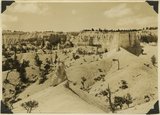
118
View southwest toward the rim of Bryce Canyon from the north side of lower canyon near the Fairy Temple trail.
P0013 Herbert E. Gregory Photograph Collection
P0013n10_074_2209
119
View east toward Seal Castle and Fairy Temple. "Lot's wife" in the foreground.
P0013 Herbert E. Gregory Photograph Collection
P0013n10_075_2210
120
View looking east across Parunuweap Valley near Mt. Carmel. Distance Elkheart Cliffs (Navajo capped by Carmel) on upthrown side of Sevier fault; middle distance erosion surface in Carmel and other Jurassic. Kane County, Utah, 1932.
P0013 Herbert E. Gregory Photograph Collection
P0013n10_116_2283
121
Recent cutting of alluvium fill, Parunuweap Canyon below Mt. Carmel, Kane County, Utah, 1932.
P0013 Herbert E. Gregory Photograph Collection
P0013n10_116_2284
122
Recent cutting of alluvium fill, Parunuweap Canyon below Mt. Carmel, Kane County, Utah, 1932.
P0013 Herbert E. Gregory Photograph Collection
P0013n10_116_2284
123
Sevier fault in small gulch 2± miles east of Mt. Carmel Junction. Navajo sandstone in right foreground (east), Carmel strata in left background. Kane County, Utah, 1932.
P0013 Herbert E. Gregory Photograph Collection
P0013n10_117_2285
124
Consolidated Pleistocene? Valley fill, gulch east of Mt. Carmel Junction. View taken standing on Carmel limestone. Kane County, Utah, 1932.
P0013 Herbert E. Gregory Photograph Collection
P0013n10_117_2286
125
Contact Jurassic and consolidated valley fill (Pleistocene?) in gulch east of Mt. Carmel Junction. Kane County, Utah, 1932.
P0013 Herbert E. Gregory Photograph Collection
P0013n10_118_2287
101
-
125
of
2,290
<
1
2
3
4
5
6
7
8
9
10
>