Home
Browse
Ask Us
Chat
Harmful Language Statement
Log in
Photo Archives
Advanced Search
About
Over 70,000 photos covering a variety of topics from Marriott Library Special Collections
Year
1943
1944
1945
TO
1943
1944
1945
Type
Image
71
Format
image/jpeg
71
Collection Name
Herbert E. Gregory
71
Filters:
Collection Name:
"Herbert E. Gregory"
Date:
"1944"
Format:
"image/jpeg"
Collection:
"uum_map"
1
-
25
of
71
<
1
2
3
>
Gallery view
Number of results to display per page
10
25
50
100
200
Sort by Relevance
Sort by Title A-Z
Sort by Title Z-A
Sort by Date Ascending
Sort by Date Descending
Sort by Last Modified Ascending
Sort by Last Modified Descending
Sort by Photo Number
Title
Collection Number And Name
Photo Number
1
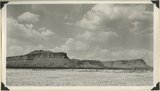
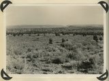
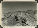
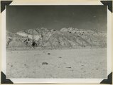
Vermillion Cliffs. Chinle formation. Petrified Forest member (foreground and basalt slopes) and upper sandstone. Flag Point, Kane County, UT. 1944
P0013 Herbert E. Gregory Photograph Collection
P0013n12_031_2879
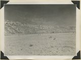
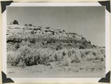
2
West wall of Seaman Wash
P0013 Herbert E. Gregory Photograph Collection
P0013n12_032_2880
3
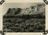
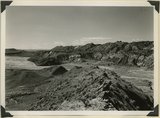
Vermillion Cliffs. Chinle formation. Petrified Forest member eroded into bedlands; upper sandstone capped by outliers of Wingate. Lower Road Creek. Kane County, UT, 1944
P0013 Herbert E. Gregory Photograph Collection
P0013n12_033_2881
4
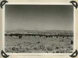
Looking southward across House Rock Valley from West Clark Bench. West dipping Navajo sandstone trenched by Kaibab Creek (middle distance) is a part of the East Kaibab monocline; east dipping limestones (skyline) are the cap rocks of the Kaibab upwarp. Kane County, UT, 1944
P0013 Herbert E. Gregory Photograph Collection
P0013n12_035_2882
5
Looking south, up dip, across West Clark Bench, Upper Jurassic and Dakota (butte), to the Paria Terrace, Navajo sandstone. Paria River, which passes through 'The Gap' is joined by Kaibab Creek. Kane County, UT. 1944
P0013 Herbert E. Gregory Photograph Collection
P0013n12_036_2883
6
Looking east across Paria River Canyon where it separates West and East Clark Benches. Upper Jurassic (foreground) and Navajo (background) dip northeast. Navajo Mountain and Kaiparowits Plateau are on opposite sides of Glen Canyon. Kane County, UT. 1944
P0013 Herbert E. Gregory Photograph Collection
P0013n12_037_2884
7
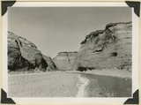
Looking south (up dip) down the Paria River, which has widened its floor and dissected its borders in Upper Jurassic rocks (foreground) and cut a deep narrow canyon in the Navajo sandstone (background). Site of the abandoned Adairville. Kane County UT, 1944
P0013 Herbert E. Gregory Photograph Collection
P0013n12_038_2885
8
Flat lying Upper Jurassic (foreground) and Cretaceous strata bed abruptly upward against the Navajo on the flank of the East Kaibab monocline (left sky line). Table Cliffs (right sky line) is about 50 miles north. Paria Valley near Adairville. Kane County, UT. 1944
P0013 Herbert E. Gregory Photograph Collection
P0013n12_039_2886
9
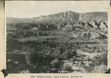
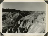
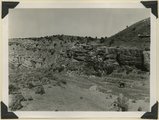
Eroded flank of the East Kaibab monocline at the junction of Paria River and Cottonwood Creek (left center). The sequence is Navajo (left), upper Jurassic (largely eroded), Dakota, Tropic, and Straight Cliffs. Kane County, UT, 1944
P0013 Herbert E. Gregory Photograph Collection
P0013n12_040_2887
10
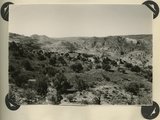
Looking south along Paria River from the mouth of Shurtz Gorge. Navajo sandstone in East Kaibab monocline is overlaid with decreasing dips by Upper Jurassic (banked against the Navajo), Dakota, and Tropic (foreground and left sky line). Erosion surface (middle distance) bevels upturned rocks. Kane County, UT, 1944
P0013 Herbert E. Gregory Photograph Collection
P0013n12_041_2888
11
Panorama {a}. Flank of East Kaibab monocline, bordering alluvial floor of Paria Valley. Navajo sandstone (middle sky line), Upper Jurassic strata, and basal Cretaceous (left). Dips of 40 degrees decrease to 3 degrees within 1,000 feet. Kane County, UT, 1944
P0013 Herbert E. Gregory Photograph Collection
P0013n12_042_2889
12
Panorama {b}. Flank of East Kaibab monocline, bordering alluvial floor of Paria Valley. Navajo sandstone (middle sky line), Upper Jurassic strata, and basal Cretaceous (left). Dips of 40 degrees decrease to 3 degrees within 1,000 feet. Kane County, UT, 1944
P0013 Herbert E. Gregory Photograph Collection
P0013n12_042_2890
13
Panorama {c}. Flank of East Kaibab monocline, bordering alluvial floor of Paria Valley. Navajo sandstone (middle sky line), Upper Jurassic strata, and basal Cretaceous (left). Dips of 40 degrees decrease to 3 degrees within 1,000 feet. Kane County, UT, 1944
P0013 Herbert E. Gregory Photograph Collection
P0013n12_042_2891
14
Panorama {d}. Flank of East Kaibab monocline, bordering alluvial floor of Paria Valley. Navajo sandstone (middle sky line), Upper Jurassic strata, and basal Cretaceous (left). Dips of 40 degrees decrease to 3 degrees within 1,000 feet. Kane County, UT, 1944
P0013 Herbert E. Gregory Photograph Collection
P0013n12_043_2892
15
Panorama {e}. Flank of East Kaibab monocline, bordering alluvial floor of Paria Valley. Navajo sandstone (middle sky line), Upper Jurassic strata, and basal Cretaceous (left). Dips of 40 degrees decrease to 3 degrees within 1,000 feet. Kane County, UT, 1944
P0013 Herbert E. Gregory Photograph Collection
P0013n12_043_2893
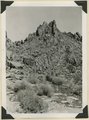
16
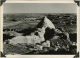
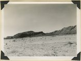
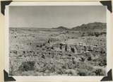
Pinnacles of Navajo sandstone in House Rock Valley along the course of Kaibab Creek. Eroded part of East Kaibab monocline. Kane County, UT, 1944
P0013 Herbert E. Gregory Photograph Collection
P0013n12_044_2894
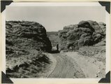
17
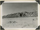
Gap cut in Navajo sandstone by Kaibab Creek where it leaves its structural valley to cross East Kaibab monocline. Northward through the gap House Rock Valley and Kaibab Plateau are visible. Kane County, UT. 1944
P0013 Herbert E. Gregory Photograph Collection
P0013n12_044_2895
18
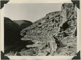
Joints and small faults in Navajo sandstone along the crest (Coxcomb) of East Kaibab monocline. Kane County, UT, 1944
P0013 Herbert E. Gregory Photograph Collection
P0013n12_045_2896
19
Paria River below White Rock Spring. Wall of Navajo sandstone capped by Carmel formation. Kane County, UT, 1944
P0013 Herbert E. Gregory Photograph Collection
P0013n12_046_2897
20
Paria river below White Rock Spring. Wall of Navajo sandstone capped by Carmel formation. Upper Jurassic rocks on right sky line. Kane County, UT, 1944
P0013 Herbert E. Gregory Photograph Collection
P0013n12_046_2898
21
Kaibab limestone (lower wall,left, breccia (marks unconformable contact), and basal Moenkopi limestone and shales. Mouth of Kaibab Gulch. Kane County, UT, 1944
P0013 Herbert E. Gregory Photograph Collection
P0013n12_047_2899
22
Permian limestones (Kaibab) overlain by the Triassic Moenkopi. Head of Kaibab Gulch, along Kanab-Paria road. Kane County, UT, 1944
P0013 Herbert E. Gregory Photograph Collection
P0013n12_049_2900
23
Timpoweap member of the Moenkopi formation. Kaibab at base, upstream. East rim of the Kaibab Plateau near the UT-AZ line. Coconino County, AZ, 1944
P0013 Herbert E. Gregory Photograph Collection
P0013n12_049_2901
24
View looking east from Kaibab Plateau across House Rock Valley (invisible) to the Coxcomb Navajo sandstone in the East Kaibab monocline. Timpoweap member of the Moenkopi forms walls of local gulch. Kane County, UT, 1944
P0013 Herbert E. Gregory Photograph Collection
P0013n12_050_2902
25
Shinarump Conglomerate at Pioneer Gap. Kane County, UT, 1944
P0013 Herbert E. Gregory Photograph Collection
P0013n12_050_2903
1
-
25
of
71
<
1
2
3
>