|
|
Title | Collection Number And Name | Photo Number |
| 151 |
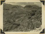 |
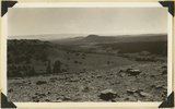
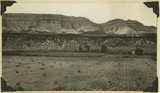
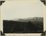
Hurricane Ledge fault zone. View northward from highway, crest of Hurricane Cliffs, west of Virgin City. Kaibab and lowest Moenkopi, right; Moenkopi shale, valley on left; lava capped Toquerville hills beyond it; Kaibab cliffs upper left; Pine Valley mountains left distance. Washington County, Utah, 1936. | P0013 Herbert E. Gregory Photograph Collection | P0013n10_204_2457 |
| 152 |
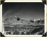 |
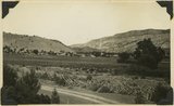
Zion Park Cliffs, from Shinarump bench, near base of Smithsonian Butte. Virgin River in middle distance; West Temple center distance; at the right Bridge Mountain, East Temple, The Twin Brothers, and Mountain of the Sun. Zion National Park, Utah, 1936. | P0013 Herbert E. Gregory Photograph Collection | P0013n10_205_2458 |
| 153 |
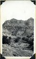 |
View of the Springdale member of the Chinle, on the west end of Smithsonian Butte. Kane County, Utah, 1936. | P0013 Herbert E. Gregory Photograph Collection | P0013n10_205_2459 |
| 154 |
 |
View of the Springdale member of the Chinle, on the west end of Smithsonian Butte. Kane County, Utah, 1936. | P0013 Herbert E. Gregory Photograph Collection | P0013n10_205_2460 |
| 155 |
 |
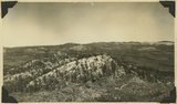
View southeast from top of Brian Head. Hancock Peak in center middle distance; Paunsaugunt Plateau on left horizon. Iron County, Utah, 1936. | P0013 Herbert E. Gregory Photograph Collection | P0013n10_209_2466 |
| 156 |
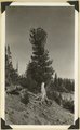 |
Roots of limber pine exposed by erosion, north rim of Cedar Breaks. Iron County, Utah, 1936. | P0013 Herbert E. Gregory Photograph Collection | P0013n10_210_2467 |
| 157 |
 |
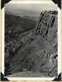
Moenkopi capped by Shinarump along road between Fruita and Capitol Wash. Shows pinon trees. Wayne County, Utah, 1936. | P0013 Herbert E. Gregory Photograph Collection | P0013n10_214_2474 |
| 158 |
 |
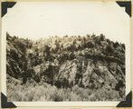
Jointing in Moenkopi sandstone, along road between Fruita on Capitol Wash. Wayne County, Utah, 1936. | P0013 Herbert E. Gregory Photograph Collection | P0013n10_214_2475 |
| 159 |
 |
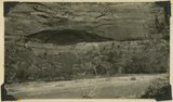
Basalt in Moenkopi, north wash. | P0013 Herbert E. Gregory Photograph Collection | P0013n10_217_2479 |
| 160 |
 |
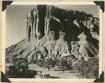
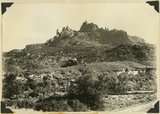
Elkheart Cliffs east of Mt. Carmel. | P0013 Herbert E. Gregory Photograph Collection | P0013n10_218_2480 |
| 161 |
 |
Same as 191 (Looking north across Orderville, Sevier fault), taken nearer Orderville. | P0013 Herbert E. Gregory Photograph Collection | P0013n10_218_2481 |
| 162 |
 |
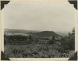
View NE across head of Kanab valley. Left, tilted Tertiary west of Sevier fault; right, Alton Cirque (lowland), above it, Pink Cliffs. | P0013 Herbert E. Gregory Photograph Collection | P0013n10_219_2482 |
| 163 |
 |
West edge Kolob plateau from New Harmony road. | P0013 Herbert E. Gregory Photograph Collection | P0013n10_219_2483 |
| 164 |
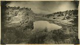 |
One of "Three Lakes," Kanab Canyon. | P0013 Herbert E. Gregory Photograph Collection | P0013n10_220_2484 |
| 165 |
 |
Cliff dweller niche, base of Navajo sandstone. Zion Park. | P0013 Herbert E. Gregory Photograph Collection | P0013n10_221_2486 |
| 166 |
 |
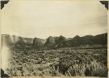
Eagle Crags. | P0013 Herbert E. Gregory Photograph Collection | P0013n10_221_2487 |
| 167 |
 |
Carmel on Navajo. Head of Parunuweap Canyon. | P0013 Herbert E. Gregory Photograph Collection | P0013n10_223_2488 |
| 168 |
 |
Coalpits volcano north of Grafton. | P0013 Herbert E. Gregory Photograph Collection | P0013n10_223_2489 |
| 169 |
 |
Volcano on Kolob plateau. | P0013 Herbert E. Gregory Photograph Collection | P0013n10_223_2490 |
| 170 |
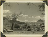 |
Remains of old town of Paria. | P0013 Herbert E. Gregory Photograph Collection | P0013n10_224_2491 |
| 171 |
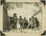 |
Mangum family with Herbert E. Gregory, Paria. | P0013 Herbert E. Gregory Photograph Collection | P0013n10_224_2492 |
| 172 |
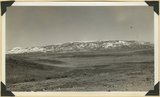 |
Thousand Lake Mountain, view from Loa eastward. Wayne Co., UT, 1936 | P0013 Herbert E. Gregory Photograph Collection | P0013n11_034_2580 |
| 173 |
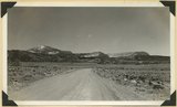 |
Cliffs north of highway west of Bicknell (right center). Moenkopi, Shinarump, Chinle, Wingate. Plain in foreground borders Fremont River. Wayne County, UT, 1936 | P0013 Herbert E. Gregory Photograph Collection | P0013n11_035_2581 |