Over 70,000 photos covering a variety of topics from Marriott Library Special Collections
TO
| Title | Collection Number And Name | Photo Number | ||
|---|---|---|---|---|
| 76 |
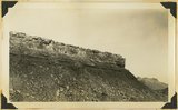 |
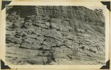
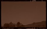
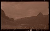
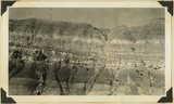
Moenkopi and Shinarump, Rockville, 1936. | P0013 Herbert E. Gregory Photograph Collection | P0013n10_150_2346 |
| 77 |
 |
Rockville 1936 | P0013 Herbert E. Gregory Photograph Collection | P0013n10_150_2346 |
| 78 |
 |
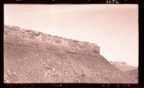
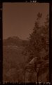
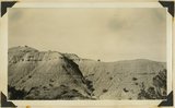
Cave Lakes Canyon, 1936 | P0013 Herbert E. Gregory Photograph Collection | P0013n10_151_2347 |
| 79 |
 |
Wingate local features, Cave Lakes Canyon, 1936. | P0013 Herbert E. Gregory Photograph Collection | P0013n10_151_2347 |
| 80 |
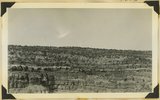 |
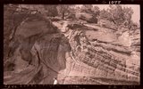
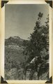
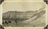
Banded Navajo sandstone near place where Wingate and Kayenta first lose their identity. Chinle immediately below. Two miles northwest of Pipe Springs, Mohave County, Arizona, 1936. | P0013 Herbert E. Gregory Photograph Collection | P0013n10_151_2348 |
| 81 |
 |
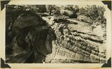
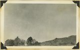
Kaibab Indian School looking north. Cliffs at left, Chinle capped by Wingate-Navajo. Cuesta at left, Moenkop capped by Shinarump. Mohave County, Arizona, 1936. | P0013 Herbert E. Gregory Photograph Collection | P0013n10_152_2349 |
| 82 |
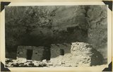 |
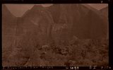
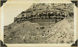
Cliff houses in branch of Cottonwood Canyon northwest of Kanab, Kane County, Utah, 1936. | P0013 Herbert E. Gregory Photograph Collection | P0013n10_153_2350 |
| 83 |
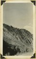 |
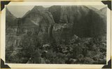
Front of landslide (entire picture) in Zion Canyon, mouth of Birch Creek, Washington County, Utah, 1936. | P0013 Herbert E. Gregory Photograph Collection | P0013n10_153_2351 |
| 84 |
 |
Wingate sandstone, Cottonwood Canyon, Kane County, Utah, 1936. | P0013 Herbert E. Gregory Photograph Collection | P0013n10_153_2352 |
| 85 |
 |
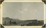
N.E. Pipe Springs | P0013 Herbert E. Gregory Photograph Collection | P0013n10_154_2353 |
| 86 |
 |
Navajo-Wingate on Chinle, 2 miles northeast Pipe Springs, 1936. | P0013 Herbert E. Gregory Photograph Collection | P0013n10_154_2353 |
| 87 |
 |
"Windsor Castle," Pipe Springs, 1936. | P0013 Herbert E. Gregory Photograph Collection | P0013n10_155_2354 |
| 88 |
 |
Pipe Springs | P0013 Herbert E. Gregory Photograph Collection | P0013n10_155_2354 |
| 89 |
 |
Sand dunes, head of Sand Canyon, 1936. | P0013 Herbert E. Gregory Photograph Collection | P0013n10_155_2355 |
| 90 |
 |
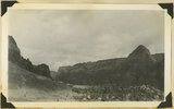
E. Birch Creek, Zion Canyon | P0013 Herbert E. Gregory Photograph Collection | P0013n10_156_2356 |
| 91 |
 |
Top of old landslide, east of Birch Creek, Zion Canyon, 1936. | P0013 Herbert E. Gregory Photograph Collection | P0013n10_156_2356 |
| 92 |
 |
Landslide (right) covered by talus, Zion Canyon, 1936. | P0013 Herbert E. Gregory Photograph Collection | P0013n10_156_2357 |
| 93 |
 |
Zion Canyon, 1936 | P0013 Herbert E. Gregory Photograph Collection | P0013n10_156_2357 |
| 94 |
 |
Chinle "marls," Sand Wash, Mohave County, Arizona, 1936. | P0013 Herbert E. Gregory Photograph Collection | P0013n10_157_2358 |
| 95 |
 |
Chinle "marls," Sand Wash, Mohave County, Arizona, 1936. | P0013 Herbert E. Gregory Photograph Collection | P0013n10_157_2359 |
| 96 |
 |
Chinle "marls," Sand Wash, Mohave County, Arizona, 1936. | P0013 Herbert E. Gregory Photograph Collection | P0013n10_158_2360 |
| 97 |
 |
Chinle "marls," Sand Wash, Mohave County, Arizona, 1936. | P0013 Herbert E. Gregory Photograph Collection | P0013n10_158_2361 |
| 98 |
 |
Chinle "marls," Sand Wash, Mohave County, Arizona, 1936. | P0013 Herbert E. Gregory Photograph Collection | P0013n10_159_2362 |
| 99 |
 |
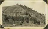
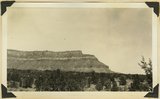
Sandstone ledges in upper part of Moenkopi. Shinarump conglomerate at extreme top. Rockville, Washington County, Utah, 1936. | P0013 Herbert E. Gregory Photograph Collection | P0013n10_159_2363 |
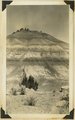
| 100 |
 |
Lambs Point. Chinle including prominent Springdale member from base to highest cliff step, which is combined Wingate and Navajo. Kane County, Utah, 1936. | P0013 Herbert E. Gregory Photograph Collection | P0013n10_160_2364 |