Home
Browse
Ask Us
Chat
Harmful Language Statement
Log in
Advanced Search
Year
1860
1861
1862
1863
1864
1865
1866
1867
1868
1869
1870
1871
1872
1873
1874
1875
1876
1877
1878
1879
1880
1881
1882
1883
1884
1885
1886
1887
1888
1889
1890
1891
1892
1893
1894
1895
1896
1897
1898
1899
1900
1901
1902
1903
1904
1905
1906
1907
1908
1909
1910
1911
1912
1913
1914
1915
1916
1917
1918
1919
1920
1921
1922
1923
1924
1925
1926
1927
1928
1929
1930
1931
1932
1933
1934
1935
1936
1937
1938
1939
1940
1941
1942
1943
1944
1945
1946
1947
1948
1949
1950
1951
1952
1953
1954
1955
1956
1957
1958
1959
1960
1961
1962
1963
1964
1965
1966
1967
1968
1969
1970
1971
1972
1973
1974
1975
1976
1977
1978
1979
1980
1981
1982
1983
1984
1985
1986
1987
1988
1989
1990
1991
1992
1993
1994
1995
1996
1997
1998
1999
2000
2001
2002
2003
2004
2005
2006
2007
2008
2009
2010
2011
2012
2013
2014
2015
2016
2017
2018
2019
2020
2021
TO
1860
1861
1862
1863
1864
1865
1866
1867
1868
1869
1870
1871
1872
1873
1874
1875
1876
1877
1878
1879
1880
1881
1882
1883
1884
1885
1886
1887
1888
1889
1890
1891
1892
1893
1894
1895
1896
1897
1898
1899
1900
1901
1902
1903
1904
1905
1906
1907
1908
1909
1910
1911
1912
1913
1914
1915
1916
1917
1918
1919
1920
1921
1922
1923
1924
1925
1926
1927
1928
1929
1930
1931
1932
1933
1934
1935
1936
1937
1938
1939
1940
1941
1942
1943
1944
1945
1946
1947
1948
1949
1950
1951
1952
1953
1954
1955
1956
1957
1958
1959
1960
1961
1962
1963
1964
1965
1966
1967
1968
1969
1970
1971
1972
1973
1974
1975
1976
1977
1978
1979
1980
1981
1982
1983
1984
1985
1986
1987
1988
1989
1990
1991
1992
1993
1994
1995
1996
1997
1998
1999
2000
2001
2002
2003
2004
2005
2006
2007
2008
2009
2010
2011
2012
2013
2014
2015
2016
2017
2018
2019
2020
2021
Type
Image/StillImage
56
Text
31
Image
11
Sound
2
Format
image/jpeg
62
application/pdf
33
Collection
Classified Photographs
5
Electronic University Archive
14
Graduate Nursing Project
1
Peoples of Utah Revisited
3
Regional History Center
3
Theses & Dissertations
1
Thorne Photographs
2
UAIDA Main Collection
10
Uintah County Regional History Center...
53
Utah Historical Society Oral History ...
2
Utah River Running Photo Archives
1
Vernal Express Photographs
1
More
Filters:
Subject:
"Colorado"
26
-
50
of
96
<
1
2
3
4
>
Gallery view
Number of results to display per page
10
25
50
100
200
Sort by Relevance
Sort by Title A-Z
Sort by Title Z-A
Sort by Date Ascending
Sort by Date Descending
Sort by Last Modified Ascending
Sort by Last Modified Descending
Title
Date
Type
Setname
26
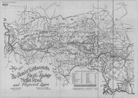
The Denver Northwestern and Pacific Railway, Moffat Road and Projected Lines 1911
1911
Image/StillImage
ucl_maps
27
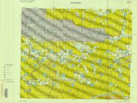
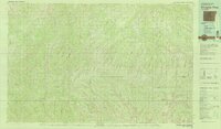
Dinosaur (Planimetric) NW-7 (US DOI BLM) 1975
1975
Image/StillImage
ucl_maps
28
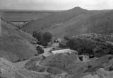
Dinosaur National Monument buildings
Image
ucl_tp
29
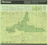
Dinosaur National Monument, 1986
1986
Image/StillImage
ucl_maps
30
Dinosaurland Bike Routes
Image/StillImage
ucl_maps
31
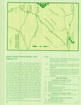
Dinosaurland Eastern Uintas Cross-Country Ski Trails
Image/StillImage
ucl_maps
32
Dinosaurland One-Day Self-Guided Tour #10 North Fork of the Duchesne River
Image/StillImage
ucl_maps
33
Dinosaurland One-Day Self-Guided Tour #11 Rock Creek and Upper Stillwater Dam
Image/StillImage
ucl_maps
34
Dinosaurland One-Day Self-Guided Tour #2 Indian Petroglyphs Dry Fork Canyon
Image/StillImage
ucl_maps
35
Dinosaurland One-Day Self-Guided Tour #4 Red Fleet & Steinaker Lake State Parks
Image/StillImage
ucl_maps
36
Dinosaurland One-Day Self-Guided Tour #5 Dinosaur National Monument, Quarry and Harper's Corner
Image/StillImage
ucl_maps
37
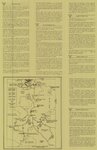
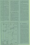
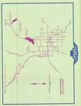
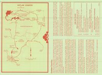
Dinosaurland One-Day Self-Guided Tour #6 Outlaw Country - Crouse Canyon, Brown's Park, Javie's Ranch, Jessie Ewing Canyon
Image/StillImage
ucl_maps
38
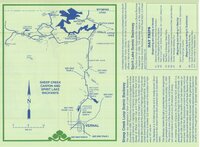
Dinosaurland One-Day Self-Guided Tour #8 Sheep Creek Canyon and Spirit Lake
Image/StillImage
ucl_maps
39
Dinosaurland One-Day Self-Guided Tour #9 Indian Canyon
Image/StillImage
ucl_maps
40
Dominguez - Escalante Expedition 1776 (Brochure and Map)
Image/StillImage
ucl_maps
41
Douglas Pass, Colorado 1981
1981
Image/StillImage
ucl_maps
42
Dutch John, Utah 1997
1997
Image/StillImage
ucl_maps
43
Dutch John, Utah-Colorado-Wyoming 1981
1981
Image/StillImage
ucl_maps
44
Dutch John, Utah-Colorado-Wyoming 1982
1981; 1982
Image/StillImage
ucl_maps
45
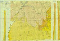
East Tavaputs, Utah - Colorado. Reprint edition of Dec. 1885 Map
1885
Image/StillImage
ucl_maps
46
Ecoshale: Environmental alternative fuels
2008-11-13
Text
ir_eua
47
Engaging Providers and Support Staff for Evidence-Based HPV Vaccination Practices in a Rural Colorado Community
2021
Text
ehsl_gradnu
48
Flaming Gorge Recreation Map - Ashley National Forest
1965
Image/StillImage
ucl_maps
49
Geologic Map of Uintah County, Utah - South Half - 1950s
1950; 1951; 1952; 1953; 1954; 1955; 1956; 1957; 1958; 1959
Image/StillImage
ucl_maps
50
Geological Map of the Dinosaur National Monument
1965
Image/StillImage
ucl_maps
26
-
50
of
96
<
1
2
3
4
>