|
|
Title | Collection Number And Name | Photo Number |
| 276 |
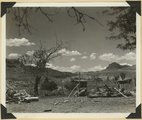 |
The village of Paria, abandoned. Kane County, UT, 1937 | P0013 Herbert E. Gregory Photograph Collection | P0013n11_006_2537 |
| 277 |
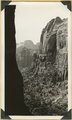
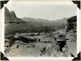 |
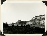
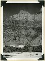
Site of Springdale, Virgin River Valley, below mouth of Zion Canyon. At left, the Watchman. Navajo sandstone, underlaid by Chinle: middle cliff is Springdale member. Washington County, UT | P0013 Herbert E. Gregory Photograph Collection | P0013n11_007_2538 |
| 278 |
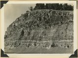 |
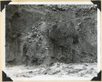
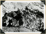
Contact Carmel limestone (top) and Navajo (bottom), between them calcareous and argillaceous shales. Kane County, UT | P0013 Herbert E. Gregory Photograph Collection | P0013n11_008_2539 |
| 279 |
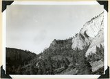 |
Lava flow over Navajo sandstone, near Pine Springs, Kolob Terrace. Washington County, UT | P0013 Herbert E. Gregory Photograph Collection | P0013n11_009_2540 |
| 280 |
 |
Wingate, Kayenta, and Navajo. Kanab Canyon 2+ miles above junction of Three Lakes. Kane County, UT | P0013 Herbert E. Gregory Photograph Collection | P0013n11_009_2541 |
| 281 |
 |
East wall Meadow Brook Canyon, near highway crossing. Carmel limestone (bottom), Entrada, Curtis, Winsor, Dakota (black band, upper left), base of Tropic shales. Kane County, UT | P0013 Herbert E. Gregory Photograph Collection | P0013n11_010_2542 |
| 282 |
 |
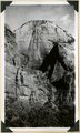
Navajo sandstone, above it (offset) Temple Cap member projected by Carmel limestone. View from base of East Temple. Washington County, UT | P0013 Herbert E. Gregory Photograph Collection | P0013n11_011_2543 |
| 283 |
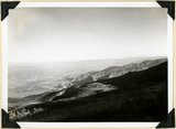 |
Near west edge of Kolob Terrace, looking northeast across mouth of Coal Creek; tilted rocks at Hurricane fault (middle); Cedar City, lower left. Iron County, UT | P0013 Herbert E. Gregory Photograph Collection | P0013n11_011_2544 |
| 284 |
 |
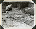
Virgin River in Zion National Park: rising flood from shower on Kolob Terrace | P0013 Herbert E. Gregory Photograph Collection | P0013n11_012_2545 |
| 285 |
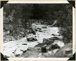 |
Virgin River in Zion National Park: rising flood from shower on Kolob Terrace | P0013 Herbert E. Gregory Photograph Collection | P0013n11_013_2546 |
| 286 |
 |
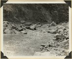
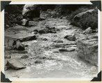
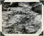
Virgin River in Zion National Park: flood stage | P0013 Herbert E. Gregory Photograph Collection | P0013n11_013_2547 |
| 287 |
 |
Virgin River in Zion National Park: flood stage | P0013 Herbert E. Gregory Photograph Collection | P0013n11_014_2548 |
| 288 |
 |
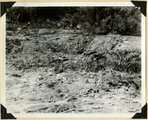
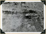
Virgin River in Zion National Park: erosion of land slide at flood stage | P0013 Herbert E. Gregory Photograph Collection | P0013n11_015_2549 |
| 289 |
 |
Stages of flood in branch of Parunuweap Canyon above Hidden Lake, result of local storm: beginning. Kane County, UT, 1937 | P0013 Herbert E. Gregory Photograph Collection | P0013n11_015_2550 |
| 290 |
 |
Stages of flood in branch of Parunuweap Canyon above Hidden Lake, result of local storm: rising water. Kane County, UT, 1937 | P0013 Herbert E. Gregory Photograph Collection | P0013n11_016_2551 |
| 291 |
 |
Stages of flood in branch of Parunuweap Canyon above Hidden Lake, result of local storm: high water. Kane County, UT, 1937 | P0013 Herbert E. Gregory Photograph Collection | P0013n11_016_2552 |
| 292 |
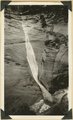 |
Ephemeral waterfall, disappears about half hour after rain. Pine Creek, Zion National Park, 1937 | P0013 Herbert E. Gregory Photograph Collection | P0013n11_022_2556 |
| 293 |
 |
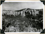
Alluvial terraces, Parunuweap Valley between Orderville and Mt. Carmel. Lie unevenly on Tropic shale. Kane County, UT. 1937 | P0013 Herbert E. Gregory Photograph Collection | P0013n11_022_2557 |
| 294 |
 |
Coal in the Dakota or basal Tropic; Coal hill east side Meadow Brook. Kane County, UT | P0013 Herbert E. Gregory Photograph Collection | P0013n11_023_2558 |
| 295 |
 |
Wasatch formation, head of Dairy Canyon, tributary to the Parunuweap. Kane County, UT | P0013 Herbert E. Gregory Photograph Collection | P0013n11_023_2559 |
| 296 |
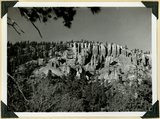 |
Wasatch formation, head of Dairy Canyon, tributary to the Parunuweap. Kane County, UT | P0013 Herbert E. Gregory Photograph Collection | P0013n11_024_2560 |
| 297 |
 |
Upper Chinle, Wingate, Kayenta, and Navajo formations on face of Bridge Mountain. Springdale member, ledge near base. Zion National Park, UT | P0013 Herbert E. Gregory Photograph Collection | P0013n11_024_2561 |
| 298 |
 |
Travertine formed by plants, narrows of Virgin River. Zion National Park, UT | P0013 Herbert E. Gregory Photograph Collection | P0013n11_025_2562 |
| 299 |
 |
Cable Mountain, Navajo sandstone. Location of East Rim trail (center). Zion National Park | P0013 Herbert E. Gregory Photograph Collection | P0013n11_025_2563 |
| 300 |
 |
Navajo sandstone viewed from tunnel window across Pine Creek. The Sentinel in distance. Zion National Park | P0013 Herbert E. Gregory Photograph Collection | P0013n11_026_2564 |