Over 70,000 photos covering a variety of topics from Marriott Library Special Collections
TO
Filters: Date: "1915" Collection: "uum_map"
| Title | Collection Number And Name | Photo Number | ||
|---|---|---|---|---|
| 201 |
 |
Hogan--permanent house of Navajo Indians | P0013 Herbert E. Gregory Photograph Collection | P0013n08_058_1413 |
| 202 |
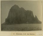 |
Shiprock, NW New Mexico | P0013 Herbert E. Gregory Photograph Collection | P0013n08_058_1414 |
| 203 |
 |
Navajo Indians at Shiprock | P0013 Herbert E. Gregory Photograph Collection | P0013n08_059_1415 |
| 204 |
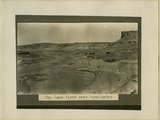 |
San Juan River, Farmington, NM | P0013 Herbert E. Gregory Photograph Collection | P0013n08_059_1416 |
| 205 |
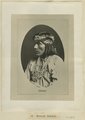 |
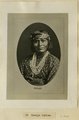
Navajo | P0013 Herbert E. Gregory Photograph Collection | P0013n08_060_1418 |
| 206 |
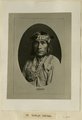 |
Navajo | P0013 Herbert E. Gregory Photograph Collection | P0013n08_061_1419 |
| 207 |
 |
Navajo | P0013 Herbert E. Gregory Photograph Collection | P0013n08_061_1420 |
| 208 |
 |
Escalante Valley and Village, looking east across the Village from a point one mile west. Garfield County, UT. June 1918 | P0013 Herbert E. Gregory Photograph Collection | P0013n08_104_1508 |
| 209 |
 |
Escalante Valley, looking northeast from a point one mile west of Escalante Village. Garfield County, UT. June 1918 | P0013 Herbert E. Gregory Photograph Collection | P0013n08_105_1509 |
| 210 |
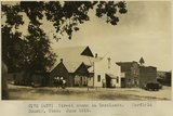 |
Street scene in Escalante. Garfield County, UT. June 1918 | P0013 Herbert E. Gregory Photograph Collection | P0013n08_105_1510 |
| 211 |
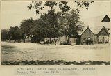 |
Street scene in Escalante. Garfield County, UT. June 1918 | P0013 Herbert E. Gregory Photograph Collection | P0013n08_106_1511 |
| 212 |
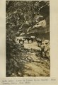 |
Scene in Silver Falls Canyon. Kane County, UT. June 1918 | P0013 Herbert E. Gregory Photograph Collection | P0013n08_106_1512 |
| 213 |
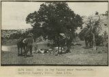 |
Camp in Dry Valley near Henrieville. Garfield County, UT. June 1918 | P0013 Herbert E. Gregory Photograph Collection | P0013n08_106_1513 |
| 214 |
 |
Escalante School House. United States Geological Survey headquarters 1918. Garfield County, UT. June 1918 | P0013 Herbert E. Gregory Photograph Collection | P0013n08_107_1514 |
| 215 |
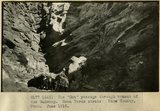 |
The 'Gut' passage through branch of the Wahweap. Mesa Verde strata. Kane County, UT. June 1918 | P0013 Herbert E. Gregory Photograph Collection | P0013n08_107_1515 |
| 216 |
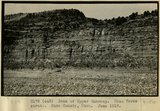 |
Bank of Upper Wahweap. Mesa Verde strata. Kane County, UT. June 1918 | P0013 Herbert E. Gregory Photograph Collection | P0013n08_107_1516 |
| 217 |
 |
Camp in Kanab Canyon 2 miles below mouth of Snake Gulch | P0013 Herbert E. Gregory Photograph Collection | P0013n08_164_1635 |
| 218 |
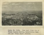 |
View east from rim of Bryce Canyon showing Kaiparowitz Peak and the Table Cliff Plateau | P0013 Herbert E. Gregory Photograph Collection | P0013n08_167_1654 |
| 219 |
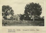 |
Mangum's hotel, Cannonville | P0013 Herbert E. Gregory Photograph Collection | P0013n08_167_1655 |
| 220 |
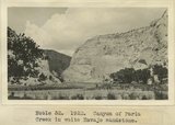 |
Canyon of Paria Creek in white Navajo sandstone | P0013 Herbert E. Gregory Photograph Collection | P0013n08_167_1656 |
| 221 |
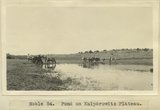 |
Pond on Kaiparowitz Plateau | P0013 Herbert E. Gregory Photograph Collection | P0013n08_173_1678 |
| 222 |
 |
Herbert E. Gregory Book 10: San Juan, Zion, Capitol Reef, 1915-1938 | P0013 Herbert E. Gregory Photograph Collection | P0013n10 |
| 223 |
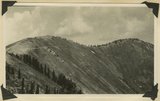 |
Extreme head of Gold Queen Gulch. Abajo Peak on the right. Slope composed of blue porphyry talus. Abajo Mountains. Utah, San Juan, 1915. | P0013 Herbert E. Gregory Photograph Collection | P0013n10_024_2126 |
| 224 |
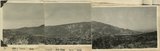 |
Shay Mountain, looking northwest across Indian Creek from the Abajo Mountain. Utah, San Juan, 1915. | P0013 Herbert E. Gregory Photograph Collection | P0013n10_024_2126ABC |
| 225 |
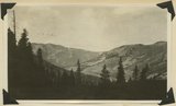 |
Head of Indian Creek, looking west. Mt. Linnaeus (West mountain) in left distance. Abajo Mountains. Utah, San Juan, 1915. | P0013 Herbert E. Gregory Photograph Collection | P0013n10_025_2127 |