|
|
Title | Collection Number And Name | Photo Number |
| 151 |
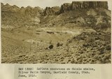 |
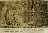
LaPlata sandstone on Chinle shales, Silver Falls Canyon, Garfield County, Utah, June, 1915. | P0013 Herbert E. Gregory Photograph Collection | P0013n08_025_1358 |
| 152 |
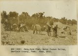 |
Camp, Burr Flat, Water Pocket Valley, Garfield County, Utah, June, 1915. | P0013 Herbert E. Gregory Photograph Collection | P0013n08_026_1359 |
| 153 |
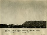 |
Water Pocket Monocline, Garfield County, Utah, looking N. 15 degrees W., June, 1915. | P0013 Herbert E. Gregory Photograph Collection | P0013n08_026_1360 |
| 154 |
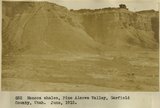 |
Mancos shales, Pine Alcove Valley, Garfield County, Utah, June, 1915. | P0013 Herbert E. Gregory Photograph Collection | P0013n08_027_1361 |
| 155 |
 |
Mancos shales, Pine Alcove Valley, Garfield County, Utah, June, 1915. | P0013 Herbert E. Gregory Photograph Collection | P0013n08_027_1362 |
| 156 |
 |
Mancos shales, Pine Alcove Valley, Garfield County, Utah, June, 1915. | P0013 Herbert E. Gregory Photograph Collection | P0013n08_028_1363 |
| 157 |
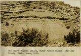 |
Mancos shales, Water Pocket Canyon, Garfield County, Utah, June, 1915. | P0013 Herbert E. Gregory Photograph Collection | P0013n08_028_1364 |
| 158 |
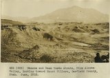 |
Mancos and Mesa Verde strata, Pine Alcove Valley, looking toward Mount Hillers, Garfield County, Utah, June, 1915. | P0013 Herbert E. Gregory Photograph Collection | P0013n08_029_1365 |
| 159 |
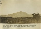 |
Mount Holmes looking southeast from base of Mount Hillers at Star Ranch, Garfield County, Utah, June, 1915. | P0013 Herbert E. Gregory Photograph Collection | P0013n08_029_1366 |
| 160 |
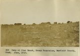 |
Camp at Star Ranch, Henry Mountains, Garfield County, Utah, June, 1915. | P0013 Herbert E. Gregory Photograph Collection | P0013n08_030_1367 |
| 161 |
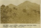 |
Mount Hillers looking north from Star Ranch, Garfield County, Utah, June, 1915. | P0013 Herbert E. Gregory Photograph Collection | P0013n08_030_1368 |
| 162 |
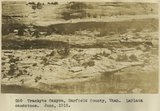 |
Trachyte Canyon, Garfield County, Utah. LaPlata sandstone, June, 1915 | P0013 Herbert E. Gregory Photograph Collection | P0013n08_031_1369 |
| 163 |
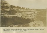 |
Trachyte Canyon, Garfield County, Utah. Walls of LaPlata sandstone, June, 1915 | P0013 Herbert E. Gregory Photograph Collection | P0013n08_031_1370 |
| 164 |
 |
Colorado River at Hite, Utah, June 1915 | P0013 Herbert E. Gregory Photograph Collection | P0013n08_032_1371 |
| 165 |
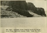 |
Colorado River looking south 3+ miles above Hite, Garfield County, Utah, June 19, 1915. | P0013 Herbert E. Gregory Photograph Collection | P0013n08_032_1372 |
| 166 |
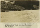 |
Crossing of Colorado River 3+ miles above Hite, Garfield County, Utah. Note horses swimming. June 19, 1915. | P0013 Herbert E. Gregory Photograph Collection | P0013n08_033_1373 |
| 167 |
 |
Camp south edge of Elk Ridge at head of Grand Gulch, San Juan County, Utah. June, 1915. | P0013 Herbert E. Gregory Photograph Collection | P0013n08_033_1374 |
| 168 |
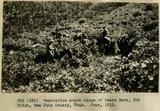 |
Vegetation south slope of Bears Ears, Elk Ridge, San Juan County, Utah. June, 1915. | P0013 Herbert E. Gregory Photograph Collection | P0013n08_034_1375 |
| 169 |
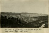 |
Canyon leading west from Elk Ridge, San Juan County, Utah. June, 1915. | P0013 Herbert E. Gregory Photograph Collection | P0013n08_034_1376 |
| 170 |
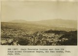 |
Abajo Mountains looking east from Elk Ridge across Cottonwood Canyon, San Juan County, Utah. June, 1915. | P0013 Herbert E. Gregory Photograph Collection | P0013n08_035_1377 |
| 171 |
 |
Camp, Bears Ears, Elk Ridge, Utah. June, 1915. | P0013 Herbert E. Gregory Photograph Collection | P0013n08_035_1378 |
| 172 |
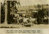 |
Sheep Camp, Cottonwood Canyon, Abajo Mountains, San Juan County, Utah. June, 1915. | P0013 Herbert E. Gregory Photograph Collection | P0013n08_036_1379 |
| 173 |
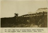 |
West wall of Allen Canyon, Abajo Mountains, San Juan County, Utah. McElmo strata. June, 1915. | P0013 Herbert E. Gregory Photograph Collection | P0013n08_036_1380 |
| 174 |
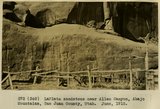 |
LaPlata sandstone near Allen Canyon, Abajo Mountains, San Juan County, Utah. June, 1915. | P0013 Herbert E. Gregory Photograph Collection | P0013n08_037_1381 |
| 175 |
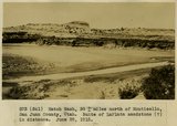 |
Hatch Wash, 30+ miles north of Monticello, San Juan County, Utah. Butte of LaPlata sandstone (?) in distance. June 28, 1915. | P0013 Herbert E. Gregory Photograph Collection | P0013n08_037_1382 |