|
|
Title | Collection Number And Name | Photo Number |
| 26 |
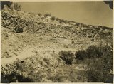 |
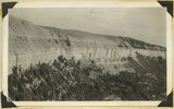
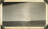
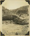
Lava flow over gravel wash. South of Toquerville, Utah, along main road from Zion Canyon to Anderson's Ranch. | P0013 Herbert E. Gregory Photograph Collection | P0013n10_072_2208 |
| 27 |
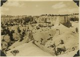 |
View southwest toward the rim of Bryce Canyon from the north side of lower canyon near the Fairy Temple trail. | P0013 Herbert E. Gregory Photograph Collection | P0013n10_074_2209 |
| 28 |
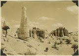 |
View east toward Seal Castle and Fairy Temple. "Lot's wife" in the foreground. | P0013 Herbert E. Gregory Photograph Collection | P0013n10_075_2210 |
| 29 |
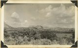 |
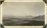
View looking west across valley cut in top Jurassic and Tropic shale (Cretaceous) at head of La Verkin Creek. In distance Timber top and other mesas of Navajo sandstone that form Hurrican Cliffs, Washington County, Utah, 1937. | P0013 Herbert E. Gregory Photograph Collection | P0013n10_166_2377 |
| 30 |
 |
Tropic shale, Cretaceous, head of La Verkin Canyon. Washington County, Utah, 1937. | P0013 Herbert E. Gregory Photograph Collection | P0013n10_167_2378 |
| 31 |
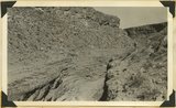 |
Timpoweap Canyon (Virgin River); Kaibab formation in bed of stream; conglomerate on rim, thin Kaibab; Timpoweap member of Moenkopi in cliffs. Washington County, Utah, 1937. | P0013 Herbert E. Gregory Photograph Collection | P0013n10_167_2379 |
| 32 |
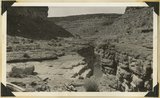 |
Timpoweap Canyon, Virgin River, bedded conglomerate between beds of Kaibab limestone. Washington County, Utah, 1937. | P0013 Herbert E. Gregory Photograph Collection | P0013n10_168_2380 |
| 33 |
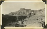 |
Looking north across Timpoweap Canyon: foreground Kaibab; middle flat, base of Moenkopi red shales; distance, Moenkopi capped by Shinarump; platform at upper left, Virgin limestone member. Washington County, Utah, 1937. | P0013 Herbert E. Gregory Photograph Collection | P0013n10_169_2381 |
| 34 |
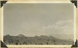 |
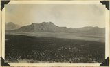
Row of basalt capped Moenkopi mesas near the crest of Hurricane Cliffs south of Hurricane; Sugar loaf in lower right; Pine Valley Mountain. Washington County, Utah, 1937. | P0013 Herbert E. Gregory Photograph Collection | P0013n10_169_2382 |
| 35 |
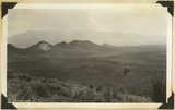 |
Same as 795 (Row of basalt capped Moenkopi mesas near the crest of Hurricane Cliffs south of Hurricane; Sugar loaf in lower right; Pine Valley Mountain) but showing also in foreground Workman Wash border by low cliffs of Virgin limestone, Moenkopi. Washington County, Utah, 1937. | P0013 Herbert E. Gregory Photograph Collection | P0013n10_170_2383 |
| 36 |
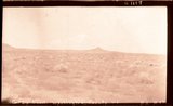 |
Gray Knoll, Washington County, Ut. | P0013 Herbert E. Gregory Photograph Collection | P0013n10_170_2384 |
| 37 |
 |
Sugar Loaf looking northwest from flat along Workman Wash. Washington County, Utah, 1937. | P0013 Herbert E. Gregory Photograph Collection | P0013n10_170_2384 |
| 38 |
 |
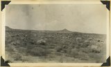
Gray Knoll, volcanic cone on Little Creek Mountain. General surface of Shinarump conglomerate; Moenkopi low cliffs in foreground. Washington County, Utah, 1937. | P0013 Herbert E. Gregory Photograph Collection | P0013n10_171_2385 |
| 39 |
 |
View looking west toward Canaan Gap of Short Creek. Road on Arizona-Utah line; foreground, flat cut in lowest Chinle beds; background, cliffs and ridges of eastward dipping Shinarump overlying Moenkopi. Washington County, Utah, 1937. | P0013 Herbert E. Gregory Photograph Collection | P0013n10_171_2386 |
| 40 |
 |
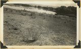
Short Creek near village of Short Creek. Cutting of its channel 20-30 feet done since about 1885. Mohave County, Arizona, 1937. | P0013 Herbert E. Gregory Photograph Collection | P0013n10_172_2387 |
| 41 |
 |
Same as 799 (Short Creek near village of Short Creek. Cutting of its channel 20-30 feet done since about 1885. Mohave County, Arizona, 1937). Point of Vermillion Cliff in upper left. | P0013 Herbert E. Gregory Photograph Collection | P0013n10_172_2388 |
| 42 |
 |
View looking across valley of Little Creek. Shinarump capped cliffs along stream. Smithsonian Butte (left). Navajo Cliffs of Zion Park north across Virgin River. Washington County, Utah, 1937. | P0013 Herbert E. Gregory Photograph Collection | P0013n10_173_2389 |
| 43 |
 |
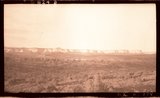
Looking across Big Plains toward Smithsonian Butte (middle background), West Temple (upper right). Foreground forested east slope of Little Creek Mountain, Shinarump; middle distance, dry farm lands on Chinle strata. Washington County, Utah, 1937. | P0013 Herbert E. Gregory Photograph Collection | P0013n10_173_2390 |
| 44 |
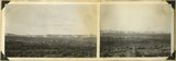 |
Block mesas from the south, panorama. | P0013 Herbert E. Gregory Photograph Collection | P0013n10_174_2391 |
| 45 |
 |
Block mesas from south, panorama. | P0013 Herbert E. Gregory Photograph Collection | P0013n10_174_2391A |
| 46 |
 |
Block mesas from south, panorama. | P0013 Herbert E. Gregory Photograph Collection | P0013n10_174_2391B |
| 47 |
 |
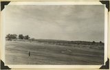
Flax Lake, one of five in landslide northeast of Glendale. Foreground floor of once larger lake. Kane County, Utah, 1937. | P0013 Herbert E. Gregory Photograph Collection | P0013n10_175_2392 |
| 48 |
 |
Wingate, Kayenta, Navajo, Kanab Canyon. | P0013 Herbert E. Gregory Photograph Collection | P0013n10_175_2393 |
| 49 |
 |
Tower in Navajo sandstone, outlier of White Cliffs, Kanab Valley, Kane County, Utah, 1937. | P0013 Herbert E. Gregory Photograph Collection | P0013n10_175_2394 |
| 50 |
 |
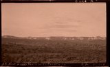
Plateau south of Block Mesas | P0013 Herbert E. Gregory Photograph Collection | P0013n10_176_2395 |