Home
Browse
Ask Us
Chat
Harmful Language Statement
Log in
Advanced Search
Year
1915
1916
1917
1918
1919
1920
1921
1922
1923
1924
1925
1926
1927
1928
1929
1930
1931
1932
1933
1934
1935
1936
1937
1938
1939
1940
1941
1942
1943
1944
1945
1946
1947
1948
1949
1950
1951
1952
1953
1954
1955
1956
1957
1958
1959
1960
1961
1962
1963
1964
1965
1966
1967
1968
1969
1970
1971
1972
1973
1974
1975
1976
1977
1978
1979
1980
1981
1982
1983
1984
1985
1986
1987
1988
1989
1990
1991
1992
1993
1994
1995
1996
1997
1998
1999
2000
2001
2002
TO
1915
1916
1917
1918
1919
1920
1921
1922
1923
1924
1925
1926
1927
1928
1929
1930
1931
1932
1933
1934
1935
1936
1937
1938
1939
1940
1941
1942
1943
1944
1945
1946
1947
1948
1949
1950
1951
1952
1953
1954
1955
1956
1957
1958
1959
1960
1961
1962
1963
1964
1965
1966
1967
1968
1969
1970
1971
1972
1973
1974
1975
1976
1977
1978
1979
1980
1981
1982
1983
1984
1985
1986
1987
1988
1989
1990
1991
1992
1993
1994
1995
1996
1997
1998
1999
2000
2001
2002
Type
Image
101
Text
2
Format
image/jpeg
100
application/pdf
1
Collection
Beckwith Photograph Collection
8
Classified Photographs
52
Clifton Bray Film Negatives
10
Extractions from the Land: Mining and...
2
Olympic Legacy
5
Peoples of Utah Revisited
2
Photo Archives
8
Shipler Commercial Photographers
6
Ski and Snow Sports Archives
1
Vernal Express Photographs
2
Westminster College Photographs
5
More
Filters:
Subject:
"Maps"
Type:
"Image"
26
-
50
of
101
<
1
2
3
4
5
>
Gallery view
Number of results to display per page
10
25
50
100
200
Sort by Relevance
Sort by Title A-Z
Sort by Title Z-A
Sort by Date Ascending
Sort by Date Descending
Sort by Last Modified Ascending
Sort by Last Modified Descending
Title
Date
Type
Setname
26
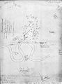
El Palacio, volume 30, nos.19-20 (May 20, 1931) [02]: Map, Nine Mile Canyon
1931-05-20
Image
dc_bpc
27
Emigrant Road from Independence to San Fran. P.1
Image
dha_cp
28
Escalante Map P.1
Image
dha_cp
29
Escalante Route Map P.1
Image
dha_cp
30
Escalante Valley Improvement Company Map
1915-11-19
Image
dha_scp
31
Escalante, Utah--Map P.1
Image
dha_cp
32
Fort Bridger P.1
Image
dha_cp
33
Fort Douglas Utah Territory P.1
Image
dha_cp
34
Fur Traders' Route (Peter Skene Ogden) P.1
Image
dha_cp
35
Great Salt Lake P.1
Image
dha_cp
36
Great Salt Lake P.2
Image
dha_cp
37
Great Salt Lake City P.1
Image
dha_cp
38
Great Salt Lake--Ferris P.1
Image
dha_cp
39
Great Salt Lake--Trails of Charles Stoddard P.1
Image
dha_cp
40
The Green & Colorado Rivers P.1
Image
dha_cp
41
Gunnison Massacre [19] : Map accompanying a transcript of part of Josiah Gibbs' account, from "Lights and Shadows of Mormonism" (1909), pp. 176-189
1926
Image
dc_bpc
42
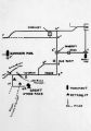
Gunnison Massacre--Site P.1
Image
dha_cp
43
Harrisburg Mining District P.1
Image
dha_cp
44
Hastings Cutoff--Map P.1
Image
dha_cp
45
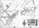
Host City map of downtown
2002
Image
dha_olyleg
46
Jeremy Ranch--Map P.1
Image
dha_cp
47
Joe's grandfather, Leo Frazier scrapbook
1985
Image; Text
dha_pour
48
Johnston's Army P.1
Image
dha_cp
49
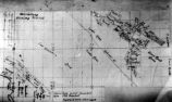
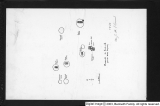
Kanosh, Black Rock, Pumice and Connor Spring scrapbook [02] : Kanosh mounds inside cover
1930
Image
dc_bpc
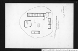
50
Kanosh, Black Rock, Pumice and Connor Spring scrapbook [03] : Kanosh mounds
1930
Image
dc_bpc
26
-
50
of
101
<
1
2
3
4
5
>