TO
1 - 25 of 14
| Author | Title | Subject | Date | Publication Type | ||
|---|---|---|---|---|---|---|
| 1 |
 | Higby Halseth, Deanna Renee | A paleolimnological investigation of historical environmental change in East Canyon Reservoir | East Canyon Reservoir; Paleolimnology; Remote sensing; Reservoir; Utah; Water resources | 2011-05 | thesis |
| 2 |
 | Zhang, Yuan | A rangeland predictive phenological model for the upper Colorado River Basin and its web delivery | Decision support system; Multivariate adaptive regression splines; Phenological modeling; Phenology; Remote sensing; Upper Colorado River Basin | 2013-08 | dissertation |
| 3 |
 | Tung, Kryztopher David | A real-time method for evaluating and monitoring heat stress potential using wearable Biosensors | Information Technology; Labor relations; Mechanical engineering; Occupational safety; Public health; Range management; Remote sensing; Thermodynamics | 2018 | dissertation |
| 4 |
 | Zhao, Yang | Cirrus particle size distribution bimodality derived from ground-based radar-lidar retrievals | Cirrus cloud; Remote sensing; Cirrus particle size; Bimodality; Radar; Lidar | 2011-05 | thesis |
| 5 |
 | Matheson, Daniel Scott | Evaluating the effects of spatial resolution on hyperspectral fire detection and temperature retrieval | Physical geography; Geographic information science; Remote sensing | 2011-08 | thesis |
| 6 |
 | Burgess, Evan Windam | Ice flow dynamics of Alaska glaciers | Alaska; Glaciers; Glaciology; Ice dynamics; Offset tracking; Remote sensing | 2013-05 | dissertation |
| 7 |
 | Olson, Matthew Howard | Impacts of topographic shading on surface energy balance of High Mountain Asia glaciers | Climate Change; Atmospheric sciences; Remote sensing | 2017 | thesis |
| 8 |
 | Jin, Zhenyu | Mapping and spatial-temporal modeling of Bromus tectorum invasion in Central Utah | Cheatgrass; NDVI time-series; Remote sensing; Spatial-temporal modeling; Utah; Bromus tectorum | 2011-11 | dissertation |
| 9 |
 | Eichorn, Michael | Master of Geographic Information Science Portfolio | Geography--Research--United States; Remote sensing | 2017 | online portfolio |
| 10 |
 | Wenrich, Erika Ann | Quantifying drought-induced changes in green vegetation fraction and classification accuracy using hyperspectral data for the Central Sierra Nevada, California | Geography; Forestry; Remote sensing | 2017 | thesis |
| 11 |
 | Housman, Ian Wilson | Recent trends in the changing geographic extent of Cienegas of the United States/Mexico border region | Ciénega; Desiccation; GIS; Landsat; Remote sensing; Wetlands | 2011-05 | thesis |
| 12 |
 | Campbell, Michael James | Remote sensing and geospatial modeling of wildland firefighter safety | Remote sensing | 2018 | dissertation |
| 13 |
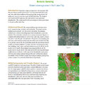 | Remote sensing: green coverage area in Salt Lake City | Geography--Research--United States; Remote sensing | online portfolio | ||
| 14 |
 | Mascio, Jeana Rose | Using an optimal estimation algorithm to describe the mass-dimensional properties of ice clouds | Atmospheric sciences; Remote sensing | 2018 | dissertation |
1 - 25 of 14