|
|
Title | Collection Number And Name | Photo Number |
| 76 |
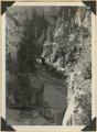 |
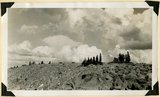
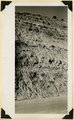
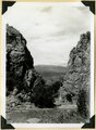
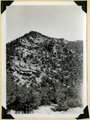
Panorama of Ashdown Canyon, 600-1800 feet deep, 20-150 feet wide out in Straight Cliffs sandstone. Iron County, UT, 1941 | P0013 Herbert E. Gregory Photograph Collection | P0013n11_152_2760 |
| 77 |
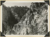 |
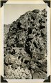
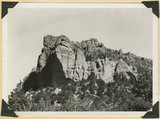
Straight Cliffs sandstone (Cretaceous) Wall of Ashdown Canyon, Iron County, UT. 1941 | P0013 Herbert E. Gregory Photograph Collection | P0013n11_152_2761 |
| 78 |
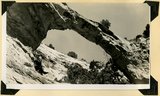 |
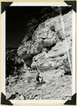
Natural bridge near top of wall of Ashdown Canyon, Iron County, UT, 1941 | P0013 Herbert E. Gregory Photograph Collection | P0013n11_153_2762 |
| 79 |
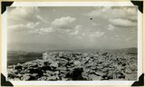 |
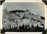
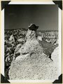
Top of Brian Head (11,280 feet) showing fracture of rhyolite by frost. Iron County, UT. 1941 | P0013 Herbert E. Gregory Photograph Collection | P0013n11_154_2763 |
| 80 |
 |
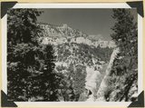
Top of ridge near head of Lauder Valley showing frost work and vegetation on Markagunt Plateau at altitudes between 10,000 and 11,000 feet. Iron County, UT, 1941 | P0013 Herbert E. Gregory Photograph Collection | P0013n11_154_2764 |
| 81 |
 |
Volcanic Conglomerate at the base of a succession of lavas on the cliff face of Brian Head. Iron County, UT. 1941 | P0013 Herbert E. Gregory Photograph Collection | P0013n11_155_2765 |
| 82 |
 |
Kaiparowits formation, head of Deep Creek, Iron County, UT. 1941 | P0013 Herbert E. Gregory Photograph Collection | P0013n11_155_2766 |
| 83 |
 |
Kaiparowits formation near southwest corner of Cedar Breaks National Monument. Iron County, UT. 1941 | P0013 Herbert E. Gregory Photograph Collection | P0013n11_156_2767 |
| 84 |
 |
Kaiparowits formation on Cedar City, Cedar Breaks road above Wood's Ranch. Iron County, UT. 1941 | P0013 Herbert E. Gregory Photograph Collection | P0013n11_156_2768 |
| 85 |
 |
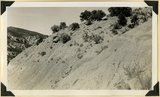
Glacial till, Castle Creek below Sidney Valley. Top of Markagunt Plateau. Iron County, UT. 1941 | P0013 Herbert E. Gregory Photograph Collection | P0013n11_157_2769 |
| 86 |
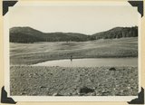 |
Sidney Valley. Ponds and mounds produced by glaciation. Iron County | P0013 Herbert E. Gregory Photograph Collection | P0013n11_157_2770 |
| 87 |
 |
Sidney Valley. Ponds and mounds produced by glaciation. Iron County | P0013 Herbert E. Gregory Photograph Collection | P0013n11_158_2771 |
| 88 |
 |
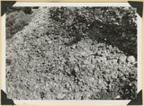
Talus of blocks from basalt sheet. Square Mountain. Iron County, UT. 1941 | P0013 Herbert E. Gregory Photograph Collection | P0013n11_158_2772 |
| 89 |
 |
Mouth of Camp Creek. Resistant limestones of lowest Triassic make walls. Iron County, UT. 1941 | P0013 Herbert E. Gregory Photograph Collection | P0013n11_159_2773 |
| 90 |
 |
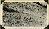
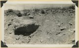
Contact of Triassic and Permian (beds in wall wrinkled at base). Cherty limestone lower left. Camp Creek. Iron County, UT. 1941 | P0013 Herbert E. Gregory Photograph Collection | P0013n11_159_2774 |
| 91 |
 |
Conglomerates, base of Timpoweep member of the Moenkopi Tarper Creek. Washington County, UT. 1941 | P0013 Herbert E. Gregory Photograph Collection | P0013n11_160_2775 |
| 92 |
 |
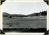
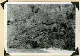
Surface of Kolob Terrace looking southeast near Pryor Knoll, Iron County, UT. 1941 | P0013 Herbert E. Gregory Photograph Collection | P0013n11_160_2776 |
| 93 |
 |
Same as 2776. Looking northeast to edge of Markagunt Plateau | P0013 Herbert E. Gregory Photograph Collection | P0013n11_161_2777 |
| 94 |
 |
Same as 2776. Looking north across Coal Creek Canyon. Sugar Loaf on middle skyline | P0013 Herbert E. Gregory Photograph Collection | P0013n11_161_2778 |
| 95 |
 |
Kaiparowits formation Cretaceous. Conglomerate (pinnacles) in contact with bedded arkosie sandstone. Parowan Canyon. Iron Co | P0013 Herbert E. Gregory Photograph Collection | P0013n11_162_2779 |
| 96 |
 |
Same as 2779. Detail contact of conglomerate (foreground) and rough bedded, carbonaceous sandstone above | P0013 Herbert E. Gregory Photograph Collection | P0013n11_163_2780 |
| 97 |
 |
Same as 2779. Detail contact of conglomerate (foreground) and rough bedded, carbonaceous sandstone above | P0013 Herbert E. Gregory Photograph Collection | P0013n11_163_2781 |
| 98 |
 |
Same as 2779. Detail contact of conglomerate (foreground) and rough bedded, carbonaceous sandstone above | P0013 Herbert E. Gregory Photograph Collection | P0013n11_164_2782 |
| 99 |
 |
Kaiparowits formation unconformable below Wasatch limestone south, foot of Parowan Canyon, Iron County, UT. 1941 | P0013 Herbert E. Gregory Photograph Collection | P0013n11_164_2783 |
| 100 |
 |
Undifferentiated Cretaceous formation near mouth of Parowan Canyon. Iron County, UT | P0013 Herbert E. Gregory Photograph Collection | P0013n11_165_2784 |