Home
Browse
Ask Us
Chat
Harmful Language Statement
Log in
Advanced Search
Year
1920
1921
1922
1923
1924
1925
1926
1927
1928
1929
1930
1931
1932
1933
1934
1935
1936
1937
1938
1939
1940
1941
1942
1943
1944
1945
1946
1947
1948
1949
1950
1951
1952
1953
1954
1955
1956
1957
1958
1959
1960
1961
1962
1963
1964
1965
1966
1967
1968
1969
1970
1971
1972
1973
1974
1975
1976
1977
1978
1979
1980
1981
1982
1983
1984
1985
1986
1987
1988
1989
1990
1991
1992
1993
1994
1995
1996
1997
1998
1999
2000
2001
2002
TO
1920
1921
1922
1923
1924
1925
1926
1927
1928
1929
1930
1931
1932
1933
1934
1935
1936
1937
1938
1939
1940
1941
1942
1943
1944
1945
1946
1947
1948
1949
1950
1951
1952
1953
1954
1955
1956
1957
1958
1959
1960
1961
1962
1963
1964
1965
1966
1967
1968
1969
1970
1971
1972
1973
1974
1975
1976
1977
1978
1979
1980
1981
1982
1983
1984
1985
1986
1987
1988
1989
1990
1991
1992
1993
1994
1995
1996
1997
1998
1999
2000
2001
2002
Type
Image
738
Image/StillImage
107
Text
1
Format
image/jpeg
2,440
Collection
Peoples of Utah Revisited
30
Photo Archives
984
Ski and Snow Sports Archives
705
University Archival Photographs (P0305)
19
Utah River Running Photo Archives
702
Filters:
Genre:
"color slides"
726
-
750
of
2,440
<
25
26
27
28
29
30
31
32
33
34
>
Gallery view
Number of results to display per page
10
25
50
100
200
Sort by Relevance
Sort by Title A-Z
Sort by Title Z-A
Sort by Date Ascending
Sort by Date Descending
Sort by Last Modified Ascending
Sort by Last Modified Descending
Title
Date
Type
Setname
726
Elbert Dansie, April 7, 1948 [should be 49?]
1948-04-07
Image/StillImage
uum_map
727
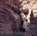
Elves Chasm
1956
uum_map_rr
728
Elves Chasm
1956
uum_map_rr
729
Elves Chasm
1956
uum_map_rr
730
Elves Chasm
1956
uum_map_rr
731
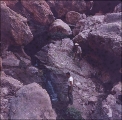
End Cataract
1955
uum_map_rr
732
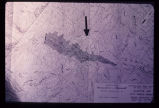
Engineering plan for a proposed reservoir in Salt Lake City. Note the anomalous contour spacing under the arrow. This indicates that the hillside has slid in the past. Construction of a reservoir here would inundate the toe of an ancient landslide and destroy the balance and stability of the weak landslide mass.
Image
uum_map
733
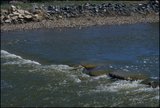
Entering Lodore Canyon through gates of Lodore
1955
uum_map_rr
734
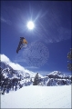
Erik Leines snowboarding at Brighton [1]
1998
uum_map_usa
735
Erik Leines snowboarding at Brighton [2]
1998
uum_map_usa
736
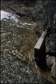
Erosion caused by release of water on severance of aquaduct in foreground. Timpanogas Cave National Monument Visitor Center lies at bottom of canyon.
Image
uum_map
737
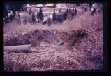
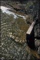
Erosion of a hillside fill- more than 2 feet from a single cloudburst. Sediment is deposited at foot of slope in neighbor's back yard.
Image
uum_map
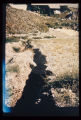
738
Erosion of fill placed from home construction. Deposition of material in foreground gives braided stream appearance.
Image
uum_map
739
European Alps, Iowa Mountaineers 1968 [002]
1968
uum_map_usa
740
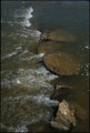
Evanston stream revetments [01]
2002-04-29
uum_map
741
Evanston stream revetments [02]
2002-04-29
uum_map
742
Evanston stream revetments [03]
2002-04-29
uum_map
743
Evanston stream revetments [04]
2002-04-29
uum_map
744
Evanston stream revetments [05]
2002-04-29
uum_map
745
Evanston stream revetments [06]
2002-04-29
uum_map
746
Evanston stream revetments [07]
2002-04-29
uum_map
747
Evanston stream revetments [08]
2002-04-29
uum_map
748
Evanston stream revetments [09]
2002-04-29
uum_map
749
Evanston stream revetments [10]
2002-04-29
uum_map
750
Evanston stream revetments [11]
2002-04-29
uum_map
726
-
750
of
2,440
<
25
26
27
28
29
30
31
32
33
34
>