Home
Browse
Ask Us
Chat
Harmful Language Statement
Log in
University of Utah Marriott Library
Advanced Search
Year
1911
1912
1913
1914
1915
1916
1917
1918
1919
1920
1921
1922
1923
1924
1925
1926
1927
1928
1929
1930
1931
1932
1933
1934
1935
1936
1937
1938
1939
1940
1941
1942
1943
1944
1945
1946
1947
1948
1949
1950
1951
1952
1953
1954
1955
1956
1957
1958
1959
1960
1961
1962
1963
1964
1965
1966
1967
1968
1969
1970
1971
1972
1973
1974
1975
1976
1977
1978
1979
1980
1981
1982
1983
1984
1985
1986
1987
1988
1989
1990
1991
1992
1993
1994
1995
1996
1997
1998
1999
2000
2001
2002
2003
2004
2005
2006
2007
2008
2009
2010
2011
2012
2013
2014
2015
2016
2017
2018
2019
2020
2021
TO
1911
1912
1913
1914
1915
1916
1917
1918
1919
1920
1921
1922
1923
1924
1925
1926
1927
1928
1929
1930
1931
1932
1933
1934
1935
1936
1937
1938
1939
1940
1941
1942
1943
1944
1945
1946
1947
1948
1949
1950
1951
1952
1953
1954
1955
1956
1957
1958
1959
1960
1961
1962
1963
1964
1965
1966
1967
1968
1969
1970
1971
1972
1973
1974
1975
1976
1977
1978
1979
1980
1981
1982
1983
1984
1985
1986
1987
1988
1989
1990
1991
1992
1993
1994
1995
1996
1997
1998
1999
2000
2001
2002
2003
2004
2005
2006
2007
2008
2009
2010
2011
2012
2013
2014
2015
2016
2017
2018
2019
2020
2021
Type
Image
154
Text
3
Image/StillImage
2
Image/MovingImage
1
Format
image/jpeg
154
application/pdf
5
video/mp4
1
Collection
American West Center Research Projects
2
David Oman McKay Papers
1
Photo Archives
156
Utah COVID-19
1
Filters:
Spatial Coverage:
"South America"
26
-
50
of
160
<
1
2
3
4
5
6
7
>
Gallery view
Number of results to display per page
10
25
50
100
200
Sort by Relevance
Sort by Title A-Z
Sort by Title Z-A
Sort by Date Ascending
Sort by Date Descending
Sort by Last Modified Ascending
Sort by Last Modified Descending
Title
Date
Type
Setname
26
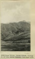
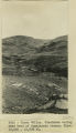
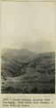
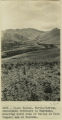
Cuzco Valley. Choquo branch. Looking S or SE across Huancaro from west side.
1912; 1913; 1914; 1915
Image
uum_map
27
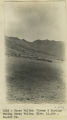
Cuzco Valley. Cirque & Moraine facing Carao Valley. Elev. 13,500-14,000 ft.
1912; 1913; 1914; 1915
Image
uum_map
28
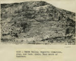
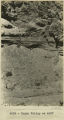
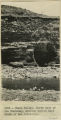
Cuzco Valley. Deposits limestone, clay, and Cast. shale. Near mouth of Huancaro
1912; 1913; 1914; 1915
Image
uum_map
29
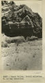
Cuzco Valley. Detail alluvium. N. of San Sebastian [1]
1912; 1913; 1914; 1915
Image
uum_map
30
Cuzco Valley. Detail alluvium. N. of San Sebastian [2]
1912; 1913; 1914; 1915
Image
uum_map
31
Cuzco Valley. Detail.
1912; 1913; 1914; 1915
Image
uum_map
32
Cuzco Valley. Divided spurs. Carao Valley
1912; 1913; 1914; 1915
Image
uum_map
33
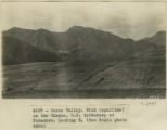
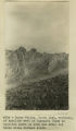
Cuzco Valley. End of abandoned moraine. Largest glacier of Cuzco Valley, Elev. 13,500-13,700 ft. Upper right hand branch of Junajaneha
1912; 1913; 1914; 1915
Image
uum_map
34
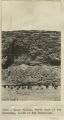
Cuzco Valley. Erosion feature. Pink sandstone. 3 miles north of Angostura
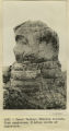
1912; 1913; 1914; 1915
Image
uum_map
35
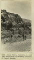
Cuzco Valley. Faulting in Pink Sandstone. Upper Junajaneha
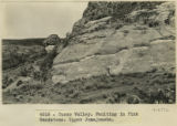
1912; 1913; 1914; 1915
Image
uum_map
36
Cuzco Valley. Fold (syncline) on the Choquo, SE tributary of Huancaro. Looking east [1]
1912; 1913; 1914; 1915
Image
uum_map
37
Cuzco Valley. Fold (syncline) on the Choquo, SE tributary of Huancaro. Looking east [2]
1912; 1913; 1914; 1915
Image
uum_map
38
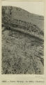
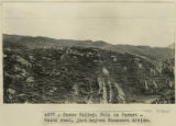
Cuzco Valley. Fold on Paruro-Cuzco road, just beyond Huancaro divide.
1912; 1913; 1914; 1915
Image
uum_map
39
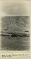
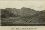
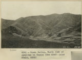
Cuzco Valley. Glaciated valley near head of Junajaneha stream. Elev 13,500-13,800 ft.
1912; 1913; 1914; 1915
Image
uum_map
40
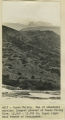
Cuzco Valley. Huancaro, S. bank just below mouth of Huatanay. Material of lowest terrace.
1912; 1913; 1914; 1915
Image
uum_map
41
Cuzco Valley. Junction of Vilcanata and Huatanay, looking down Huatanay. Note high rock cut terrace.
1912; 1913; 1914; 1915
Image
uum_map
42
Cuzco Valley. Looking down Huatanay, from above Anta Branch, 1 mile NW of Cuzco.
1912; 1913; 1914; 1915
Image
uum_map
43
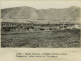
Cuzco Valley. Looking south across Huancaro, below mouth of Huatanay
1912; 1913; 1914; 1915
Image
uum_map
44
Cuzco Valley. Mouth of Huatanay, looking upstream from East side Vilcanata. Note terrace and gorge
1912; 1913; 1914; 1915
Image
uum_map
45
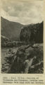
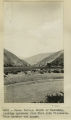
Cuzco Valley. Narrows, looking upstream from 1,000 feet below Angostura.
1912; 1913; 1914; 1915
Image
uum_map
46
Cuzco Valley. North bank of the Hautanay, showing buried wall South of San Sebastian.
1912; 1913; 1914; 1915
Image
uum_map
47
Cuzco Valley. North bank of the Huatanay, south of San Sebastian.
1912; 1913; 1914; 1915
Image
uum_map
48
Cuzco Valley. North limb of syncline on Choquo
1912; 1913; 1914; 1915
Image
uum_map
49
Cuzco Valley. North limb, vertical, of syncline west of Ongapata (same as syncline shown in 2996-2997) but three miles further south
1912; 1913; 1914; 1915
Image
uum_map
50
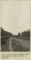
Cuzco Valley. North-flowing, subsequent tributary to Huatanay, entering south side of valley at West (upper) end of Narrows.
1912; 1913; 1914; 1915
Image
uum_map
26
-
50
of
160
<
1
2
3
4
5
6
7
>