Home
Browse
Ask Us
Chat
Harmful Language Statement
Log in
Advanced Search
Year
1846
1847
1848
1849
1850
1851
1852
1853
1854
1855
1856
1857
1858
1859
1860
1861
1862
1863
1864
1865
1866
1867
1868
1869
1870
1871
1872
1873
1874
1875
1876
1877
1878
1879
1880
1881
1882
1883
1884
1885
1886
1887
1888
1889
1890
1891
1892
1893
1894
1895
1896
1897
1898
1899
1900
1901
1902
1903
1904
1905
1906
1907
1908
1909
1910
1911
1912
1913
1914
1915
1916
1917
1918
1919
1920
1921
1922
1923
1924
1925
1926
1927
1928
1929
1930
1931
1932
1933
1934
1935
1936
1937
1938
1939
1940
1941
1942
1943
1944
1945
1946
1947
1948
1949
1950
1951
1952
1953
1954
1955
1956
1957
1958
1959
1960
1961
1962
1963
1964
1965
1966
1967
1968
1969
1970
1971
1972
1973
1974
1975
1976
1977
1978
1979
1980
1981
1982
1983
1984
1985
1986
1987
1988
1989
1990
1991
1992
1993
1994
1995
1996
1997
1998
1999
2000
2001
2002
2003
2004
2005
2006
2007
2008
2009
2010
2011
2012
2013
2014
2015
2016
2017
TO
1846
1847
1848
1849
1850
1851
1852
1853
1854
1855
1856
1857
1858
1859
1860
1861
1862
1863
1864
1865
1866
1867
1868
1869
1870
1871
1872
1873
1874
1875
1876
1877
1878
1879
1880
1881
1882
1883
1884
1885
1886
1887
1888
1889
1890
1891
1892
1893
1894
1895
1896
1897
1898
1899
1900
1901
1902
1903
1904
1905
1906
1907
1908
1909
1910
1911
1912
1913
1914
1915
1916
1917
1918
1919
1920
1921
1922
1923
1924
1925
1926
1927
1928
1929
1930
1931
1932
1933
1934
1935
1936
1937
1938
1939
1940
1941
1942
1943
1944
1945
1946
1947
1948
1949
1950
1951
1952
1953
1954
1955
1956
1957
1958
1959
1960
1961
1962
1963
1964
1965
1966
1967
1968
1969
1970
1971
1972
1973
1974
1975
1976
1977
1978
1979
1980
1981
1982
1983
1984
1985
1986
1987
1988
1989
1990
1991
1992
1993
1994
1995
1996
1997
1998
1999
2000
2001
2002
2003
2004
2005
2006
2007
2008
2009
2010
2011
2012
2013
2014
2015
2016
2017
Type
Image/StillImage
126
Format
application/pdf
126
Collection
Sustainability U
1
UAIDA Main Collection
10
Uintah County Regional History Center...
115
Filters:
Format:
"application/pdf"
Subject:
"Utah"
Type:
"Image/StillImage"
26
-
50
of
126
<
1
2
3
4
5
6
>
Gallery view
Number of results to display per page
10
25
50
100
200
Sort by Relevance
Sort by Title A-Z
Sort by Title Z-A
Sort by Date Ascending
Sort by Date Descending
Sort by Last Modified Ascending
Sort by Last Modified Descending
Title
Date
Type
Setname
26
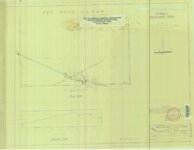
Cowboy #1 Detail of Shaft and Cross Section, 1994
1994
Image/StillImage
ucl_maps
27
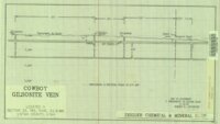
Cowboy - Bandana Gilsonite Vein Plan View and Profile View, 1993
1993
Image/StillImage
ucl_maps
28
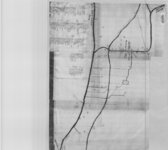
Cowboy Gilsonite Vein Section 33, T8S, R24E, S.L.B.&M. 1994
1994
Image/StillImage
ucl_maps
29
Cowboy Vein Shaft No 1 Horizontal & Vertical Deviation Plat, 1995
1995
Image/StillImage
ucl_maps
30
Cowboy Vein Vertical Hole 71-3 Geologic Section
1975
Image/StillImage
ucl_maps
31
Dragon Area, R25E, Property Map
Image/StillImage
ucl_maps
32
Dry Fork (aka Mountain Dell or Hallsville) prepared by Oral Merkley & Liz Weist
Image/StillImage
ucl_maps
33
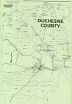
Duchesne County, Utah
Image/StillImage
ucl_maps
34
Duchesne, Duchesne County, Utah, Sanborn Map Company, April 1917
1917
Image/StillImage
ucl_maps
35
Duchesne, Duchesne County, Utah. Sanborn Map Co. April 1917. Corrected July 1931.
1914; 1931
Image/StillImage
ucl_maps
36
East Tavaputs, Utah - Colorado. Reprint edition of Dec. 1885 Map
1885
Image/StillImage
ucl_maps
37
Energy Project Sites, Uintah County 1980s
1980; 1981; 1982; 1983; 1984; 1985; 1986; 1987; 1988; 1989
Image/StillImage
ucl_maps
38
Engineering Cross Section on the Rainbow & Pride-of-the-West Gilsonite Vein
1978
Image/StillImage
ucl_maps
39
Fort Thornburgh, Proposed Reservation for Post
Image/StillImage
ucl_maps
40
General Highway Map - Uintah County, Utah No. 24
Image/StillImage
ucl_maps
41
Geologic Cross Section of the Cowboy Gilsonite Vein (Hand Drawn)
1960
Image/StillImage
ucl_maps
42
Gilsonite Map - Gusher Vein 1988
1988
Image/StillImage
ucl_maps
43
Gilsonite Properties - Bonanza Area 1979
1979
Image/StillImage
ucl_maps
44
Gilsonite Vein System - Geologic Map of the Ute Area
1977
Image/StillImage
ucl_maps
45
Goshute Skull Valley Reservation Geothermal Resources Map
2004-01-14
Image/StillImage
uaida_main
46
Green River - Flaming Gorge National Recreation Area, Ashley National Forest
Image/StillImage
ucl_maps
47
H. Bert and Diana Jensen Home Directions
Image/StillImage
ucl_maps
48
Hardaway Load - Mineral Survey #5688 - 1907
1907
Image/StillImage
ucl_maps
49
Harris Lode - Mineral Survey #5689 - 1907
1907
Image/StillImage
ucl_maps
50
High Uintas Primitive Area, Wasatch and Ashley National Forests, Utah, Salt Lake and Uinta Special Meridians
1980
Image/StillImage
ucl_maps
26
-
50
of
126
<
1
2
3
4
5
6
>