Over 70,000 photos covering a variety of topics from Marriott Library Special Collections
TO
Filters: Date: "1911" Collection: "uum_map"
| Title | Collection Number And Name | Photo Number | ||
|---|---|---|---|---|
| 276 |
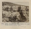 |
Cretaceous Mesa Verde (?) near Crown Point, N.M. 1911 (Photo G304) | P0013 Herbert E. Gregory Photograph Collection | P0013n05_89_0820 |
| 277 |
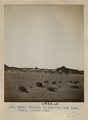 |
Erosion in Dolores near Tuba. Heald, photo. 1911 (Photo G305) | P0013 Herbert E. Gregory Photograph Collection | P0013n05_90_0821 |
| 278 |
 |
Erosion in Dolroes near Tuba. Heald, photo. 1911 (Photo G306) | P0013 Herbert E. Gregory Photograph Collection | P0013n05_91_0822 |
| 279 |
 |
Erosion in Dolroes near Tuba. Heald, photo. 1911 (Photo G306) | P0013 Herbert E. Gregory Photograph Collection | P0013n05_91_0822 |
| 280 |
 |
Herbert E. Gregory Book 13: Photographs taken on Yale Peruvian Expeditions, 1911-1915 | P0013 Herbert E. Gregory Photograph Collection | P0013n13 |
| 281 |
 |
Loading the passengers by means of bucket, coast of Peru | P0013 Herbert E. Gregory Photograph Collection | P0013n13_001_9-2946 |
| 282 |
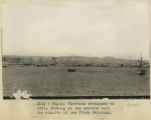 |
Payta, Panprama continues to left, showing at the extreme left the station of the Piura railroad | P0013 Herbert E. Gregory Photograph Collection | P0013n13_001_9-2947 |
| 283 |
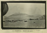 |
Salaverry, harbor and pier | P0013 Herbert E. Gregory Photograph Collection | P0013n13_002_9-2949 |
| 284 |
 |
Pacasmayo. The cliffs and surf with distant view of port and pier from top of cliffs to the northwest | P0013 Herbert E. Gregory Photograph Collection | P0013n13_003_9-2950 |
| 285 |
 |
Payta. The beach. A typical dugout canoe, and characteristic houses of the better class. Looking east | P0013 Herbert E. Gregory Photograph Collection | P0013n13_003_9-2952 |
| 286 |
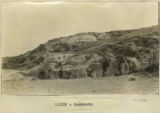 |
Rodadero | P0013 Herbert E. Gregory Photograph Collection | P0013n13_008_9-2961 |
| 287 |
 |
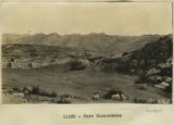
Cuzco Valley | P0013 Herbert E. Gregory Photograph Collection | P0013n13_008_9-2962 |
| 288 |
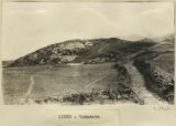 |
Rodadero | P0013 Herbert E. Gregory Photograph Collection | P0013n13_009_9-2963 |
| 289 |
 |
Rodadero | P0013 Herbert E. Gregory Photograph Collection | P0013n13_009_9-2964 |
| 290 |
 |
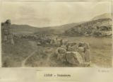
Fort Sacsuahman | P0013 Herbert E. Gregory Photograph Collection | P0013n13_010_9-2965 |
| 291 |
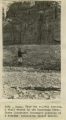 |
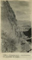
Cuzco. Near the railway station. A bluff washed by the Huantanay River. Shows Lieutenant Sotomayor pointing to a stratum containing fossil shells | P0013 Herbert E. Gregory Photograph Collection | P0013n13_015_9-2975 |
| 292 |
 |
Cuzco. Similar place farther up the Anta road. Dr. Eaton pointing to the spot where a rib was found interstratified with the gravel | P0013 Herbert E. Gregory Photograph Collection | P0013n13_015_9-2976 |
| 293 |
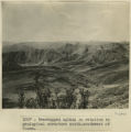 |
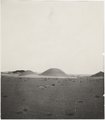
Even topped upland in relation to geological structure south-southwest of Cuzco | P0013 Herbert E. Gregory Photograph Collection | P0013n13_022_9-2990 |
| 294 |
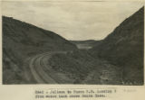 |
Juliaca to Cuzco R.R. Looking S from water tank above Santa Rosa. | P0013 Herbert E. Gregory Photograph Collection | P0013n13_027_9-3000 |
| 295 |
 |
Ollantaytambo. Continuation of panorama to right | P0013 Herbert E. Gregory Photograph Collection | P0013n13_032_9-3009 |
| 296 |
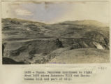 |
Cuzco. Rodadero Hill and Sacsahuaman hill and part of city. | P0013 Herbert E. Gregory Photograph Collection | P0013n13_032_9-3010 |
| 297 |
 |
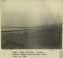
Lake Titicaca. The dark point of land on the left cuts off the view into the Desaguadero River, the outlet of Lake Titicaca. The river rounds the dark point and turns to the left. | P0013 Herbert E. Gregory Photograph Collection | P0013n13_042_9-3029 |
| 298 |
 |
Lake Titicaca. Reed belt, alluvial fringe and tilted strata, border of Lake Titicaca near Guaqui. | P0013 Herbert E. Gregory Photograph Collection | P0013n13_043_9-3031a |
| 299 |
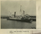 |
Lake Titicaca. Steamer at Guaqui. | P0013 Herbert E. Gregory Photograph Collection | P0013n13_044_9-3031b |
| 300 |
 |
Lake Titicaca. Looking toward Quaqui from the mole built into the lake | P0013 Herbert E. Gregory Photograph Collection | P0013n13_045_9-3033 |