|
|
Title | Collection Number And Name | Photo Number |
| 1 |
 |
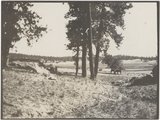
Lower LaPlata, south of Moore's, 1911. | P0013 Herbert E. Gregory Photograph Collection | P0013n04_77_0654 |
| 2 |
 |
Herbert E. Gregory Book 5: Navajo, 1911 | P0013 Herbert E. Gregory Photograph Collection | P0013n05 |
| 3 |
 |
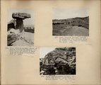
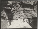
Erosion column. Block of Dakota resting on LaPlata, Southeast of Gallup on west line of Wingate reservation. VII, 3. 1911 (Photo G189) | P0013 Herbert E. Gregory Photograph Collection | P0013n05_01_0662 |
| 4 |
 |
Erosion column. Block of Dakota resting on LaPlata, Southeast of Gallup on west line of Wingate reservation. VII, 3. 1911 (Photo G189) | P0013 Herbert E. Gregory Photograph Collection | P0013n05_01_0662 |
| 5 |
 |
Erosion surface; removal of peneplain; beveled edges of Trias, Southeast of Gallup. VI, 3-10. 1911 (Photo G190) | P0013 Herbert E. Gregory Photograph Collection | P0013n05_01_0663 |
| 6 |
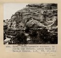 |
Unconformable contact, La Plata and McElmo. South base of Navajo Church, NM. VI, 10. 1911 (Photo G191) | P0013 Herbert E. Gregory Photograph Collection | P0013n05_01_0664 |
| 7 |
 |
Erosion column Southeast Gallup, NM | P0013 Herbert E. Gregory Photograph Collection | P0013n05_01_662_neg |
| 8 |
 |
Concretions in sandstone. North base of Navajo Church. Grover, Navajo, in picture. VI, 11. 1911 (Photo G192) | P0013 Herbert E. Gregory Photograph Collection | P0013n05_02_0665 |
| 9 |
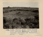 |
Farmer Ants; farm fenced with Russian thistles, on road between Defiance and Manuelito, AZ. 1911 (G193) | P0013 Herbert E. Gregory Photograph Collection | P0013n05_02_0666 |
| 10 |
 |
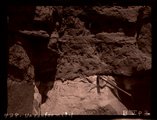
Unconformity. Base of Dakota in section VI, 15. West of Manuelito, NM. 1911 (Photo G194) | P0013 Herbert E. Gregory Photograph Collection | P0013n05_02_0667 |
| 11 |
 |
Unconformity. Base of Dakota in section VI, 15. West of Manuelito, NM. 1911 (Photo G194) | P0013 Herbert E. Gregory Photograph Collection | P0013n05_02_0667 |
| 12 |
 |
Unconformity | P0013 Herbert E. Gregory Photograph Collection | P0013n05_02_667_neg |
| 13 |
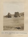 |
Haystacks near St. Michaels. 1911 (Photo G195) | P0013 Herbert E. Gregory Photograph Collection | P0013n05_03_0668 |
| 14 |
 |
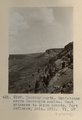
View looking west over Moencopie, dark red shales. West entrance to Canon Bonito, Fort Defiance, AZ. 1911. VI, 57 (Photo G196) | P0013 Herbert E. Gregory Photograph Collection | P0013n05_03_0669 |
| 15 |
 |
Sandstones above Moencopie shales. West entrance to Canon Bonito, Fort Defiance, AZ. 1911. VI, 57 (Photo G197) | P0013 Herbert E. Gregory Photograph Collection | P0013n05_04_0670 |
| 16 |
 |
Unconformity, Shinarump on Moencopie, Ft. Defiance. 1911 (Photo N-M107) | P0013 Herbert E. Gregory Photograph Collection | P0013n05_04_0671 |
| 17 |
 |
Shinarump on Moencopie, North of Ft. Defiance. 1911 (Photo G198) | P0013 Herbert E. Gregory Photograph Collection | P0013n05_05_0672 |
| 18 |
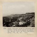 |
General view of LaPlata and McElmo taken from point on Dakota, Northeast of Fort Defiance, AZ. VI, 45, 55. 1911 (Photo G199) | P0013 Herbert E. Gregory Photograph Collection | P0013n05_05_0673 |
| 19 |
 |
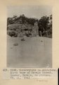
Erosion column on Defiance-Tohatchie road, West of Tohatchie, NM, near top of Cretaceous. Mrs. Gregory, photo. 1911 (Photo G200) | P0013 Herbert E. Gregory Photograph Collection | P0013n05_06_0674 |
| 20 |
 |
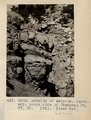
Details of erosion, Mesa Verde, on Ft. Defiance-Tohatchie road, NM. Fossils at base of cap. 1911 (Photo N-M108) | P0013 Herbert E. Gregory Photograph Collection | P0013n05_06_0675 |
| 21 |
 |
Details of erosion near top of Cretaceous, on Ft. Defiance-Tohatchie Road, NM. Fossils occur at base of cap. 1911 (Photo G201) | P0013 Herbert E. Gregory Photograph Collection | P0013n05_07_0676 |
| 22 |
 |
Details of erosion. Tertiary. South side Choiskai Mt. VI, 30. 1911. Plant bed. (Photo G203) | P0013 Herbert E. Gregory Photograph Collection | P0013n05_07_0677 |
| 23 |
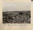 |
General view, Choiskai Mt. Tertiary. From south. 1911 (Photo G202) | P0013 Herbert E. Gregory Photograph Collection | P0013n05_07_0678 |
| 24 |
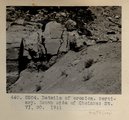 |
Details of erosion. Tertiary. South side of Choiskai Mt. VI, 30. 1911 (Photo G204) | P0013 Herbert E. Gregory Photograph Collection | P0013n05_08_0679 |
| 25 |
 |
Lake, eastern terrace of Choiskai Mt., NM (Photo G205) | P0013 Herbert E. Gregory Photograph Collection | P0013n05_08_0680 |