Home
Browse
Ask Us
Chat
Harmful Language Statement
Log in
Advanced Search
Year
1873
1874
1875
1876
1877
1878
1879
1880
1881
1882
1883
1884
1885
1886
1887
1888
1889
1890
1891
1892
1893
1894
1895
1896
1897
1898
1899
1900
1901
1902
1903
1904
1905
1906
1907
1908
1909
1910
1911
1912
1913
1914
1915
1916
1917
1918
1919
1920
1921
1922
1923
1924
1925
1926
1927
1928
1929
1930
1931
1932
1933
1934
1935
1936
1937
1938
1939
1940
1941
1942
1943
1944
1945
1946
1947
1948
1949
1950
1951
1952
1953
1954
1955
1956
1957
1958
1959
1960
1961
1962
1963
1964
1965
1966
1967
1968
1969
1970
1971
1972
1973
1974
1975
1976
1977
1978
1979
1980
1981
1982
1983
1984
1985
1986
1987
1988
1989
1990
1991
1992
1993
1994
1995
1996
1997
1998
1999
2000
2001
2002
TO
1873
1874
1875
1876
1877
1878
1879
1880
1881
1882
1883
1884
1885
1886
1887
1888
1889
1890
1891
1892
1893
1894
1895
1896
1897
1898
1899
1900
1901
1902
1903
1904
1905
1906
1907
1908
1909
1910
1911
1912
1913
1914
1915
1916
1917
1918
1919
1920
1921
1922
1923
1924
1925
1926
1927
1928
1929
1930
1931
1932
1933
1934
1935
1936
1937
1938
1939
1940
1941
1942
1943
1944
1945
1946
1947
1948
1949
1950
1951
1952
1953
1954
1955
1956
1957
1958
1959
1960
1961
1962
1963
1964
1965
1966
1967
1968
1969
1970
1971
1972
1973
1974
1975
1976
1977
1978
1979
1980
1981
1982
1983
1984
1985
1986
1987
1988
1989
1990
1991
1992
1993
1994
1995
1996
1997
1998
1999
2000
2001
2002
Type
Image
269
Image/StillImage
140
Text
5
Format
image/jpeg
413
Collection
Art and Art History
169
Beckwith Photograph Collection
8
Classified Photographs
62
Clifton Bray Film Negatives
10
Extractions from the Land: Mining and...
2
Olympic Legacy
5
Peoples of Utah Revisited
1
Photo Archives
12
Salt Lake Tribune Negative Collection
14
Shipler Collection Negative Preservat...
18
Shipler Commercial Photographers
6
Ski and Snow Sports Archives
1
UAIDA Main Collection
98
Vernal Express Photographs
2
Westminster College Photographs
5
More
Filters:
Format:
"image/jpeg"
Subject:
"Maps"
401
-
425
of
413
<
8
9
10
11
12
13
14
15
16
17
>
Gallery view
Number of results to display per page
10
25
50
100
200
Sort by Relevance
Sort by Title A-Z
Sort by Title Z-A
Sort by Date Ascending
Sort by Date Descending
Sort by Last Modified Ascending
Sort by Last Modified Descending
Title
Date
Type
Setname
401
Utah Churches, Schools, Missions SE.
Image
wc_pc
402
Utah County--Maps Traffic Accidents
1939-09
Image/StillImage
dha_sltnc
403
Utah Highway Patrol p. 1
1935; 1936; 1937; 1938; 1939; 1940; 1941; 1942; 1943; 1944; 1945; 1946; 1947
Image/StillImage
dha_cp
404
Utah Power & Light Company, Copy of Map Showing Location of Electric Ranges
1925-08-06
Image/StillImage
dha_scnpp
405
Utah Power Blueprint, Ratliff Tunnel
1923-11-27
Image
dha_scp
406
Ute Indians: Before and after White Contact
1966
Text
uaida_main
407
Ute Lands, 1868
Image/StillImage
uaida_main
408
View of Venice
Image
uu_aah_art
409
View of Venice (detail)
Image
uu_aah_art
410
Visits to Mountain Meadows by Frank A. Beckwith [13]
1950
Image
dc_bpc
411
Visits to Mountain Meadows by Frank A. Beckwith [14]
1950
Image
dc_bpc
412
W. F. Bulkley photographs, poster 03, photo 06: Map of Wasatch mountain range
1925; 1926; 1927; 1928; 1929; 1930; 1931; 1932; 1933; 1934; 1935
Image
uum_map
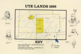
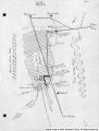
413
World Map showing areas controlled by Europeans, European Settlers, and Non-Europeans in 1922
Image
uu_aah_art
401
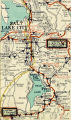
-
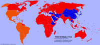
425
of
413
<
8
9
10
11
12
13
14
15
16
17
>