Home
Browse
Ask Us
Chat
Harmful Language Statement
Log in
Photo Archives
Advanced Search
About
Over 70,000 photos covering a variety of topics from Marriott Library Special Collections
Year
1900
1901
1902
1903
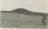
1904
1905
1906
1907
1908
1909
1910
1911
1912
1913
1914
1915
1916
1917
1918
1919
1920
1921
1922
1923
1924
1925
1926
1927
1928
1929
1930
1931
1932
1933
1934
1935
1936
1937
1938
1939
1940
1941
1942
1943
1944
1945
1946
1947
1948
1949
1950
1951
1952
1953
1954
1955
1956
1957
1958
1959
1960
1961
1962
1963
1964
1965
1966
1967
1968
1969
1970
1971
1972
1973
1974
1975
1976
1977
1978
1979
1980
1981
1982
1983
TO
1900
1901
1902
1903
1904
1905
1906
1907
1908
1909
1910
1911
1912
1913
1914
1915
1916
1917
1918
1919
1920
1921
1922
1923
1924
1925
1926
1927
1928
1929
1930
1931
1932
1933
1934
1935
1936
1937
1938
1939
1940
1941
1942
1943
1944
1945
1946
1947
1948
1949
1950
1951
1952
1953
1954
1955
1956
1957
1958
1959
1960
1961
1962
1963
1964
1965
1966
1967
1968
1969
1970
1971
1972
1973
1974
1975
1976
1977
1978
1979
1980
1981
1982
1983
Type
Image
661
Format
application/pdf
661
Collection Name
Olive Woolley Burt
495
Everett Ruess Family
70
Leo Leonard
48
Herbert E. Gregory
32
Wallace Stegner
9
Vern Adix
4
Rocky Mountain Power Company
2
Allen Publishing Company
1
More
Filters:
Date:
"1944"
Format:
"application/pdf"
Collection:
"uum_map"
Type:
"Image"
1
-
25
of
661
<
1
2
3
4
5
6
7
8
9
10
>
Gallery view
Number of results to display per page
10
25
50
100
200
Sort by Relevance
Sort by Title A-Z
Sort by Title Z-A
Sort by Date Ascending
Sort by Date Descending
Sort by Last Modified Ascending
Sort by Last Modified Descending
Sort by Photo Number
Title
Collection Number And Name
Photo Number
1
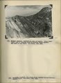
Herbert E. Gregory Book 12: Colorado Plateau, Province, 1942-1944
P0013 Herbert E. Gregory Photograph Collection
P0013n12
2
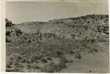
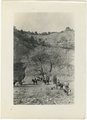
West wall of Seaman Wash
P0013 Herbert E. Gregory Photograph Collection
P0013n12_032_2880
3
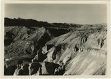
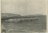
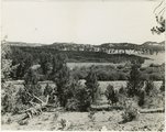
Looking south, up dip, across West Clark Bench, Upper Jurassic and Dakota (butte), to the Paria Terrace, Navajo sandstone. Paria River, which passes through 'The Gap' is joined by Kaibab Creek. Kane County, UT. 1944
P0013 Herbert E. Gregory Photograph Collection
P0013n12_036_2883
4
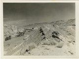
Looking south (up dip) down the Paria River, which has widened its floor and dissected its borders in Upper Jurassic rocks (foreground) and cut a deep narrow canyon in the Navajo sandstone (background). Site of the abandoned Adairville. Kane County UT, 1944
P0013 Herbert E. Gregory Photograph Collection
P0013n12_038_2885
5
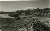
Flat lying Upper Jurassic (foreground) and Cretaceous strata bed abruptly upward against the Navajo on the flank of the East Kaibab monocline (left sky line). Table Cliffs (right sky line) is about 50 miles north. Paria Valley near Adairville. Kane County, UT. 1944
P0013 Herbert E. Gregory Photograph Collection
P0013n12_039_2886
6
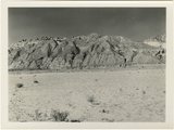
Eroded flank of the East Kaibab monocline at the junction of Paria River and Cottonwood Creek (left center). The sequence is Navajo (left), upper Jurassic (largely eroded), Dakota, Tropic, and Straight Cliffs. Kane County, UT, 1944
P0013 Herbert E. Gregory Photograph Collection
P0013n12_040_2887
7
Looking south along Paria River from the mouth of Shurtz Gorge. Navajo sandstone in East Kaibab monocline is overlaid with decreasing dips by Upper Jurassic (banked against the Navajo), Dakota, and Tropic (foreground and left sky line). Erosion surface (middle distance) bevels upturned rocks. Kane County, UT, 1944
P0013 Herbert E. Gregory Photograph Collection
P0013n12_041_2888
8
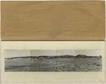
Panorama {c}. Flank of East Kaibab monocline, bordering alluvial floor of Paria Valley. Navajo sandstone (middle sky line), Upper Jurassic strata, and basal Cretaceous (left). Dips of 40 degrees decrease to 3 degrees within 1,000 feet. Kane County, UT, 1944
P0013 Herbert E. Gregory Photograph Collection
P0013n12_042_2891
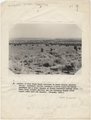
9
Kaibab limestone (lower wall,left, breccia (marks unconformable contact), and basal Moenkopi limestone and shales. Mouth of Kaibab Gulch. Kane County, UT, 1944
P0013 Herbert E. Gregory Photograph Collection
P0013n12_047-048_2899
10
Mesa capped by Dakota sandstone eroded from upper Jurassic Winsor (?) formation. Head of Ash Creek. Kane County, UT
P0013 Herbert E. Gregory Photograph Collection
P0013n12_051_2903A
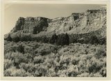
11
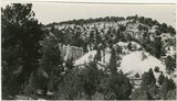
Section of the Shinarump Cliffs (middle distance), east of Pioneer Gap. Shinarump conglomerate exposed by erosion of Moenkopi formation below and the basal strata of the Chinle formation above. Upper Chinle sandstones form Vermilion Cliffs (background).
P0013 Herbert E. Gregory Photograph Collection
P0013n12_052B
12
Panorama--4 photographs. Blue Springs meadows. A former valley leading to Mammoth Creek blocked by basalts from Miller Knoll (right skyline) became a lake that eventually cut an outlet northward through the Brian Head formation (upper left). Garfield County, UT, 1944
P0013 Herbert E. Gregory Photograph Collection
P0013n12_068-069_pan
13
Brian Head formation, branch of Asay Creek; lies beneath basalt flows. Garfield County, UT, 1944
P0013 Herbert E. Gregory Photograph Collection
P0013n12_072_2935
14
Sevier River formation overlaid by basalt near mouth of Corral Creek on Highway 89, 2 miles east of Panguitch. Garfield County, UT. 1944
P0013 Herbert E. Gregory Photograph Collection
P0013n12_075_2940A
15
Bowers Knoll; Volcano viewed from northwest. Garfield County, UT. 1944
P0013 Herbert E. Gregory Photograph Collection
P0013n12_076_2940B
16
Hillside of eroded rock, Paria Valley, Utah
P0013 Herbert E. Gregory Photograph Collection
P0013n16_12_01
17
Road and lava field, Rock Creek Valley, Utah
P0013 Herbert E. Gregory Photograph Collection
P0013n16_12_02
18
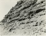
Rocky cliff near Hillsdale
P0013 Herbert E. Gregory Photograph Collection
P0013n16_12_03
19
Lava, Black Rock Valley
P0013 Herbert E. Gregory Photograph Collection
P0013n16_12_04
20
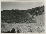
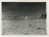
Paria Valley and east flank of East Kaibab monocline
P0013 Herbert E. Gregory Photograph Collection
P0013n16_12_05
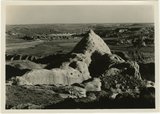
21
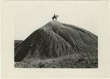
Mound of sedimentary material, vicinity of Paria River, Utah
P0013 Herbert E. Gregory Photograph Collection
P0013n16_12_06
22
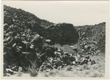
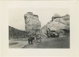
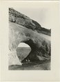
Sandstone outcrops, Paria Canyon, Utah
P0013 Herbert E. Gregory Photograph Collection
P0013n16_12_07
23
Paria Canyon, Utah
P0013 Herbert E. Gregory Photograph Collection
P0013n16_12_08
24
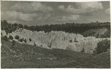
White rocks on road to Panquitch, Utah
P0013 Herbert E. Gregory Photograph Collection
P0013n16_12_09
25
East side of Lone Rock on Wah Weap Creek
P0013 Herbert E. Gregory Photograph Collection
P0013n16_12_10
1
-
25
of
661
<
1
2
3
4
5
6
7
8
9
10
>